← Return to Module 3
ITS ePrimer Presentation
Module 3: Application of ITS in Transportation Systems Management and Operations
Slide 1:

ITS ePrimer
Module 3: Application of ITS in Transportation Systems Management and Operations (TSMO)
ITS Professional Capacity Building Program
ITS Joint Program Office
U.S. Department of Transportation
Author’s Slide 1 meeting notes below:
This is the title Slide. The following Slides are in this order:
- Instructor
- Learning Objectives
- Content-related Slide(s)
- Summary (what we have learned)
- References
- Questions?
This module is sponsored by the U.S. Department of Transportation’s ITS Professional Capacity Building (PCB) Program. The ITS PCB Program is part of the Research and Innovative Technology Administration’s ITS Joint Program Office.
Thank you for participating and we hope you find this module helpful.
Slide 2:
Instructor - Todd Szymkowski, P.E., PTOE, PMP

- 25 Years Experience
- BS and MS in Civil Engineering
- Senior Project Manager at Gannett Fleming
- ITS Systems Engineering & Design
- TSMO Program Planning
- TSMO Workforce Development
- Traffic Incident Management
- Traffic Operations Research
Slide 3:
Learning Objectives
- Understand how ITS enables an organization to achieve its TSMO goals and objectives
- Understand the fundamental ITS building blocks that collectively provide real-time and historical information to help maximize existing transportation network capacity while maximizing safety
- Learn how organizations need to evolve their workforce to meet emerging needs
- Introduce several emerging issues and technologies related to ITS in TSMO
Slide 4:
Module Overview
- Introduction
- Transportation Management Centers
- Freeway Management
- Arterial Management
- Integrated Corridor Management
- Other Applications and Modes
- Emerging Technologies
- Workforce Management and Development
- Summary and Future Considerations
Slide 5:
Introduction
Defining TSMO
“An integrated set of strategies to optimize the performance of existing infrastructure through the implementation of multimodal and intermodal, cross-jurisdictional systems, services, and projects designed to preserve capacity and improve security, safety, and reliability of the transportation system.”
- FHWA, “What is TSMO?” Website
Benefits
- Improved quality of life
- Smoother and more reliable traffic flow
- Improved safety
- Reduced congestion
- Less wasted fuel
- Cleaner air
- Increased economic vitality
- More efficient use of resources (facilities, funding)
Author’s Slide 5 meeting notes below:
Purpose
The purpose of this module is to provide a broad overview of intelligent transportation systems (ITS) technology and tools used to manage transportation strategies, systems, and networks to maximize mobility, reliability, safety, and system efficiency. The technology and tools support a number of transportation systems management and operations (TSMO) applications ranging from the centers that collect and synthesize a wide range of data, mobile and fixed sensors in the field that collect data, and the types of communications that enable connectivity. Emerging issues and technologies anticipated to influence the application of ITS in TSMO are also highlighted.
FHWA defines TSMO as “an integrated set of strategies to optimize the performance of existing infrastructure through the implementation of multimodal and intermodal, cross-jurisdictional systems, services, and projects designed to preserve capacity and improve security, safety, and reliability of the transportation system.” The strategies are broad and have been embraced by agencies because of their high return on investment compared to larger, capital intensive infrastructure projects that require significant time and resources. Benefits of TSMO include:
- Improved quality of life
- Smoother and more reliable traffic flow
- Improved safety
- Reduced congestion
- Less wasted fuel
- Cleaner air
- Increased economic vitality
- More efficient use of resources (facilities, funding)
Slide 6:
Introduction
Fundamental Elements of ITS that enable TSMO
- Centers - Gather information from a variety of sources
- Field Devices - Equipment that provides data and supports command and control decisions
- Communications - Connectivity between the field and center
- Vehicles, Pedestrians, Bicycles, and other forms of Surface Transportation - Primary sources of data
Author’s Slide 6 meeting notes below:
Fundamentally, there are a several components that need to be considered when developing ITS that enables TSMO:
- Centers - gather information from a variety of sources including field devices, other agencies, and vehicles that are typically integrated through hardware and software to make a variety of command-and-control decisions.
- Field Devices - equipment installed primarily within right of way or within the road that feeds data into associated centers to make effective operational decisions.
- Communications - connects centers to field devices and critical to making timely and effective operations decisions. Takes the form of robust, redundant communications and targeted remote wireline or wireless communications typically that ensures defined continuity of operations thresholds. For very critical communications connections, there is often an added level of hardening, such as encasing conduit in concrete or designing access points to be maintained during extreme weather events.
- Vehicles, Pedestrians, Bicycles, and other Forms of Surface Transportation - feed the data to the centers from field devices via communications. As smart phones continue to advance with widespread coverage, more applications are using the devices to support a wide range of transportation applications.
Slide 7:
Transportation Management Centers
Many Types of TMCs
- Functions - Freeway, Arterial, Transit, Maintenance, Tolling, Long-Term Work Zone, Special Events
- Geographic Coverage - Multistate, Statewide, Region, County, Municipality, Project
- Agencies - Single, Multiple, Different Disciplines
- Staff Types - Public, Private, Combination, Law Enforcement Liaisons
Author’s Slide 7 meeting notes below:
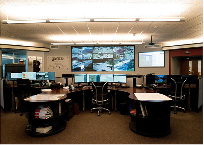
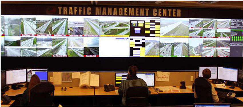
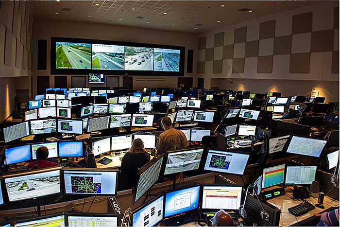
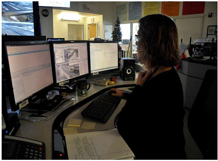
At the heart of any TSMO operation is the transportation management center (TMC). Some agencies use similar names such as traffic operations center, transit dispatch center, or traffic management center. TMCs come in many shapes and sizes, with differing functions, hours of operation, scope, and hierarchy. Some TMCs are operated 24/7/365, depending on the scope of their role in managing transportation, while others may have limited hours focused on peak travel times or during special events. Some TMCs can be single purpose or multi-purpose, combining different functional areas such as freeway, arterial, and transit management. In some cases, there are TMC operations established remotely on a part-time basis to support large special events such as sporting or concert events. Figures 1-3 show examples of several TMCs.
Slide 8:
Transportation Management Centers
Author’s Slide 8 meeting notes below:
Lake County TMC (Libertyville, Illinois), Northern Chicagoland suburban area
Slide 9:
Transportation Management Centers
Author’s Slide 9 meeting notes below:
Iowa DOT TMC (Ankeny, IA)
Slide 10:
Transportation Management Centers
Author’s Slide 10 meeting notes below:
Houston TransStar -partnership of representatives from the City of Houston, Harris County, METRO and TxDOT
Slide 11:
Transportation Management Centers
TMC Command and Control
- Control Room
- Workstations
- Server Room
- High-Visibility Displays
- Dedicated Staffing
- Partner Organization Coordination
Author’s Slide 11 meeting notes below:
Picture is from Wisconsin DOT Statewide TOC (Milwaukee, WI)
TMCs typically are comprised of similar elements including:
TMC COMMAND AND CONTROL
- Control Room - Usually a secured environment that houses operator workstations and high visibility displays.
- Workstations - Depending on the scope of the TMC, there may be anywhere between one and several dozen workstations that allow operators capabilities to control field devices based on data and other sources. Significant effort typically goes into workstation design because of the long hours operators typically work. Many workstations are ergonomically friendly with adjustable heights and individual environmental controls as shown in Figure 4.
- Server Room - One of the costliest parts of the TMC where servers and other IT equipment are located that support the TMC functions. Server rooms are typically equipped with raised floors, special heating, ventilation, and air conditioning (HVAC) systems, and specialized inert-gas fire suppression. To help manage costs and to provide an added level of redundancy, many TMCs are transitioning to cloud-based services applications and data storage.
- High-Visibility Displays - One of the main ways of providing situational awareness beyond workstations is large displays. Displays can range from complex video walls to a series of large monitors positioned at key locations in the TMC.
- Dedicated Staffing - TMCs requires staff with a special set of skills that are becoming increasingly more complicated as enabling systems become more complex. Many TMCs are staffed through private sector contracting.
- Partner Organization Cooperation - Whether virtual or in person, many organizations gain value in working side by side. Examples of partners working closely in person or virtually with transportation (highway) organizations include law enforcement, transit, emergency management, regional planning organizations and tolling. In some cases, partnering helps support the long-term financial stability of the TMC through multiple funding sources. Development of regional or statewide ITS architecture is a valuable tool that helps clarify ITS functions, device ownership, and the roles and responsibilities of partner organizations.
The 2018 FHWA Human Factors Guide provides additional information on issues that need to be addressed during TMC planning and design.
Slide 12:
Transportation Management Centers
TMC
TELECOMMUNICATIONS
- Redundant TMC Telecommunications
- Redundant Field Telecommunications
SUPPORTING TMC FACILITY FEATURES
- Facility Resilience
- Long-Term Event Capabilities
- Areas for Collaboration
- Areas for Media
Author’s Slide 12 meeting notes below:
Typical Features and Characteristics of TMCS:
TMC TELECOMMUNICATIONS
- Redundant TMC Telecommunications - Most TMCs use telephones that rely on an internet connection (i.e., Voice over IP). When power and/or internet goes down, the TMC can be cut-off from communicating with others. Having access to plain old telephone service (POTS) telephones that can operate without power or other modes (e.g., satellite) available is critical to maintain communications when it is likely most needed.
- Redundant Field Telecommunications - Many TMCs are connected to public and private sector fiber networks. To be truly redundant means having two or more different building entrances where cabling does not share the same trench.
SUPPORTING TMC FACILITY FEATURES
- Facility Resilience - Many TMCs have back-up power generators that can be refueled if needed in the event of major emergencies. Other locations have been built to withstand seismic and extreme weather events.
- Facilities for Long-Term Events - Because TMCs routinely become the focal point for transportation agency response during a major emergency, facilities like showers, locker rooms, food storage, and even short-term sleeping quarters are provided at larger TMCs. In many locations, the TMC serves dual purpose as the area emergency operations center and may have emergency management staff located in the same facility.
- Areas for Collaboration - TMCs often have space for collaboration with internal and external partners, typically in the form of conference rooms, usually equipped with video conferencing capabilities.
- Areas for Media - Many TMCs are attractive locations for media outlets to broadcast from. Media can be a valuable partner in sharing traveler information and providing a place for routine broadcasting can lead to long-term, positive partnerships.
Slide 13:
Transportation Management Centers
TYPICAL TMC TOOLS
- Freeway-Oriented Advanced Traffic Management System (ATMS)
- Arterial-oriented ATMS
- Advanced Traveler Information System (ATIS)
- Multi-modal / Integrated Corridor Management (ICM) Decision Support
- Work Zone/Special Event Management
- Emergency Management
- Dispatching
- Network (Telecom) Operations
Author’s Slide 13 meeting notes below:
There are several tools typically used at the TMC that enable TSMO. Examples of the most prevalent tools include:
- Freeway-Oriented Advanced Traffic Management System (ATMS) - ATMS software focused on freeway management is typically centered around supporting recurring congestion through strategies such as ramp metering and non-recurring congestion by supporting response to traffic incidents.
- Arterial-oriented Advanced Traffic Management System - ATMS software focused on arterial management is typically used to optimize traffic signal timing across a corridor or region and enables second-by-second communications.
- Advanced Traveler Information System (ATIS) - ATIS software enables sharing of traveler information through telephone and web. Increasingly, voice-based ATIS systems are being de-emphasized in favor of more location-based services. ATIS is provided by both public sector (e.g., 511 phone and web) and private sector (e.g., WAZE).
- Multi-modal / Integrated Corridor Management (ICM) Decision Support - Decision support software enables informed decision making as corridors get congested or traffic incidents cause major delays. For example, a long-term major crash may suggest a variety of operational strategies based on prevailing and forecasted conditions such as signal timing modifications, supplemental transit service to park and ride lots, reassignment of resource to protect the back of queue, and wide area ramp metering to smooth delays.
- Work Zone/Special Event Management - Work zones and special events often require specialized software that enables access to portable detection and surveillance equipment.
- Emergency Management - Many transportation agencies use tools that allow for improved situational awareness across all the responding agencies. Most times, the transportation organization is one part of a broader large-scale emergency response to natural disasters, major special events, or civil unrest.
- Dispatching - Many TMCs support dispatching safety service patrol vehicles through voice and databased software systems that use automatic vehicle locator/global positioning system (AVL/GPS) to dispatch based on quickest route to the traffic incident.
- Network (Telecommunications) Operations - Some agencies have hundreds of miles of fiber optic cabling connecting to the TMC. Many TMCs operate as a small network operations center (NOC) that monitors the health of operation technology field equipment (e.g., switches, routers, regeneration sites, etc.).
Slide 14:
Transportation Management Centers
CENTER TO FIELD NETWORK CONNECTIVITY
- Direct Wired
- Direct Leased Wired
- Licensed Wireless
- Unlicensed Wireless
- Cellular
CENTER TO CENTER CONNECTIVITY
- Other TMCs
- Transit Management/ Dispatch Centers Emergency Management Centers
- Public Service Answering Points
- Regional Data Archiving
- Public Health Systems
Author’s Slide 14 meeting notes below:
Many organizations have invested heavily over the years to connect centers with a variety of field equipment. The preferred method is direct connections using fiber optic cabling through use of redundant network configurations to minimize the probability of disruptions due to cable cuts, power outages, etc. Other technologies routinely used include leased telecom circuits, licensed and unlicensed wireless, and cellular. Cellular technologies are particularly popular with mobile assets like portable cameras, portable message signs and remote devices like RWIS stations and rural, isolated intersections requiring connectivity.
Many TMCs are connected to other centers to help with data and information sharing. Examples of connections between centers include:
- Other TMCs for sharing wide area and multistate traveler information.
- Transit management/dispatch centers to share video and travel time information from the TMC and bus and rail information from transit, which is especially important within the context of integrated corridor management.
- Emergency management centers to share critical transportation status information during major disasters.
- Public safety answering points (PSAPs) /call centers to facilitate sharing of video from TMC and computer-aided dispatch information for transportation-related events.
- Data sharing by feeding data into a regional archived data repository.
- Public health systems to help expedite delivery of critical medical supplies.
Experiences with pandemics (e.g., COVID in 2020-21) and other health-related issues impacting places where people work close to one another, have amplified the need for remote access to centers. Many TMCs can function in a virtual environment enabling proper social distancing while maintaining a minimum level of core business operations. Other locations that do not have remote access have used back-up TMC locations to help provide proper social distancing. A best practice related to remote access is the need to develop standard operation procedures along with periodic exercises to demonstrate readiness.
Slide 15:
Transportation Management Centers
TYPICAL OPERATIONS EXAMPLES
- Planned Events
- Unplanned Events
- Traffic Signal Control
- Freeway Control
- Operational Technology Maintenance Coordination
- Communications with Partners
- Other Operations
TMC-ENABLED ANALYSIS & PERFORMANCE REPORTING
- Logs, Database Management, System Admin.
- Data, Voice, and Video Archiving
- Device Maintenance/Asset Management
- Safety Analysis
- Traffic Operations Studies
- Investment Evaluation
Author’s Slide 15 meeting notes below:
Operations
Activities in a TMC vary greatly depending on its scope and coverage. Examples of typical operations activities include:
- Planned Events - Events that have pre-established response plans, including special events (e.g., concerts, sporting events, parades, fairs, conventions, races, etc.) and work zones. For example, a special event may include reversible lane operations to accommodate peak traffic demand as motorists enter and leave the site. Most work zones on projects with federal funds require a transportation management plan (TMP), which looks at a variety of operations issues depending on the complexity of the project and associated demand and capacity. Some work zones may employ several TSMO strategies such as designated alternate routes or supplemental ITS equipment to provide queue warnings or maximize available roadway capacity through use of late merge systems.
- Unplanned Events - Responding to traffic incidents, including crashes and stalled vehicles, consumes a significant amount of operator time. TMC operator work related to responding to traffic incidents includes providing real-time traveler information through 511, managing traffic through adjusting ramp meters, adjusting signal timing plans on alternate routes, dispatching safety service patrols, monitoring work zones, and coordinating responses with partner agencies. TMC operators play a key role in responding to a variety of weather phenomena, such as snow, ice, dust, smoke, wind, or flooding. TMCs play a key role in making motorists aware of pending conditions and responding to incidents that occur because of weather. For emergency transportation operations, TMCs provide a critical role in helping to facilitate movement of freight and people during a variety of emergency events. For example, during a major hurricane, TMCs support evacuations through establishment of contraflow operations, while maintaining access for critical emergency responders heading towards the impacted area. During major widespread flooding, TMCs have served in the role of providing traveler information hundreds of miles away in other states warning about long-term Interstate closures.
- Traffic Signal Control - TMCs often serve as the focal point for signal system timing and coordination operations since many of the field controllers are connected remotely through network communications. Traffic signal system maintenance programs are routinely led out of the TMC and are critical to maintaining good traffic flow. Other operations connected to traffic signal systems include transit signal priority and emergency vehicle preemption. Transit signal priority allows buses to send messages to the traffic signal controller indicating it is behind schedule and make small adjustments along a corridor to help with schedule adherence. Emergency vehicle preemption allows for specially equipped first responders to obtain a priority phase to expedite travel time to an incident.
- Freeway Control - TMCs play a key role in freeway control by actively managing a variety of ITS-based tools such as ramp metering, part-time shoulder use, dynamic lane merge, reversible lanes, variable speed limits, and speed harmonization.
- Operational Technology Maintenance Coordination - TMCs rely on access to the tools in the field to manage traffic, provide traveler information, and provide situational awareness to its partners. When a device does not function properly, TMC staff generate trouble tickets, request maintenance, and track progress until the device or communications connection is fixed and operational again.
- Other Operations - TMCs are often extended to take on a variety of operations because of their significant connections to the organization’s operational technology. Examples include bridge, tunnel, railroad, transit, tolling, gates, facility security, irrigation, international border crossings, and interstate port of entry operations.
- Communications with Partners - TMCs typically serve as a clearinghouse of information sharing with partner agencies because of the extended hours of most TMCs.
There are many reporting capabilities of most TMCs that help to accelerate an organization’s TSMO maturity, including:
- Logs, Database Management, System Administration - Records associated with how an agency responded to different events and incidents is critical to creating opportunities for continuous improvement.
- Data, Voice, and Video Archiving - Most organizations collect the data generated by ATMS and other systems that enable TSMO. There is a mix of organizations that archive voice and video due to privacy sensitivities. Regardless of what data is archived, it provides a powerful basis for supporting activities such as traffic incident after-action reviews, engineering studies, personnel oversight, and performance management. Personnel oversight becomes more critical in situations where TMC staff are provided by outside contractors serving as an agent of a public agency.
- Device Maintenance - Many agencies amass hundreds and even thousands of ITS field devices over time. Keeping devices functional is important to provide critical traveler information. TMCs use tools to monitor the health and inventory of devices, sometimes with an integrated ticketing system that triggers further investigation. Maintenance tracking tools also provide foundational information to overall agency transportation asset management activities.
- ATDM/ICM Decisions - Data from arterial and freeway ATMS serves as a basis to provide decision support for ATDM and ICM applications.
- Safety Analysis - Freeway and arterial ATMS are valuable in supporting a variety of safety analyses. Understanding contributing factors related to crashes on a roadway segment can be developed through information that may not be provided on a typical crash report. For example, most TMCs capture disabled vehicle information, which likely does not generate a crash report but could be a contributing factor. Another example is understanding the long-term reliability of a roadway segment. A high standard deviation of travel times may contribute to safety issues.
- Traffic Operations Studies - TMCs can provide a tremendous amount of data to support general traffic studies. Examples include weaving studies, delay/level of service studies, travel time studies, and simulation model calibration.
- Investment Evaluation - TMC data can support agency investment decisions through use of its data. For example, when compared to more traditional highway improvements, TSMO strategies such as safety service patrols or part-time shoulder use provide very competitive benefit-cost ratios.
Slide 16:
Freeway Management
URBAN & SUBURBAN AREA FOCUS
- Congestion management
- Quick clearance
RURAL AREA FOCUS
- Freight flow management
- Weather management
- Traffic incident management
Author’s Slide 16 meeting notes below:
Freeway management techniques using ITS enables agencies to advance TSMO. Freeway management comes in many forms, where urban and suburban areas tend to be more focused on congestion management and quick clearance and rural areas deal with issues to maintain freight flow and support traffic incident management. Responding to incidents in rural areas is typically more challenging because of the timeliness of responses and the reliance on volunteer fire and emergency medical services (EMS) departments.
Slide 17:
Freeway Management
ACTIVE TRAFFIC MANAGEMENT
- Dynamic Lane Use
- Part-Time Shoulder Use
- Variable Speed Limits
- Queue Warning
- Adaptive Ramp Metering
- Speed Harmonization
- Dynamic Lane Merge
Author’s Slide 17 meeting notes below:
ATM consists of a variety of strategies such as dynamic lane use control, part-time shoulder use, variable speed limits, queue warning, adaptive ramp metering, and speed harmonization.
- Dynamic Lane Use - This includes a series of dynamic signs over each lane mounted on sign structures or gantries periodically along a highway to indicate whether a lane is open, closed or slowing ahead.
- Part-Time Shoulder Use - Instead of constructing a costly additional lane, the inside or outside shoulder is used for a portion of the peak travel period where additional capacity is required.
- Variable Speed Limits - Speed limits are changed as advisory or regulatory based on different inputs. For example, some speed limits are adjusted based on prevailing weather conditions and others are based on real-time travel demand.
- Queue Warning - A series of detectors alerts drivers of queues through upstream variable message signs.
- Adaptive Ramp Metering - Ramp metering can break up platoons of vehicles entering the freeway from an on-ramp or another freeway. It provides for safer merging and can spread the delay across multiple ramp entrance locations. Some ramp meters include lane configurations that give high occupancy vehicles their own lane, speeding up entrance to the freeway.
- Speed Harmonization - This uses a series of dynamic message signs or lane control signs to slow traffic in advance of a lane closed by an incident or maintenance work. It also helps to gradually move traffic over and around a closure. Several European countries (e.g., Germany, Netherlands, United Kingdom) have effectively used speed harmonization for many decades.
- Dynamic Lane Merge - This is used at a system interchange when, during a peak period, the lesser facility may carry a higher volume of traffic and require additional capacity. It encourages use of as much roadway capacity as possible by gradually dropping speeds and encouraging motorists to merge at designated locations with dynamic message signs connected to a series of speed and density detectors.
Slide 18:
Freeway Management
ACTIVE TRAFFIC MANAGEMENT
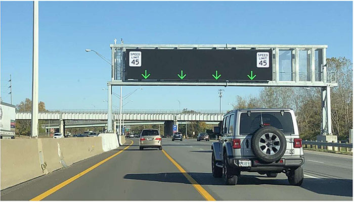
Author’s Slide 18 meeting notes below:
I-680 SmartLane in Columbus, Ohio
Many existing systems include a combination of strategies. For example, Figure 5 shows an installation that includes a combination of part-time shoulder use, variable speed limits, and dynamic lane use.
Slide 19:
Freeway Management
TRAVELER INFORMATION
- Dynamic Message Signs
- Highway Advisory Radio
- 511 Phone
- 511 Web
- Kiosks
- Private Sector TI Providers Data Sharing
Author’s Slide 19 meeting notes below:
Real-time travel information is one of the most important activities a transportation agency can provide to its users. With significant amounts of data coming into a TMC, including feeds from private sector sources, agencies provide real-time traveler information in many forms:
- Dynamic Message Signs - These signs provide incident information, travel times, construction information, weather warnings, and special event travel instructions.
- Highway Advisory Radio - Their use is increasingly being phased out because of newer technology, but they can be used to broadcast long-term incident information, construction information, weather warnings, and special event instructions.
- 511 Phone - 511 is voice recognition-based traveler information that can provide floodgate messages on a variety of wide area alerts (e.g., Amber, Silver, etc.), information on incidents, lane closures, and travel times. Other information may include different modes such as transit.
- 511 Web - Most activity is invested in maintaining an online resource for traveler information. Information can include incidents, lane closures, CCTV images (snapshots or streaming), construction, winter road conditions, truck parking availability, plow locations, and future closures for planning purposes. Many state agencies also have smartphone applications, with fewer at the county and city level.
- Kiosks - Kiosks located at locations like airports, transit hubs, special events, or other major trip generators offer a way for those without smartphones to view nearby travel conditions.
- Private Sector Traveler Information Providers Data Sharing - Many transportation agencies publish information in a standardized format so private sector traveler information providers can integrate into their websites and applications. More formalized agreements allow for two-way data sharing between public and private sectors including probe speed data, crash data, and crowd-source generated information.
FHWA maintains a list of 511 information (https://ops.fhwa.dot.gov/511/). Figure 6 shows a screenshot from a state 511 website.
Slide 20:
Freeway Management
TRAVELER INFORMATION
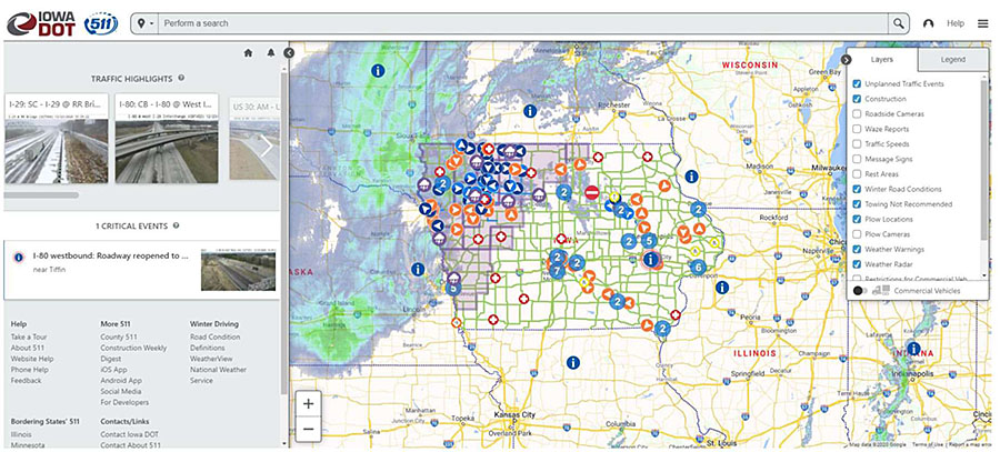
Author’s Slide 20 meeting notes below:
This is an image of the Iowa DOT 511 website. It shows a variety of information such as current weather radar, storm warning areas, CCTV images, Plow cams, Incidents, road closures. The benefit of a site like this is you can tun on different layers to get at the specific type of information you want to look at
Slide 21:
Freeway Management
TRAFFIC INCIDENT MANAGEMENT
- Identify and verify incidents quickly
- Alert approaching motorists
- Coordination w/ Emergency Response Partners
- Dispatch Agency Resources
- Pre-Defined Detour/Alternate Routes
Author’s Slide 21 meeting notes below:
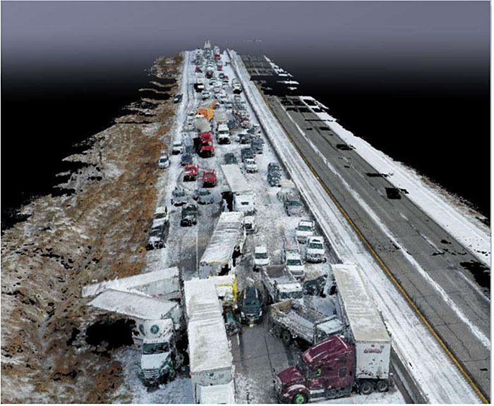
Traffic Incident Management (TIM) within the context of freeway management includes activities to identify and verify incidents quickly through various detection and monitoring techniques. TMCs dispatch safety service patrols and inform motorists of developing queues. During major, long-term incidents, detours may be recommended, and transportation agency resources deployed to assist. Throughout the entire incident cycle, data is being collected related to incident clearance times, roadway clearance times, and secondary crashes.
Slide 22:
Freeway Management
TRAFFIC INCIDENT MANAGEMENT
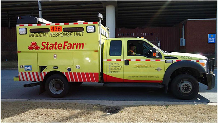
Author’s Slide 22 meeting notes below:
Example HERO Vehicle from Georgia DOT
Safety service patrols are an integral part of most TSMO programs. These programs include a variety of truck types that help stranded motorists, quickly relocate disabled vehicles in hazardous locations, provide traffic control during lane blocking incidents, and help to protect the queue as back-ups develop. Safety service patrol vehicles are becoming advanced technology platforms with:
- AVL/GPS.
- Fixed forward and backward-looking cameras.
- Telescoping cameras with TMC pan-tilt zoom capabilities.
- Laptop computers.
- Weather sensors.
- Flip up dynamic message signs.
Slide 23:
Freeway Management
TRAFFIC INCIDENT MANAGEMENT
Author’s Slide 23 meeting notes below:
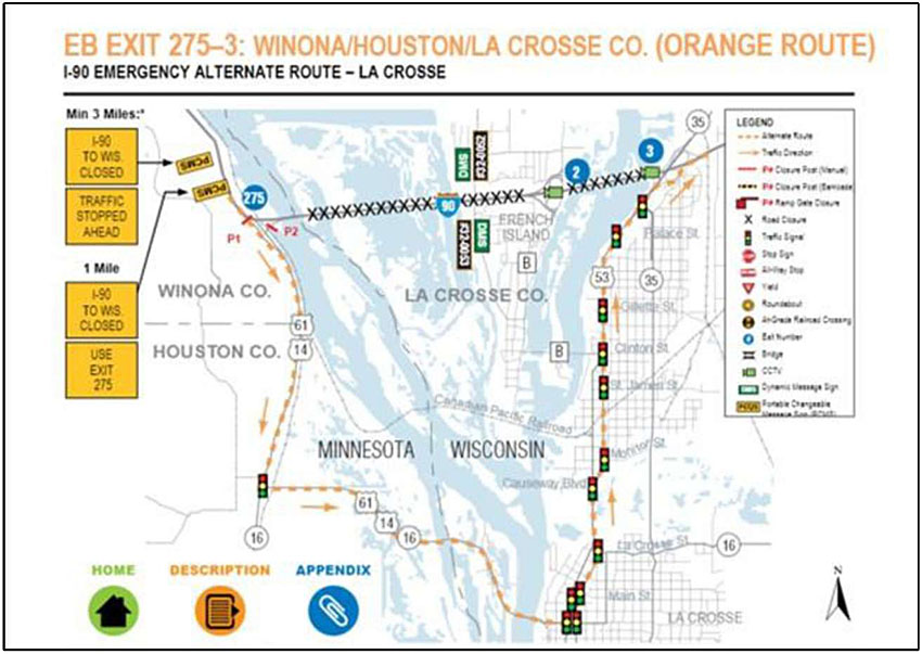
This is an example alternate route plan from Wisconsin DOT for the La Crosse Area (West Central part of state)
Many agencies have developed pre-defined plans for detours or alternate routes for long-term traffic incidents. The plans define what jurisdictions needs to be contacted, what devices and signal timing plans need to be activated, and in some cases, define secondary alternates in case the main detour route has a traffic incident or becomes too congested. Plans also recognize routinely used routes may be congested during a major detour event and help define how emergency response assets can maintain mobility around the community. Figures 8 shows an example alternate/detour plan sheet.
Slide 24:
Freeway Management
WORK ZONE MANAGEMENT
- Supplemental Work Zone Monitoring
- Work Zone Travel Time Systems
- Dynamic Lane Merge Systems
- Trucks Entering/Exiting Systems
- Work Zone Intrusion Systems
- Smart Arrow Boards
Author’s Slide 24 meeting notes below:
A variety of ITS techniques are used to support how work zones are staged and designed to safely accommodate TIM, enforcement activities and how construction equipment enters and exists the roadway. Other techniques include:
- Supplemental Work Zone Monitoring - This uses mobile detectors and cameras connected to the TMC and/or nearby construction management office.
- Work Zone Travel Time Systems - These systems estimate travel times of work zone and alternatives routes using detectors and portable dynamic message signs.
- Dynamic Lane Merge Systems - These encourage the use of as much roadway capacity as possible by gradually dropping speeds and encouraging motorists to merge at designated locations with portable dynamic message signs connected to a series of speed and density detectors.
- Trucks Entering/Exiting Systems - These systems make oncoming motorists aware of slow-moving construction vehicles entering or exiting the highway by activating a changeable message sign or flashing lights on a static sign.
- Work Zone Intrusion Systems - Intrusion systems are geared toward alerting highway workers when a specified perimeter is broken by a vehicle creating a safety hazard.
- Smart Arrow Boards - Arrow boards with an added layer of technology are increasingly being used to provide exact GPS information, time of operation use, and connections to agency TMCs and crowdsourced applications.
Slide 25:
Freeway Management
MANAGED LANES
- Value-Priced Lanes
- Toll Lanes
- High-Occupancy Vehicle (HOV) Lanes
- Truck Lane Restrictions
- Express Lanes
- Reversable Lanes
- High-Occupancy Toll (HOT) Lanes
- Busways
- Transit Lanes
- Truck Lanes
Author’s Slide 25 meeting notes below:
Managed lanes include a variety of facilities that have individual or combined elements of pricing, vehicle eligibility, and access control:
- Value Priced Lanes - Variable price rates apply to using the roadway.
- Toll Lanes - Fixed price rates apply to using the roadway.
- High Occupancy Vehicle (HOV) Lanes - These are access restricted to high-occupancy vehicles.
- Truck Lane Restrictions - Restrictions that limit the lanes trucks can use for safety and asset durability reasons.
- Express Lanes - These are lanes for through traffic with fewer exits.
- Reversable Lanes - These are lanes where traffic direction can be altered in response to conditions.
- High Occupancy Toll (HOT) Lanes - High occupancy vehicles can use these lanes to travel free or at discounted rates depending on demand; other vehicles pay a fee.
- Busways - Busways are facilities dedicated to public transit buses, and light rail transit.
- Transit Lanes - Transit lanes are facilities that accommodate all kinds of transit including buses and taxis.
- Truck Lanes - These are lanes dedicated lanes for semi-trailer trucks.
Slide 26:
Freeway Management
SAFETY SYSTEMS
- Wrong-Way Driving Systems
- Curve Warning Systems
- Over-height Warning Systems
- Virtual Weigh-in Motion Systems
WEATHER WARNING SYSTEMS
- Fog
- Dust
- High water
- High wind
- Visibility
- Ice/surface friction
- Smoke
Author’s Slide 26 meeting notes below:
Many agencies have found benefit in addressing safety hot spots through use of ITS. Examples include:
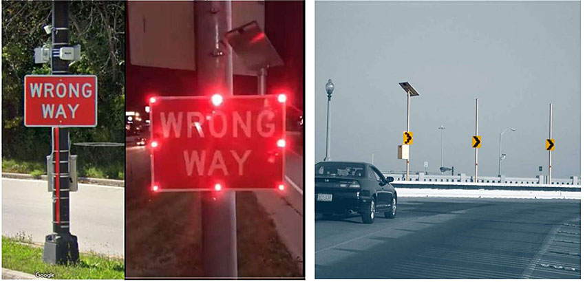
- Wrong-Way Driving Systems - These systems alert law enforcement and TMCs of drivers that travel down a freeway off ramp in the wrong direction. Figure 9 shows an example of a wrong-way driving system.
- Curve Warning Systems - Curve warning systems slow down vehicles on ramps that may experience excessive skidding or overturning. Figure 10 shows an example of a dynamic chevron application on a major system interchange connector ramp.
- Over-height Warning Systems - These systems are used to minimize costly bridge and structure hits.
- Virtual Weigh-in Motion Systems - These can maximize the life of a bridge structures and pavements by monitoring commercial vehicle weights remotely and allowing law enforcement to issue citations to violators a safe downstream location.
Slide 27:
Freeway Management
Author’s Slide 27 meeting notes below:
Both examples are from southeast Wisconsin
The image on the left is an example of wrong way driving system that senses vehicles traveling down a freeway ramp the wrong way then flashes the sign and sends a video clip to the TMC, law enforcement or others.
The image on the right are dynamic chevrons used on a system interchange ramp to warn motorists of the curve. A picture doesn’t fully show how the chevrons operate. The lighting sequencing is similar to airport approach lighting.
Slide 28:
Arterial Management
- Systematic approach that focuses on improved traffic signal and related infrastructure:
- Design
- Operations
- Maintenance practices
- Leads to increased safety, mobility and efficiency for all users
Author’s Slide 28 meeting notes below:
Arterial management includes a systematic approach that focuses on improved design, operations and maintenance practices for traffic signal and other related infrastructure (e.g., mid-block path crossing beacons, schools zone signing, etc.) leading to increased safety, mobility and efficiency for all users. Arterial management techniques using ITS enable agencies to perform and advance TSMO. Like freeway management, arterial management comes in many forms, where dense urban areas tend to be more grid oriented, suburban areas tend to be along commercial corridors, and rural arterial management may include managing the safety surrounding the intersections on State highways.
Slide 29:
Arterial Management
Hierarchy of Traffic Signal Control Strategies
| Category of System Operation |
Level of Detection |
| Uncoordinated Signals |
None |
| Time Base Coordination |
None |
| Interconnected Control |
None |
| Traffic Adjusted Control |
Moderate |
| Traffic Responsive Control |
High |
| Traffic Adaptive Control |
High |
Author’s Slide 29 meeting notes below:
There are a variety of traffic signal systems, each ideally matching the specific travel characteristics of the facility.
Hierarchy of Traffic Signal Systems - Table 2 highlights the hierarchy of traffic signal systems in level of complexity and required detection. A high level of detection means having high fidelity data at lane or movement granularity, and possibly additional midblock detection. Moderate level of detection can be based on overall movement volumes and density.
Slide 30:
Arterial Management
Many Types of Traffic Detection
| Intrusive |
Non-intrusive |
- Induction loops
- Magnetometer
|
- Infrared - Passive and Active
- Video Image Processing
- Thermal Imaging
- Microwave - Doppler and Radar
- Passive Acoustic Array
- Pulsed and Active Ultrasonic
|
Author’s Slide 30 meeting notes below:
Traffic engineers have access to a wide variety of detection, depending on its intended use. In general, there are two groups of detectors: intrusive (i.e., in pavement) and non-intrusive (i.e., mounted above ground).
Each type has their own distinct advantages and disadvantages. For example, the intrusive detectors are typically embedded in the pavement, so when the pavement is torn up, you lose detection, but has been widely used and effective when not disturbed. Whereas video can be moved around and adjusted but may have occlusion issues on roads with high percentages of trucks.
Slide 31:
Arterial Management
Preemption and Priority
- Priority control - signal timing extended or slowed to allow vehicle to pass-through intersection
- Predominantly Bus/LRT to improve schedule adherence
- Applications expanding
- Oversize/overweight freight
- Plowing
- Preemption - all lanes stopped to allow emergency vehicle to pass-through intersection
Author’s Slide 31 meeting notes below:
Transit Signal Priority and Emergency Vehicle Preemption - Traffic signal systems have supplemental equipment to allow buses to improve schedule adherence through priority control and emergency vehicles preempt the signal to enable safe and efficient travel to incidents. Priority control is where signal timing is extended or slowed to allow a vehicle to pass-through the intersection. Preemption is when all lanes are stopped to allow an emergency vehicle to pass-through the intersection. Typically, transmitters are installed on specific vehicles and receivers are installed at the intersections. However, in the case of emergency vehicle preemption, one type of technology uses acoustic signatures from fire apparatus and EMS vehicles for activation. Increasingly, instead of transmitters being installed on vehicles, connected vehicle on-board equipment (OBE) is being used in combinations with roadside units (RSUs) instead of a specialized receiver to facilitate vehicle to infrastructure (V2I) data communications.
Slide 32:
Arterial Management
Automated Traffic Signal Performance Measures
- Approach delay
- Approach volume
- Arrivals on red
- Coordination diagram
- Purdue split failure
- Pedestrian delay
- Phase termination
- Preemption details
- Split failure
- Split monitor
- Turning movement counts
Author’s Slide 32 meeting notes below:
Automated Traffic Signal Performance Measures - In the area of continuous improvement related to arterial management, there has been growing popularity of ATSPM. ATSPM is defined by FHWA as a suite of performance measures, data collection and data analysis tools to support performance-based approaches to traffic signal operations. The measures offered through ATSPM include:
- Approach delay.
- Approach volume.
- Arrivals on red.
- Coordination diagram.
- Purdue split failure.
- Pedestrian delay.
- Phase termination.
- Preemption details.
- Split failure.
- Split monitor.
- Turning movement counts
Slide 33:
Arterial Management
Connected Vehicle Traffic Signal Applications
- Red light violation warning
- Pedestrian in signalized crosswalk warning
- Intelligent traffic signal system
- Signal priority for freight
- Mobile accessible pedestrian signal system
Author’s Slide 33 meeting notes below:
Connected Vehicle Traffic Signal Applications - There are several connected vehicle applications associated with traffic signal systems beyond transit signal priority and emergency vehicle preemption including:
- Red light violation warning.
- Pedestrian in signalized crosswalk warning.
- Intelligent traffic signal system.
- Signal priority for freight.
- Mobile accessible pedestrian signal system.
FHWA Connected Vehicle applications:
https://its.dot.gov/pilots/cv_pilot_apps.htm
Slide 34:
Arterial Management
Information and Guidance Systems
- Parking Information Systems
- Dynamic Trailblazer Signing Systems
- Special Event Reversible Lane Systems
Safety Management Systems
- Intersection Collision Avoidance Systems
- Pedestrian Safety
- Speed Awareness Systems
Author’s Slide 34 meeting notes below:
Information and Guidance Systems
Arterial-oriented information systems help motorists navigate to and from major trip generators. Examples include:
- Parking Information Systems - These provide on-street dynamic signing that broadcasts real-time parking availability information across multiple locations.
- Dynamic Trailblazer Signing Systems - These systems provide information to help direct traffic to the adjacent freeway at the correct locations to help avoid traffic incident queues.
- Special Event Reversible Lane Systems - These are used to maximize roadway capacity when special events (e.g., sporting events) are loading and exiting. Typically, they use a series of two-side lane control signs.
Safety Management Systems
There are several types of arterial-oriented safety systems that use a variety of ITS technologies:
- Intersection Collision Avoidance Systems - These systems assist drivers approaching an intersection understand the state of activities within that intersection through dynamic messaging.
- Pedestrian Safety - Pedestrian safety systems include a variety of strategies such as rectangular rapid flashing beacons and advanced pedestrian detection.
- Speed Awareness Systems - These reinforce existing speed limits with driver feedback signs in areas such as school zones and other high-volume pedestrian areas.
Slide 35:
Arterial Management Arterial Traffic Incident Management
- Similar to freeway application
- Less popular but interest growing
Signal System Maintenance/Asset Management
- Field equipment life-cycle history
- Dispatch scheduling and on-call notification planning
- Trouble ticketing
- Real-time equipment tracking and reporting
- Access to documentation
Author’s Slide 35 meeting notes below:
Arterial Traffic Incident Management
Increasingly, the successes of freeway-oriented TIM programs are being expanded to congested arterials with the same goals of safety of the traveling public and responders, incident scene security, timely traveler information, and improved clearance times. Arterial TIM programs leverage ITS equipment on surface streets to detect and verify events, and specially designated safety service patrol vehicles to respond and provide motorist assistance, traffic control and queue awareness.
Signal System Maintenance/Asset Management
A critical component to the effectiveness of traffic signal systems is the active management of field assets and preventative maintenance, to properly sustain signal operations. Typical elements of a signal system maintenance program include:
- Asset management including field equipment lifecycle history.
- Dispatch scheduling and on-call notification planning.
- Create, dispatch, schedule, prioritize and track trouble tickets and work orders.
- Real-time, location-based equipment tracking and reporting.
- Location-based storage and retrieval of drawings manuals and other documents.
Arterial management ITS infrastructure is one of the components of a TAMP that helps to magnify how operations benefits the organization in meeting its mission. For example, Connecticut DOT (CTDOT) identified several investment strategies in its TAMP related to arterial management including:
- Continue efforts to develop and implement a Traffic Signal Management Plan.
- Continue planning traffic signal replacement projects based on projected age.
- Continue efforts to develop traffic signal component-based life-cycle planning.
Seek to improve traffic operations through enhanced signal control systems.
Slide 36:
Integrated Corridor Management
Approach to improve transportation along a corridor that considers all elements, including highways, arterial roads, and transit systems.
GOALS
- Improving travel time
- Increasing corridor throughput
- Improving travel time reliability
- Improving incident management
- Enabling intermodal travel decision
- Improving safety for all travelers
Author’s Slide 36 meeting notes below:
Integrated Corridor Management (ICM) is an approach to improve transportation along a corridor that considers all elements, including highways, arterial roads, and transit systems. ICM takes a multimodal/multiagency approach to congestion management. ICM uses technology and operational strategies as tools for transportation operators to address recurring and nonrecurring congestion and optimizes performance of the transportation infrastructure. Table 4 shows generalized goals and objectives related to ICM:
Slide 37:
Integrated Corridor Management
CASE STUDIES
Dallas ICM Project
- Decision-Support System
- Actionable Traveler Information
- Interactive Voice Response (IVR) 511
- Website
- Email alerts
- Comparable travel times
- Rerouting of Traffic
- Coordinated timing and adaptive signal control
- Mode Shift
- Parking management
- Real-time service adjustments based on automated passenger counters
KEY FINDINGS
- ICM programs should build on existing institutional arrangements to build consensus
- ICM programs are successful when they benefit all agencies involved
- The easiest way for an ICM program to begin is through data sharing
- ICM must be in regional ITS plans so agencies are committed
- ICM improves collaboration among network partners
- A scaled down version of an ICM decision support system (DSS), when used by capable operators, can effectively manage the corridor
Author’s Slide 37 meeting notes below:
In 2007, the United States Department of Transportation (USDOT) selected eight pioneer demonstration sites across the country to be a part of the Department’s first-ever ICM Initiative. The initial eight sites were narrowed down over time to two locations: Dallas and San Diego, with several objectives:
- Manage the corridor as a system rather than individual assets.
- Enable travelers to make informed travel decisions and dynamically shift modes during a trip.
- Reduce travel delays, fuel consumption, emissions, and incidents.
- Improve travel time reliability and predictability.
- Optimize existing transportation infrastructure along a corridor, making transportation investments go farther.
- Integrated Corridor Management (ICM) Program: Major Achievements, Key Findings, and Outlook: https://ops.fhwa.dot.gov/publications/fhwahop19016/form.htm
Slide 38:
Integrated Corridor Management
CASE STUDIES
San Diego ICM Project
- Automated DSS
- Actionable traveler information
- 511 (phone and website)
- Comparable travel times
- Managed lanes
- Rerouting of traffic
- Coordinated timing and responsive signal operations
- Coordinated ramp metering and traffic signals
- Wayfinding roadway signs for diversion routes
- Mode shift
- Bus rapid transit
- Transit signal priority
- Real-time transit information
KEY FINDINGS
- ICM is a fundamental change in the traffic management paradigm that has offered a more detailed understanding of the corridor and its operations
- Interagency cooperation and coordination were a big success
- Operators reported better situational awareness of corridor conditions, although there were opportunities to improve
- DSS is valuable for better situational awareness, decision-making, and response
- Incident and congestion specific traveler information improved
Slide 39:
Integrated Corridor Management
Attributes of a Successful Site
- Institutional support
- Willingness to change
- Public engagement
- Optimization of existing transportation systems
- Readily available alternative transit options
- Successful procurement practices
- Centralized data hub
- Multimodal capabilities
- Infrastructure availability
- Significant congestion and unreliable travel times
Author’s Slide 39 meeting notes below:
Based on the early ICM work around the country, FHWA, FTA, and the ITS JPO have come together to identify ten attributes associated with a successful site:
Slide 40:
Other Applications and Modes
Active Parking Management
- Dynamic Overflow Transit Parking
- Dynamic Parking Reservation
- Dynamic Wayfinding
- Dynamically-Priced Parking
- Truck Parking Information Management Systems (TPIMS)
Author’s Slide 40 meeting notes below:
Active Parking Management
Active parking management is the dynamic management of parking facilities in a region to optimize performance and utilization while influencing travel behavior at various stages along the trip making process. Examples of active parking management include:
- Dynamic Overflow Transit Parking - This is a strategy where parking demand and availability is continuously monitored, and real-time assessments are made if overflow parking is needed. Associated dynamic routing information is provided to motorists through smartphone applications or on-street variable wayfinding.
- Dynamic Parking Reservation - This strategy continuously monitors capacity availability and system users can reserve a parking space ahead of arriving at the parking location, usually through a private sector smartphone application.
- Dynamic Wayfinding - This provides real-time, parking-related information to travelers associated with space availability and location to optimize use of parking facilities and minimize time spent searching for available parking, usually in the form of roadside dynamic message signs.
- Dynamically Priced Parking - This includes dynamically adjusted parking fees based on demand and availability to influence trip timing choice and parking location choice to balance parking supply and demand more efficiently, reduce negative impacts of travelers searching for parking, or to reduce traffic impacts associated with peak period trip making.
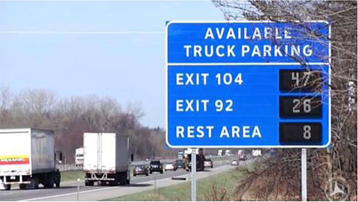
- Truck Parking Information Management Systems (TPIMS) - Real-time parking information is made available using data from sensors at public rest areas or commercial truck stops using upstream dynamic message signs, in-cab routing systems, smartphone applications, and traveler information websites. TPIMS helps to maximize available parking capacity and allow drivers to proactively plan their routes and make safer, smarter parking decisions. An example of TPIMS dynamic message sign is shown in Figure 11.
FHWA Office of Operations Active Parking Management website: https://ops.fhwa.dot.gov/atdm/approaches/apm.htm
Slide 41:
Other Applications and Modes
Author’s Slide 41 meeting notes below:
This is an example of a Truck Parking Information Management System Sign in Wisconsin.
Slide 42:
Other Applications and Modes
Active Transportation and Micromobility
- Micromobility - refers to several different modes of human and electric-powered transport that are low-speed (comparable to a bicycle), small, lightweight, and typically used for short distance trips
Examples
- Bikes
- Ebikes
- Electric scooters
- Electric skateboards
- Share bikes
- Electric pedal assisted (pedelec) bikes
- Other variations
Author’s Slide 42 meeting notes below:
Active transportation, micromobility, and their use of ITS to support better TSMO are an area of rapid change. Efforts to provide last mile human powered connectivity also has tremendous positive public health benefits. Micromobility refers to several different modes of human and electric-powered transport that are low-speed (comparable to a bicycle), small, lightweight, and typically used for short distance trips. Micromobility includes bikes, ebikes, electric scooters, electric skateboards, share bikes, electric pedal assisted (pedelec) bikes, and other variations that meet the criteria definition.
Examples of ITS-based active transportation and micromobility include:
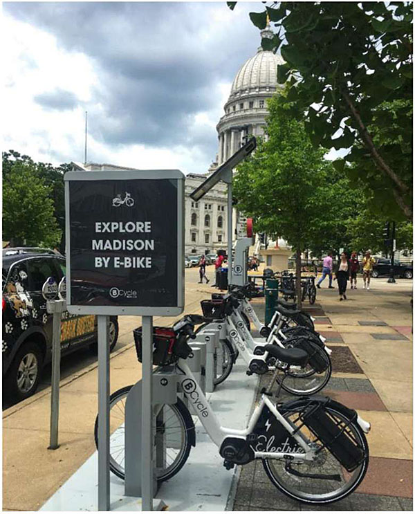
- Bike Sharing Programs - These come in the form of docked or dockless. Docked sharing programs require the rider to pick up and drop off the bike at a designated location. Dockless programs allow bikes to be parked anywhere. Equipped with GPS, the bikes can be tracked by the company who routinely drives around to collect the bikes and bring them back to popular rental locations (e.g., transit stations, special events, etc.). One area of increased popularity are e-bikes. Pedaling an e-bike is easier than riding a normal bike and makes cycling more accessible, especially in communities with hilly terrain. Figure 12 shows a sample of an e-bike sharing location.
- E-Scooter Sharing Programs - Predominantly dockless and equipped with GPS, the scooters can be tracked by the company who routinely drives around to collect scooters, charge them, and transport them back to popular rental locations (e.g., transit stations, special events, etc.).
Slide 43:
Other Applications and Modes
Author’s Slide 43 meeting notes below:
This is a picture in Madison, WI. It was the first bike share system in the country to convert to all e-bikes (Trek Bicycle Headquarters are nearby) in 2019.
Slide 44:
Other Applications and Modes
Smart City/Smart Community Applications
- Smart Infrastructure
- Smart Environment
- Smart Public Safety
- Smart Government
Freight - covered in another module
Transit - covered in another module
Author’s Slide 44 meeting notes below:
Smart City/Smart Community Applications
Smart city applications are geared toward leveraging technology, and specifically the Internet of Things (IoT), to make communities operate more efficiently while promoting sustainable development. ITS and TSMO fall under the category of smart mobility. Other categories that have a connection to transportation include:
- Smart Infrastructure - This includes intelligent LED lighting, public wi-fi, community interconnectivity, and smart cards that can be used for variety of services.
- Smart Environment - This includes air quality monitoring, green energy, and green urban planning.
- Smart Public Safety - Camera surveillance and NextGen 911 are examples of smart public safety.
- Smart Government - This includes open data portals, data eco systems, customer relations management, digital permits, and asset management systems.
Freight
Management of freight movement through technology can help improve TSMO. For example, by providing situational awareness of where oversize/overweight permitted loads may conflict with construction lane width restrictions can avoid loads getting stuck in work zones. Applications of virtual weigh in motion systems can help protect infrastructure on known bypass routes when nearby safety and weight enforcement facilities are open. Freight-based ITS, such as dynamic mobility applications, asset tracking, safety inspection, and onboard monitoring are covered in Module 6.
Transit
Transit technology has a significant role to play in TSMO. For example, broad use of real-time automated passenger counter information can inform better decisions related to integrated corridor management, and transit signal priority can help improve the rate of corridor throughput. Integrated fare payment systems can make travel across modes more convenient, more sustainable, grow ridership, and improve equity. Transit-based ITS, such as in-vehicle technologies, integrated fare payment systems, and multimodal trip planning applications are covered in Module 7.
Slide 45:
Emerging Technologies
- Edge Computing Transportation Applications
- Predictive traffic signal operations
- Improved localized weather condition detection
- Improved video analytics
- ATMS Hardware in the Loop/Near Real-Time Simulation
- Connected and automated vehicles
Author’s Slide 45 meeting notes below:
Edge Computing Transportation Applications
Edge computing takes computation power and data storage and places it in the field close to where operations are taking place. Edge computing reduces the burden of having robust communications to support centralized processing. It also helps provide a balance between bandwidth, security, latency, and cost at the edge verses big data analytics on agency-owned IT infrastructure or in the Cloud. Examples of existing and potential edge computing in ITS include:
- Predictive traffic signal operations.
- Improved localized weather condition detection (e.g., fog).
- Improved video analytics.
- Connected and automated vehicles.
As improved wireless telecommunications networks start to become more ubiquitous, the potential for connecting edge computing capabilities offers great opportunities for improving transportation management.
ATMS Hardware in the Loop/ Near Real-Time Simulation
With increased computing power, the ability to use real-time data from traffic detectors to feed into simulation software is being used to predict future traffic conditions. Several companies have developed commercial ATMS products that integrate hardware in the loop with rapid simulation software to help make better operations decisions.
Artificial Intelligence in Transportation
Artificial Intelligence (AI) has been increasingly integrated into the tools and techniques of the transportation industry. AI holds promise to improve capacity limitations, safety, reliability, environmental quality, and energy efficiency. More recently, critical operations related to automated vehicles and dynamic traffic control devices have included elements of AI. The public demands a certain level of guaranteed safety and reliability of AI-enabled systems.
Connected and Automated Vehicles
Connected and automated vehicle ITS, such as vehicle-to-vehicle (V2V), vehicle-to-infrastructure (V2I), vehicle-to-everything (V2X), and several other highway automation applications are covered in Module 13.
Slide 46:
Emerging Technologies
Artificial Intelligence
Artificial Intelligence
| AI Function |
Transportation Uses |
| Clustering |
Identifying specific classes of drivers based on driver behavior. |
| Control Functions |
Signal control of traffic at road intersections, ramp metering on freeways, dynamic route guidance, and traffic flow harmonization. |
| Decision Making |
Deciding whether to build a new road, how much money should be allocated to maintenance and rehabilitation activities and which road segments or bridges to maintain, and whether to divert traffic to an alternative route during a traffic incident. |
| Deep Learning |
Video detection analytics and short-term traffic prediction. |
| Nonlinear Prediction |
Traffic demand modeling; modeling the transportation infrastructure health as a function of traffic, construction, and weathering. |
| Pattern Recognition |
Automatic incident detection, image processing for traffic data collection. |
| Planning |
Support simulation and activity-based models. |
Author’s Slide 46 meeting notes below:
This Table highlights existing and future uses of AI in many areas of transportation, including ITS and TSMO.
Slide 47:
Emerging Technologies
Unmanned Aerial System (UAS) Applications for TSMO
- Accelerated crash investigation - photogrammetry and mapping
- Improved real-time situational awareness
- High-definition video and photography
- Sensors-traffic, heat, motion, electronic signals, etc.
- Relay to TMC and others
- Safety service patrol tethered monitoring for queue and alternate route monitoring
- Guided mobile data collection
Author’s Slide 47 meeting notes below:
This is an image of an UAS crash investigation by Iowa State Patrol along I-80 just outside Des Moines.
Unmanned Aerial System (UAS) Applications for TSMO
Unmanned aerial systems as a tool for TIM and improved situational awareness have been making their way into transportation. Based on a 2019 AASHTO survey, conducted over a three-year period, DOTs experienced rapid adoption of UAS for a variety of activities. In an earlier 2016 survey, there were no DOTs using UAS in daily operations. Today, approximately three quarters of State DOTs use UAS for routine work functions with the top uses being for video capture, surveying, and infrastructure inspection. This adoption is extremely fast for transportation agencies, who traditionally have been slower in adapting to emerging technologies. Building on the rapid rate of adoption, the business case for using UAS in TIM is also growing. For example, some areas are using UAS for large incident scene management and situational awareness and will likely incorporate their use into routine TIM investigations and supplement current training programs.
This picture shows an example of how UAS has helped in crash investigation.
AASHTO Journal, AASHTO Survey Finds Drone Use Exploding Among State DOTs https://aashtojournal.org/2019/05/24/aashto-survey-finds-drone-use-exploding-among-state-dots/
Slide 48:
Workforce Management and Development
To meet existing and future needs
- Need to evolve existing positions
- Rethink types of positions transportation agencies hire
- A TSMO Workforce Development Guidebook was published as part of an NCHRP project in 2019 to look at the types of positions transportation agencies need to start considering
Author’s Slide 48 meeting notes below:
As transportation agencies continue to evolve from infrastructure building to balanced management and operations organizations with an increased focus on TSMO, there is a need to attract, retain and evolve not only traditional positions such as traffic engineers and transportation planners, but also recognize the need for a more technically diverse workforce. A more diverse workforce needs to have expertise to support emerging technologies such as connected and automated vehicles, big data analytics, and sophisticated decision support systems. The TSMO activities of government agencies will need to change dramatically because of the increasing rate of transportation technology.
A TSMO Workforce Development Guidebook was published as part of an NCHRP project in 2019. The guidebook focuses on defining professional positions transportation agencies should consider as they mature their TSMO operations. The guidebook characterizes the TSMO workforce into professional and paraprofessional categories.
NCHRP 20-07/Task 408, TSMO Workforce: Skills, Positions, Recruitment, Retention, and Career Development: https://apps.trb.org/cmsfeed/TRBNetProjectDisplay.asp?ProjectID=4326
Slide 49:
Workforce Management and Development
Professional Position
| Traffic Data Scientist/Statistician |
Cyber Security Engineer |
| TSMO Manager/Chief/Bureau Director |
Transportation Data Ethicist |
| TSMO Program Manager |
Surface Weather Specialist |
| Computer Engineer |
Systems Engineer |
| Artificial Intelligence Scientist |
TSMO Modeling Specialist |
| Telecommunications Engineer |
Emerging Technologies Industry Liaison |
| Data Management Specialist |
Trans. Systems Performance Manager |
| Visualization Specialist |
Integrated Corridor Management Manager |
| Connected and Automated Vehicles (CAV) Program Manager |
Transportation Management Center Manager |
| Traffic Incident Management (TIM) Program Manager |
Author’s Slide 49 meeting notes below:
- Traffic Data Scientist/Statistician - An added emphasis on data science is required as very large amounts of data are becoming more important in making better operations decisions.
- TSMO Manager/Chief/Bureau Director - As TSMO is elevated in government agencies, roles and responsibilities of higher-level executive management are required.
- TSMO Program Manager - Several early adopters of TSMO have created Program Manager positions to coordinate across the wide array of functional areas and to implement activities that require a broad range of internal and external stakeholders.
- Computer Engineer - Specialized computer engineering is required as processing becomes more distributed where more and more operational decisions are made through edge computing in the field versus a centralized model.
- Artificial Intelligence (AI) Scientist - Government agencies currently have very little experience with AI, but this will rapidly increase as cooperative automated transportation becomes more broadly deployed.
- Telecommunications Engineer - As private and public communication networks become more ubiquitous and the bandwidth required for emerging technologies increases, staff that can navigate how to design the best ways to communicate with fixed and mobile assets will become more critical.
- Data Management Specialist - As a compliment to computer engineers and data scientists, data management specialists are responsible for curating data in a way that ensures a high level of reliability and accuracy.
- Visualization Specialist - With the output from the analysis performed by data scientists, visualizing large amounts of data in a way that is easy to understand becomes important as the information is used to make better operational decisions and to demonstrate the benefits of TSMO.
- CAV Program Manager - Many government agencies have hired Program Managers to work on issues related to developing the organizations’ capacity to support CAV technologies through research, testing, and partnerships with industry.
- TIM Program Manager - Working with partners to improve responses to traffic incidents is critical to driving down clearance times and secondary crashes. The best programs around the country have varying levels of participation from the local to statewide levels.
- Cyber Security Engineer - Cyber security is a growing concern as Internet of Things (IoT), Smart Community and CAV technologies propagate along transportation networks.
- Transportation Data Ethicist - The most forward looking of all the positions, these staff will be dedicated to making sure data is being used for the right reasons and all data is properly anonymized.
- Surface Weather Specialist - As climate change continues to impact the transportation network, engaging weather specialists with a TMC environment will aid in understanding the impacts and improving responses.
- Systems Engineer - As software, hardware, and communications networks become more complicated, having expertise on how all the pieces interact with one another will become even more critical.
- TSMO Modeling Specialist - As ICM strategies become more prevalent, the need for staff with advanced modeling and simulation skillsets for planning for operations and assessing impacts is critical.
- Emerging Technologies Industry Liaison - Several organizations have identified a need to hire an industry liaison to facilitate local private sector technology companies working with government agencies, recognizing the direct benefits of new approaches to solving problems and a less direct economic development impact.
- Transportation Systems Performance Manager - Telling the story of how the transportation system is functioning, both in real-time and over a period, has been critical to demonstrating the benefits of TSMO. A performance manager sees the big picture and can demonstrate the collective benefits of the various functions of TSMO.
- Integrated Corridor Management Manager - As management of freeways and arterial networks converge, dedicating staff to oversee the strategies across facilities that promote safety while improving corridor-wide mobility is increasingly important.
- Traffic Management Center Manager - While many government agencies have TMC managers that oversee staff in reacting to incidents and other events, the growth of technologies such as ATDM, ICM, and CAV within a control room environment will require an added level of sophistication and understanding of how different actions impact network operations.
Slide 50:
Workforce Management and Development
Paraprofessional Positions
- TMC Operators
- TMC Operations Supervisors (non-degreed)
- Safety Service Patrol Staff
- ITS Maintenance Staff
- Roadway Maintenance Staff
- Major Roadway Traffic Incident Support Staff
Author’s Slide 50 meeting notes below:
A TSMO paraprofessional is a position supporting the management and operations of transportation infrastructure. A TSMO paraprofessional may exert a high level of judgment in the performance of their work. TSMO paraprofessionals can comprehend and apply knowledge of basic engineering principles in the solution of broadly defined TSMO problems at a cursory level. TSMO paraprofessionals provide traffic management center operations services and a variety of TSMO field services.
Paraprofessional Positions
Examples of TSMO paraprofessionals include the following six positions:
- TMC Operators - Perform visual inspection of roadways through cameras, communicate with responders in the field via radio, communicate and coordinate with other agencies, receive phone calls from citizens, and monitor sensors collecting traffic volumes, speeds, travel times, integration of information technology (IT) services, etc. TMC operators also post messages on dynamic message signs, adjust ramp metering systems, implement traffic signal timing plans, update 511 website, or dispatch safety service patrol vehicles.
- TMC Operations Supervisors (non-degreed) - Responsible for overseeing TMC operators and serves as a main point of contact with professional staff.
- Safety Service Patrol Staff - Drive vehicles and aid motorists by providing basic services and repairs. Also provide temporary traffic control and back of queue awareness.
- ITS Maintenance Staff - Provide support in keeping ITS field equipment functioning. Requires strong knowledge on controller technology, communications, and sensors.
- Roadway Maintenance Staff - Play a key role in supporting long-term incident response.
- Major Roadway Traffic Incident Support Staff - Provides coordination of transportation resources during major traffic incidents.
White Paper: TSMO Paraprofessional Workforce Development, National Operations Center of Excellence: https://transportationops.org
Slide 51:
Future Considerations
- Alternative business models to maintain the latest technology
- Continued compression of agency staffing and need for new partnerships
- New ways to plan, fund, and program ITS to support TSMO strategies
- Expanding use of ITS to leverage its data to generate critical output metrics for TSMO performance management
- Developing novel approaches to making the business case for ITS
Author’s Slide 51 meeting notes below:
ITS plays a significant role in enabling and maturing TSMO throughout transportation organizations and helps to provide better network performance through a variety of strategies. While this module focused on a wide range of ITS tools, it is important to recognize the people, planning, policies, procedures, and collaboration required to gain maximum benefit from their use. With rapid and accelerating technology, it is critical that transportation organizations evolve existing positions and create new ones to meet the specialized needs of emerging technologies.
Future considerations for ITS and TSMO include:
- Alternative business models to maintain the latest technology.
- Continued compression of public transportation agency staffing and associated need to provide unique staffing strategies that blend public, private, and academic sectors.
- New ways to plan, fund, and program ITS to support TSMO strategies and approaches, especially moving to the next evolution of technology.
- Expanding use of ITS architecture and systems engineering to leverage ITS data to generate critical output metrics for TSMO performance management to justify use and management of ITS for TSMO.
- Developing novel approaches to making the business case for ITS supporting TSMO throughout the organization and with external partners.
Slide 52:
Future Considerations
- Impacts of connected vehicle technologies which will drive more vehicle-to-infrastructure interactions
- New modes of transit and improvements to existing service including rapid growth of transit hubs with seamless transfer between modes
- Innovations in micromobility and last-mile connections
- AI-augmented mobility applications
- Increased demand for robust cyber security
- TSMO’s growing role in freight management and operations
Slide 53:
Summary
- ITS plays a significant role in enabling and maturing TSMO throughout transportation organizations
- ITS helps to provide better network performance through a variety of strategies
- While module focus was primarily on ITS - important to recognize the people, planning, policies, procedures, and collaboration required to gain maximum benefit
- With rapid and accelerating technology, critical transportation organizations evolve existing positions and create new ones to meet needs
Author’s Slide 53 meeting notes below:
- Impacts of connected vehicle technologies which will drive more vehicle to infrastructure interactions.
- New modes of transit and improvements to existing service including rapid growth of transit hubs with seamless transfer between modes.
- Innovations in micromobility and last-mile connections.
- AI-augmented mobility applications.
- Increased demand for robust cyber security.
- TSMO’s growing role in freight management and operations.
Slide 54:
References
- FHWA Planning “What is TSMO?” website
- FHWA Human Factors Guidelines for Transportation Management Centers, 2018.
- FHWA Connected Vehicle Applications Automated Traffic Signal Performance Measures Case Studies: Utah Department of Transportation
- FHWA Transportation Asset Management Plans Case Study 7 - “Managing Assets Beyond Pavements and Bridges,” FHWA-HIF-20-067:
- Planning and Implementing Multimodal, Integrated Corridor Management: Guidebook, Web-Only Document 287
- Integrated Corridor Management (ICM) Program: Major Achievements, Key Findings, and Outlook:
- Federal Transit Administration, “Dallas ICM Transit Vehicle Real-time Data Demonstration: Final Report,” 2015.
- U.S. DOT Fact Sheet, “10 Attributes of a Successful ICM Site,” 2019.
Slide 55:
References
- FHWA Office of Operations Active Parking Management website: “Artificial Intelligence in Transportation - Current and Future Business-Use Applications.”
- AASHTO Journal, “AASHTO Survey Finds Drone Use Exploding Among State DOTs,” May 2019.
- NCHRP 20-07/Task 408, TSMO Workforce: Skills, Positions, Recruitment, Retention, and Career Development
- National Operations Center of Excellence, White Paper: “TSMO Paraprofessional Workforce Development,” November 2019.
Slide 56:
Questions
Todd Szymkowski
tszymkowski@gfnet.com
608.572.4755
Return to top ↑