A major component of the Wyoming Department of Transportation (WYDOT)-led Connected Vehicle (CV) Pilot is the Situation Data Exchange (SDX) that was developed by WYDOT-partner Trihydro based on the USDOT’s Situation Data Warehouse (SDW). A data retention and distribution source at its core, the SDX is available to any state or local agency to transmit Traveler Information Messages (TIMs) to CVs and is currently used by Wyoming, Colorado, and California. The TIMs contain information related to inclement weather warnings and advisories, recommended speeds, road closure notifications, parking/services information for trucks, and vehicle restrictions. Key to the SDX is its use of satellite communications, eliminating the need for roadside units and allowing WYDOT to have statewide TIM coverage, including remote areas. The TIMs help provide the necessary weather warnings and advisories along Wyoming’s 402-mile stretch of I-80 that is known for its harsh winter weather conditions. During the winter season − which for Wyoming can be more than half of the year − high winds, blowing snow, and severely reduced visibility force frequent road closures along the corridor (Figure 1).

Figure 1: Queue of trucks in inclement weather on I-80 (Source: WYDOT).
Though navigation apps are sophisticated enough to automatically re-route drivers based on road closures detected by probe information, the road closure information is not always up to date. Further, the navigation apps do not convey to drivers the often unmaintained and worsening conditions of the suggested alternative routes. As a result, drivers following navigation apps around closures in winter conditions can find themselves in dangerous situations where they get stranded without fuel, food, or water. This also creates hazards for the Wyoming Highway Patrol troopers and emergency responders tasked with locating and rescuing these motorists. The road closures from just one storm in 2023 resulted in 28 search and rescue missions by the one county in Wyoming (Sweetwater County Government, Wyoming) (Figure 2).

Figure 2: Blizzard conditions along I-80 can leave motorists stranded if the proper precautions are not taken (Source: Kandis Fritz).
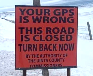
To warn drivers about misguided navigation data, WYDOT and counties within Wyoming began putting up signs to warn motorists that their GPS navigation apps may not be up to date and to state the road’s closure status in an explicit way (Figure 3). However, WYDOT knew it would be most prudent to warn drivers before they even got to this point and decided to tackle the issue directly at its source: the mapping apps themselves.

Figure 3: Posted signs warn drivers of road closures where GPS may not be reliable (Source: Wake Up Wyoming).
WYDOT began reaching out to navigation companies directly to see what could be done. Following talks with Google where WYDOT was able to show the traveler information data they had in the SDX, Google entered into an agreement with Trihydro to be a third-party distributor of the SDX data through Google Maps. To ensure they were providing Google with the best data possible, WYDOT consulted with the individual counties in the State to identify which county roads are not suitable for travel when an adjacent State-maintained road closes, including information on conditional roadway closures (e.g., seasonal, local traffic only, no trailer traffic, etc.). Acting as the aggregator, WYDOT has compiled all of the individual county closure data into a backend database hosted by WYDOT. The system even has a layer of built-in logic that determines, based on what major road is closed, what the likely cascading closures of adjacent roads will be. When a road is then marked as closed, all closure information, including the county roads that are closed due to a primary road closure, is pushed to the SDX. Google is then able to directly pull the closure data from the SDX and integrate it into their mapping and navigation feeds. WYDOT is also working with Google to distribute information about targeted closures for certain classes of vehicles based on size restrictions. For example, on a particularly windy day, WYDOT may want to close roads to vehicles under a certain weight (e.g., vehicles under 50,000 lbs.).
Video: WYDOT is working to make third party travel information more accurate (Source: WYDOT).
Previously, many of the counties did not have the resources to digitally disseminate information about road closures to travelers. Through this synergistic effort, WYDOT is able to provide a centralized data feed for statewide closure information that third parties can consume, helping the counties keep their travelers better informed and preventing them from being guided down impassable roads.
“WYDOT has collaborated with Trihydro’s Situation Data Exchange (SDX) Team to design and implement an exemplary messaging system that maximizes coordination between Wyoming’s jurisdictional levels and navigation companies to create and relay road incident updates and closures. The SDX provides Wyoming's high-quality data in the desired format through a convenient interface, all of which reduces Google Maps’ effort to acquire and translate Wyoming’s road incident updates into its navigation database. It’s been a pleasure working with the WYDOT and Trihydro teams to both understand and encourage their motivations and capabilities.”
− Eric Kolb, GIS Senior Staff Data Engineer, Google Maps
The traveler information communicated via the SDX will also help as Wyoming prepares for the 2024 Camporee, where over 60,000 people are expected to embark on Wyoming’s high plains for a week of camping and scouting activities. Looking ahead, WYDOT is hoping to finalize agreements to feed their mapping data into many other popular GPS navigation systems, including Apple maps, to ensure that users of all navigation apps can have access to the most accurate and up-to-date localized travel information possible.