ITS ePrimer
Module 14: ITS in Emergencies and Disasters
Authored by Christopher Poe, Ph.D., P.E. and Lee Mixon, P.E., Mixon Hill, Overland Park, KS, USA
2021
Table of Contents
Purpose
The purpose of Module 14 is to provide basic information on how intelligent transportation systems (ITS) can support transportation operations during emergencies and disasters. It looks at operational resilience, emergency transportation operations (ETO), and traffic incident management (TIM) as they relate to ITS.
ITS has historically supported transportation systems management and operations (TSMO) functions of a transportation agency. ETO and TIM are fundamental functions of TSMO and ITS is instrumental in delivering ETO and TIM services. This module introduces ETO and TIM and discusses how they support transportation operational resilience.
There are two aspects of operational resilience. The first aspect is that the transportation system needs to be resilient to incidents and events that could impact mobility and safety. The second aspect is that ITS needs to be resilient to support TSMO, ETO, and TIM. For example, ITS equipment and systems need to be designed and maintained to be functional when they are needed most during incidents and events. This module also explores ITS infrastructure resilience and the use of ITS to support response and recovery in emergency operations and traffic incidents.
Return to top ↑
Objectives
This module introduces operational resilience, highlights how ETO and TIM support operational resilience of the transportation system, and identifies strategies that support operational resilience of the transportation network, which includes maintaining resilience of ITS. The specific objectives of this module are the following:
- Define operational resilience as it relates to ITS
- Identify basic technologies and applications involved with ETO and TIM functions
- Identify how to make ITS infrastructure and systems resilient to natural and human caused events
- Identify how to use ITS to make the transportation system more resilient to changes in nonrecurring events (e.g., incidents, emergencies, and disasters) and use ITS to detect and respond to the impacts of these events
- Identify how ITS can support ETO and TIM for greater operational resilience
This module starts with an introduction to the concepts of operational resilience, ETO, and TIM. The next section introduces trends that will influence operational resilience and how agencies deliver ETO and TIM. This discussion is followed by individual sections that provide detail on operational resilience, ETO, TIM, and other non-recurrent / planned special events. These sections are followed by a system on the importance of systems and automation to operational resilience. The next section is on the needs and challenges to ITS, ETO, and TIM personnel. The final section is a summary and thoughts on future considerations.
Return to top ↑
Introduction
It is important to have a common understanding of terminology related to operational resilience, ETO, and TIM for further discussion in this module. The following defines these key concepts.
Operational Resilience
At the federal level, the Federal Emergency Management Administration’s (FEMA) vision under the U.S. Department of Homeland Security (DHS) is “A prepared and resilient Nation.” That includes a culture of preparedness and the ability to deliver integrated preparedness solutions to help people before, during, and after disasters. Within transportation, the U.S. Department of Transportation’s (U.S. DOT) Federal Highway Administration (FHWA) issued Order 5520 with the definition of operational resilience as “the ability to anticipate, prepare for and adapt to changing conditions and withstand, respond to and recover rapidly from disruptions.”
The Transportation Research Board (TRB) Operational Resilient ETO Subcommittee (ACP10-1) of the Standing Committee on Regional TSMO uses the definition for resilience from the National Academy of Science (NAS) of “the ability to prepare and plan for, absorb, recover from, or more successfully adapt to actual or potential adverse events.” What is important about both definitions is the proactive position where agencies can plan and prepare for events as well as maintain operations during and recovery from these events.
To be able to maintain operations during an event, it is important that ITS is available for use in unexpected events that might threaten ITS infrastructure and systems. Operational resilience includes “the ability of an organization to continue to provide business services in the face of adverse operational events by anticipating, preventing, recovering from, and adapting to such events.” Transportation infrastructure owners and operators (IOOs) can be public or private entities that either own or are responsible for the operation of transportation infrastructure (e.g., state departments of transportation (DOTs), transit agencies, toll road authorities, county DOTs, city DOTs, ferry operators, etc.) Infrastructure owners and operators provide key business services such as roadway and bridge operations, traffic signal system operations, and traveler information. During an adverse event, these services must still be available to users of the transportation system at some level to maintain mobility and safety.
It is also important to remember that transportation operational resilience applies to “people, process, and technology.” These are three pillars to operational resilience shown in Figure 1. To deliver ITS, it takes people and technology systems working together. However, people and technology cannot perform without the supporting policy, standard operating procedures, memoranda of understanding (MOUs), agreements, and guidance to enable them. Operational resilience must consider that people need all the tools at any given time to perform their job functions and make the entire transportation system work. Increasingly important is access to data and information to help ITS professionals do their job. This module examines automation and how systems can assist people in their ITS roles.
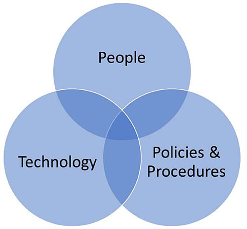
Figure 1. Fundamental Pillars for Operational Resilience.
Emergency Transportation Operations (ETO)
ETO responds to events, both natural and human produced, that require extensive, often multiagency, response and resources. These events can range as follows:
- Major traffic incidents
- Planned special events
- HazMat incidents
- Wildfires
- Major storms
- Malevolent acts
ETO, as well as most TIM response, uses the National Incident Management System (NIMS) to functionally organize its response. The major functions are as follows:
- Command and management
- Preparedness
- Resource management
- Communication and information management
- Supporting technologies
- Ongoing program management & maintenance
As shown in Figure 2, the U.S. DOT describes ETO as a continuum of efforts ranging from high probability-low severity events to high severity-low probability events. The transportation management and operational strategies under ETO can range from incident management to evacuation for major events. Planned special events, including work zones to major entertainment events, can also range in severity from a lane closed on a local street to attracting the threat of a malevolent act at a major entertainment event. With proper planning, demand management, and operation, motorists’ safety and mobility can be maintained during these events. Well-designed and maintained ITS can be an instrumental part of the response to any of these events.
Early ITS allowed agencies to collect data through roadway sensors and command and control field devices such as dynamic message signs (DMS), lane control signs, and conduct surveillance on transportation operations through closed-circuit television (CCTV) cameras. Intelligent transportation systems, combined with asset management and internet-of-things (IoT), has a broader impact on all aspects of a transportation agency’s business functions (planning, design, construction, operations, and maintenance).
Emergency transportation operations and TIM are components of TSMO that make transportation systems more operationally resilient. Recurring traffic, incidents, and planned special events impact the operations of a transportation system. Effectively-designed and operated ETO and TIM programs make that transportation system more resilient by restoring the transportation network to normal conditions in a timely fashion after such events.
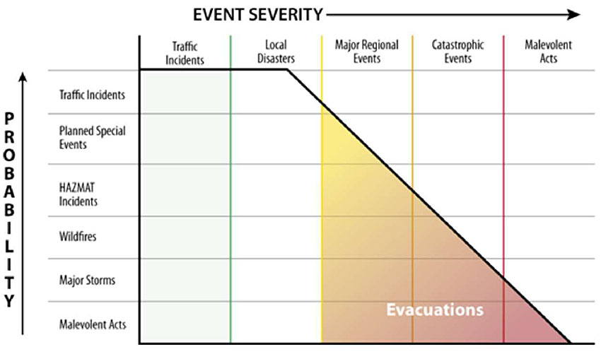
Figure 2. ETO Event Severity versus Probability. Source: U.S. DOT.
New threats, both natural and human made, are impacting the ability of transportation agencies to keep transportation systems operating at a high level. ITS and TSMO strategies are used to support ETO and TIM. The following are some examples of possible strategies:
- Work zone management (real-time location and monitoring of work zones)
- Planned special event management (advanced planning and strategies for known events)
- Road weather management (RWIS, environmental sensors, automate vehicle location for winter weather maintenance vehicles)
- Traveler information service (511 systems, traveler information websites, media alerts)
- Traffic signal coordination (signal phase and timing for improved corridor operation)
- Ramp management (detection and metering to manage local and corridor traffic)
- Active transportation and demand management (variable speed limits, dynamic lane and shoulder use, real-time alternate routing)
- Integrated corridor management (freeway, arterial, and transit strategies deployed cooperatively to maximize corridor throughput, mobility, and safety)
- Connected and automated vehicle (CAV) deployment (vehicle-to-infrastructure (V2I) and vehicle-to-everything (V2X) applications to alert vehicles and drivers)
In addition, there are examples of technology and data strategies to support ETO and TIM. These include the following:
- Interoperable voice communications
- Redundant data and communication networks to support ITS
- Remote access to data and ITS
Traffic Incident Management (TIM)
The U.S. DOT’s 2000 Traffic Incident Management Handbook (TIM Handbook) defined an incident as “any non-recurring event that causes a reduction of roadway capacity or an abnormal increase in demand. Such events include traffic crashes, disabled vehicles, spilled cargo, highway maintenance and reconstruction projects, and special non-emergency events.” Incidents are common, daily occurrences and have been estimated to account for approximately half of all traffic congestion nationwide. One of the most common types of incidents impacting mobility and safety is highway crashes. In 2018, there were a total of 6.734 million highway crashes in the U.S. This definition included other types of incidents that are less common but can take considerably more resources for response.
The 2010 update to the TIM Handbook goes beyond the original TIM Handbook to recognize that natural and human-made events need to be part of this incident definition, and that these larger, longer-lasting events tend to involve ETO and emergency response. Events like September 11, 2001, hurricanes along the Gulf Coast and East Coast, tornadoes in the Midwest, and forest fires in the west have shown that a broad range of response agencies (such as federal and state emergency management and response agencies and security agencies) should be included in these larger events.
The severity of an incident will dictate what is needed in terms of magnitude of response. John Contestabile highlights, in a paper prepared for the U.S. DHS, an incident scale and example responses for incidents classified as local, regional, state, and national. The more severe incidents typically have a longer duration and need greater interoperability and data sharing among multiple agencies. Figure 3 shows this incident scale, with example incident types and expected event durations.
To respond to such incidents, TIM is the structured, programmatic approach to reduce the impacts of incidents on the transportation system. TIM consists of a planned and coordinated multi-disciplinary process to detect, verify, respond to, and clear traffic incidents so that traffic flow may be restored as safely and quickly as possible. Another key component is providing traveler information to inform the partner agencies and general public of the location, duration, and impacts of an incident.
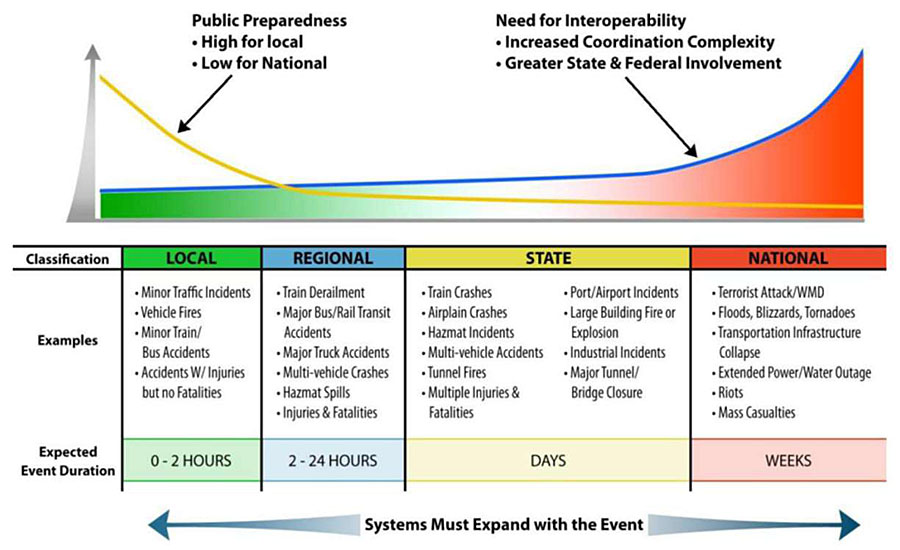
Figure 3. Incident Scale. Source: Johns Hopkins University Applied Physics Laboratory.
Figure 4 shows the incident timeline starting when an incident occurs at time zero (T0) through to when traffic returns to normal flow (T7). It also defines the detection time (T1-T0), verification time (T2-T1), response time (T4-T2), roadway clearance time (T5-T1), and incident clearance time (T6-T1). One key to minimize these times is real-time situational awareness. Real-time situational awareness refers to the knowing conditions of the transportation network. ITS is important in determining road conditions, traffic congestion levels, and incident occurrences and locations. Real-time situational awareness also refers to knowing the conditions and location of resources needed for emergency and incident response (e.g., materials, people, and vehicles).
As part of continuous improvement, two other key components of TIM are performance measurement and training. For performance measures, FHWA promotes the following four national TIM measures: roadway clearance time, incident clearance time, secondary crashes, and responders struck at incident scene. The measurement of the first two are shown in Figure 4. The goal is to collect data to allow calculation of these measures and strive to improve performance over time.
For training, it is important to educate incident responders and reinforce recommended practices for existing TIM personnel. The Federal Highway Administration and its partners have created the National TIM Responder Training Program to have TIM best practices taught by responders to other responders. As part of this program, FHWA tracks how many responders nationwide have taken the TIM training developed under the second Strategic Highway Research Program (SHRP2) program and works to publicize its availability and encourage its use. The goal is to train response personnel, their managers, and the executives responsible for TIM programs.
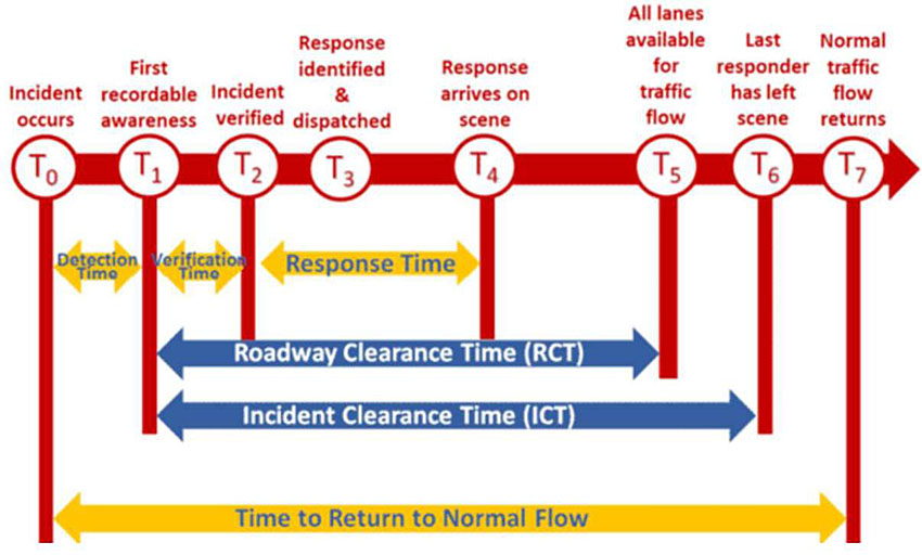
Figure 4. Incident Timeline. Source: Federal Highway Administration.
TIM’s multi-disciplinary approach involves a number of public and private sector partners, including the following:
- Transportation IOOs
- Law enforcement
- Fire and rescue
- Emergency medical services
- Coroners and medical examiners
- Emergency management
- Towing and recovery
- Hazardous materials contractors
- Public safety communications
- Traffic information media
- Public works
Intelligent transportation systems, such as detection, surveillance, and communications technologies, are used daily in state, regional, and local transportation operations to detect, respond to, and clear incidents to restore the transportation system to normal conditions. Elements such as transportation management centers (TMCs), state or local service patrols, multi-agency TIM training, laws to support TIM (e.g., Quick Clearance and Move-Over laws), programs to support TIM (e.g., incentivized towing to reduce towing response times), and policies and procedures all contribute to a successful TIM program. Intelligent transportation systems and successful TIM programs work together to improve the operational resilience of the transportation system.
Effective TIM reduces the duration and impacts of traffic incidents, which subsequently reduce the exposure and improve the safety of motorists, crash victims, and emergency responders. Quick clearance reduces the frequency of secondary crashes. Deployment of TIM strategies have the potential to reduce congestion, including decreased fuel consumption, reduced emissions, reduced travel times, and reduced vehicle operation costs. Well-coordinated TIM can reduce the resources needed in overall response and reduce the time required for all TIM partners through automated communication. Traffic incident management also can improve customer satisfaction for the agencies providing TIM services and heighten drivers’ confidence in the agencies and the transportation system.
Return to top ↑
Transportation Trends Impacting Use of ITS for Operational Resilience, ETO, and TIM
There are many trends in the transportation industry that are impacting operational resilience, ETO, and TIM. Those trends include climate change, travel demand growth, transportation funding, technology automation, and emerging and alternate transportation technology.
Climate Change
One of the greatest threats to operational resilience is climate change. Most scientists around the world agree that the effects of climate change are the result of human-caused actions and there is strong evidence for long-term trends of more extreme weather events being caused by climate change. Climate change has resulted in more frequent and higher-intensity weather events across the globe. The types of climate impacts include increase in very hot days, rising sea levels, increases in intense precipitation events, increase in drought conditions, and increase in hurricane intensity. The ability of transportation agencies to effectively manage, operate, and maintain a safe, reliable, transportation system is being threatened by a changing climate. Some of the impacts on transportation from those climate change impacts are the following:15
- Softening and buckling of pavements
- Buckling of rail track for heavy and light rail
- Overheating of vehicles
- Limitations on when construction / maintenance activities can be conducted
- Flooding of coastal roads, tunnels, and rail lines from rising water
- Flooding of inland transportation infrastructure from heavy rains and snow melt
- Erosion of road base and bridge supports (scouring)
- Increase in weather-related delays and traffic disruptions
- Increase in wildfires impacting visibility for drivers and closing roads
- More frequent, and potentially extensive, emergency evacuations
- Impacts to port and ferry terminals and operation
In states along the East Coast and Gulf Coast, hurricane frequency and severity are increasing with climate change. The resulting flooding from such storms can greatly impact the transportation infrastructure. An example of complete loss of roadway capacity as a result of hurricane flooding in Houston, Texas is shown in Figure 5.
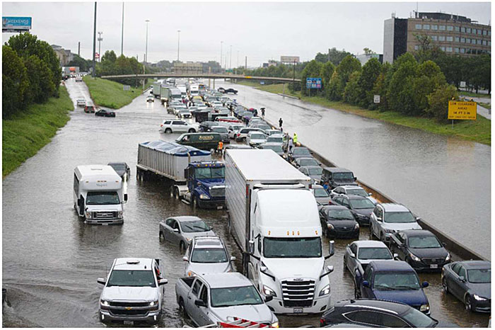
Figure 5. Hurricane Flooding Impacts on Transportation. Source: Sean Hannon acritelyphoto / Shutterstock.com.
Those impacts on transportation lead to impacts in how transportation agencies manage their transportation networks. Some of the operational considerations to counter transportation impacts of climate change include the following: 15
- Increase in traffic incident management activities
- Road and lane closures
- Reduced (and variable) speed limit
- Disruption of transit service
- Road and transit diversions
- Truck restrictions
- Work zone management (to accommodate additional lane closures)
- Adding sensors to alert operating/maintenance/response agencies when flooding is likely/imminent
Increasing Transportation Demand
Another trend is continued growth in transportation demand, especially in urban areas. Transportation demand is influenced by many factors, some of which are correlated with each other. For example, travel demand is influenced by the economy and the cost of fuel. At the same time, the economy and cost of fuel have interdependencies. Travel demand is also affected by outside influences such as natural and human made events. Figure 6 shows how vehicle miles of travel (VMT) have continued to increase for the past two decades, with an average annual rate of increase 1.1 percent between 2000 and 2019. The graph in Figure 6 also shows the decrease in 2008 which can be attributed to the economic recession and the subsequent increase due to the economic recovery in the following years. The last year of the graph shows the dramatic change in demand caused by the 2020 COVID-19 pandemic. In both cases, demand returned and continued to grow.
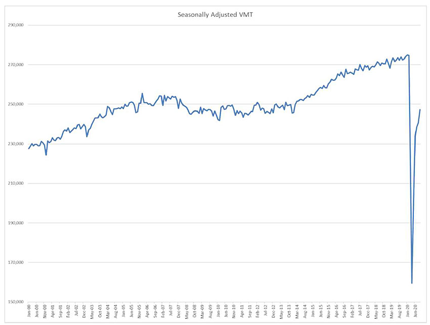
Figure 6. U.S. Vehicle Miles of Travel (2000-2020). Source: U.S. DOT.
Increases in VMT can lead to increased congestion, especially with no new capacity or changes in TSMO strategies. Texas A&M Transportation Institute’s 2019 Urban Mobility Report revealed that congestion caused 8.8 billion hours of delay and 3.3 billion gallons of extra fuel consumption for a total congestion cost in the U.S. of $179 billion. High congestion levels can lead to an increase in traffic incidents. As congestion and traffic incidents increase, ETO and TIM programs become more important to maintain and restore system efficiency.
Big Data
One role of ITS is to collect vehicle data. As VMT increases, that means more data. Another trend is “big data” and the collection, storage, and use of more data. The term big data is used to describe large and complex data sets. As more vehicles are connected, that results in more probe data to be used in real-time and to be stored for data analytics. As sensor and communication technologies enable IoT, more devices are connected to ITS, resulting in more real-time command, control, and monitoring of these devices. Transportation infrastructure owners and operators must be prepared to develop systems that can utilize growth and availability of data to enrich ETO and TIM programs.
The Transportation Research Board published NCHRP 904 on Leveraging Big Data to Improve TIM. The report recommends the following guidelines for transportation professionals to prepare TIM for big data:
- Adopt a deeper and broader perspective on data use
- Collect more data, process the data, and manage the data differently
- Open and share data
- Use a common data storage environment
- Adopt cloud technologies for the storage and retrieval of data
- Open and share outcomes and products to foster data user communities
Harris County Motorist Assistance Program
Innovative funding program by Metropolitan Transit Authority of Harris County (METRO), Texas Department of Transportation, Houston Automobile Dealers Association, and Verizon wireless to provide assist stranded motorist by providing fuel, water, air, minor repair to stranded motorists. At no cost to motorists, the public can call 713-CALLMAP or dial *627 (MAP) from a Verizon phone to request assistance. (Photo courtesy of Houston METRO.)
Transportation Funding
A further trend is the ongoing need for transportation funding. Transportation funding is challenged by several factors, including decreases in gas consumption due to electric/hybrid vehicles and no increase in the federal gas tax since 1991. Constrained and reduced budgets at federal, state, and local levels pose a challenge for transportation agencies in planning, designing, constructing, operating, and maintaining transportation systems. These fiscal constraints further challenge having sufficient funding needed for ITS and delivering TSMO. Securing funding for TSMO programs in general, and TIM/ETO in particular, is sometimes difficult because there is often no ribbon-cutting type ceremony that draws political attention to the benefits of the project.
At the same time, ITS and TSMO costs are a fraction of the total cost of constructing transportation projects. An intelligent transportation system can protect those transportation investments by preserving transportation capacity and operation during non-recurring events. With challenges in funding, agencies have found ways to support their ITS, ETO, and TIM programs. The metropolitan planning organization (MPO) in urban areas with populations greater than 200,000 has access to funding through a variety of federal programs to help fund ITS and TSMO. Some of these federal programs include Congestion Mitigation/Air Quality, Highway Safety Improvement Program, National Highway Performance Program, and the Surface Transportation Program. While all MPOs have these programs available for transportation funding, FHWA produced a report with specific case studies on nine regions using funding for TSMO activities in Denver CO, Rochester NY, Phoenix AZ, Orlando FL, Dallas/Fort Worth TX, Seattle WA, Washington DC, and San Diego CA. There are also some alternate funding sources that have been used to cover ETO and TIM activities. An example is in Harris County, TX where the Motorist Assistance Program (MAP) is operated at no cost to the county or motorists. During the week from Monday to Friday between 6 a.m. and 10 p.m., MAP personnel will change flat tires, supply fuel/water, jump start vehicles, assist with minor repair, and remove stranded vehicles from the roadway. This program is private sector sponsored by the Houston Automobile Dealers Association and Verizon Wireless. Another example is the State Farm Assist Patrol where State Farm is a program sponsor to more than 20 motorists assist patrols across the country. These patrols aid those who have been in accidents, offer help for debris removal, and to stranded motorists.
Illinois Tollway Authority
At the onset of the 2020 Covid-19 Pandemic, the Illinois Tollway Authority temporarily implemented All-Electronic Tolling (AET) as a precaution to the spread of the coronavirus. Toll booths at mainline toll plaza were taken offline and toll payment machines at ramps and mainline plazas were deactivated. Toll collection was entirely handed with I-PASS and E-ZPASS transponders with support of the Tollway’s online customer portal. The Tollway continued to operate their traffic operations center, maintenance teams, and HELP truck motorist assistance operations.
Workforce and Automation
Those same funding challenges put strains on transportation agencies to develop and grow an ITS and TSMO workforce. As shown in previously in Figure 1, people, technology, and policies/procedures need to work together to support operational resilience. Having a well-trained and equipped workforce that understands technology, policies, and procedures is critical to supporting operational resilience and delivering ETO and TIM programs. Transportation at university academic programs has traditionally been housed in the civil engineering and urban planning programs. To properly develop an ITS workforce, however, an agency needs to have a wide-range of knowledge in transportation engineering, electrical/electronic engineering, telecommunications, computer engineering, and information technology. As ITS and TSMO programs evolve, an agency may need additional knowledge, skills, and abilities in the areas of data science, artificial intelligence, cyber security, ethics, and statistics. These workforce needs cut across all areas of ITS. Emergency transportation operations and TIM programs also benefit from having knowledge of responders.
One approach to reducing some of the workforce needs is through automation. Automation of workflow processes and analysis is increasingly transforming workforce job positions with both positive and negative results. The positive results of automation include the removal of repetitive, monotonous tasks that can lead to reducing operator burnout, limiting the overload of information, and reducing the need for manual data entry during high-stress events. The negative result of automation is that it can lead to the elimination of various positions as technologies advance. The key to reducing the impacts of job elimination is to have training and transition plans in place to allow workers to transition into new positions with the appropriate skills and abilities. With automation, there is still a need for skilled staff that understand how these systems work and can verify the accuracy of the output.
An example of how automation aided transportation operations during the 2020 COVID-19 pandemic is through the expansion of all-electronic toll collection, as was done in Illinois. Manual toll collection is used to a greater extent in some regions of the country, but that practice causes social distancing challenges in times of a pandemic. While electronic toll collection has been in use in the U.S. for decades, the all-electronic tolling deployment was accelerated to reduce the person-to-person interaction in collecting cash payments on toll roads.
Alternate Transportation Services
A last trend emerging is alternate transportation services and business models. Higher precision and lower-cost vehicle sensor technology along with advanced control algorithms have led to advanced driver assistance systems (ADAS) and automated vehicles. This has the potential to lead to fleets of driverless vehicles that can deliver mobility in new ways. At the same time, there are mobility-on-demand (MOD) and mobility as a service (MaaS) offerings, such as Uber and Lyft, new micro-transit services and companies, as well as bike sharing and scooter programs. These new types of technologies and services need to be considered in operational resilience, ETO, and TIM. For example, if people are relying on these services for their mobility, will those same services be available during an evacuation for a catastrophic event? Additionally, connected vehicles offer new sources of probe data that may enhance incident detection and response and CAVs may allow improved dissemination of alternate route and diversion route information.
Return to top ↑
Operational Resilience
Transportation professionals are concerned with both the operational resilience of the transportation system and the operational resilience of ITS to support ETO and TIM during natural and human-made events.
Intelligent transportation systems are used to monitor, manage, operate, and respond to a wide variety of events. Some of those events can impact the ITS equipment and technologies being used. One example is telecommunication availability during an emergency event. The event can cause damage to communication infrastructure. Past examples such as the attacks on the World Trade Center on September 11, 2001 caused cell towers to be destroyed. The damaged infrastructure puts additional strain on the remaining wireless network. This can result in outages that prevent ITS devices on wireless networks to communicate which can further restrict how the public receives traveler information from wireless devices. Similarly, flooding events can cause harm to electronic infrastructure such as traffic sensors, DMS, and traffic signal systems. Events such as Hurricane Katrina in 2005 saw flooding that caused damage to infrastructure, resulting in traffic detectors and traffic signals malfunctions.
One way to prepare for such events is to implement a continuous and proactive program that anticipates the capacity and functions needed during these events. The Federal Highway Administration has developed a Climate Change and Extreme Weather Vulnerability framework that can help an agency institutionalize operational resilience due to events resulting from causes such as climate change. The framework provides an overview of how ITS and TSMO professionals can begin to act through the following steps:
- Define the scope of the vulnerability assessment, including key variables, program objectives, and relevant assets
- Assess vulnerabilities through data collection, asset performance, risk assessment, and ratings/prioritization to inform the development of strategies
- Integrate strategies into agency decision making
- Monitor and revise processes
- Some of the strategies to support this overall framework include the following:
- Adding redundancy (i.e., duplication of critical components or systems to ensure continuity and increase reliability) to the assets or systems (e.g., network, power, etc.)
- Having backup (i.e., copies or spare parts to replace loss) components available at the device and system level (e.g., data, field devices, etc.)
- Allowing for substitution of component or devices
- Designing or redesigning to reduce or eliminate vulnerabilities of products and processes
- Having the flexibility to improvise during incidents and events to make use of on-hand resources (human or material)
- Allowing for priority access for responders
- Modeling disruptions and system operation
- Planning for back up logistics to truly be able to implement backups and substitutions when the time comes
- Regularly run scenario tests to check equipment and system capabilities
Another area of operational resilience for ITS is security. Cybersecurity is a growing concern of IT and ITS professionals trying to maintain a secure, operational, and resilient network. ITS needs to have cybersecurity considerations built into the design and operation of systems and devices to ensure operational resilience. Many of the strategies to mitigate cybersecurity threats follow good information technology best practices. Transportation agencies and their contractors should do the following:
- Keep software regularly updated and upgraded
- Implement user access management policies and procedures on all accounts
- Implement device and data access management policies
- Maintain a system and data recovery plan
- Actively manage systems and configurations
- Proactively detect network intrusions
- Leverage hardware security features
- Segregate critical networks and services
- Integrate threat reputation services
- Implement multi-factor authentication
The IT systems at other TIM/ETO agencies should also follow these practices to ensure resilience is maintained across agencies and the transportation network.
An example of design of security into a system is in the area of CAVs. The U.S. DOT has led an effort to develop a Security Credential Management System (SCMS) to ensure connected vehicles operate in a safe and secure environment where privacy of personal information is protected. Companies now offer SCMS solutions to IOOs deploying CAV environments to securely generate and distribute vehicle-to-vehicle (V2V) and V2I message certificates directly to vehicle and roadside infrastructure devices. These certificates are managed by the SCMS and new certificates can be registered and distributed as needed. The concern is that a “bad actor” could introduce a message into the system with ill intent. The objective of the SMCS is to identify messages being sent by vehicles or devices that do not have a proper certificate and prevent those messages from entering the system; thus, preventing any information that cause harm to people, infrastructure, data, or systems.
The corresponding personnel, physical systems, and policy measures need to work in a cohesive framework to ensure this operational resilience. Security is only as good as its weakest link. ITS/TMC staff and TIM/ETO responders should be aware of and follow their agency’s security policies and procedures.
Intelligent transportation systems are moving to greater system interoperability for agencies to gain situational awareness and coordinate interagency response; however, this system interoperability introduces additional security risk. Intelligent transportation systems, , ETO, and TIM professionals should understand the security policies and procedures of their partner agencies to ensure that everyone works as an integrated team. Agencies should provide initial and continual training to reduce the risk of security breaches and keep security in front of mind of all ITS, ETO, and TIM personnel.
Operational resilience also needs to be considered in the design, installation, and maintenance of ITS infrastructure. Intelligent transportation system infrastructure elements include traffic sensors, traffic signal systems, CCTV cameras, DMSs, ramp meters, highway advisory radios (HARs), road weather information systems (RWIS), automated/semi-automated directional gates, networking equipment, and TMCs. Real-time transportation system operation requires accurate inventory of all ITS infrastructure and software used in operations; ITS should work with an agency’s asset management system to ensure command, control, and troubleshooting of ITS infrastructure.
Best practices should be constructed to make sure ITS field staff can safely maintain field devices by placing them in locations with good access and protected from traffic. Additionally, continuous monitoring should be conducted to make sure ITS elements are communicating and the devices are properly performing. If any problems or outages are detected, a regular maintenance program should ensure the device is repaired, replaced, and returned to operational condition. Much of this can be automated so that ITS is continuously monitoring and alerting ITS staff when actions need to be taken. Those ITS staff should have the ability to monitor remotely from where they are physically located at the time of the event. Web-based platforms and applications allow ITS staff to view camera images, data, and maps from remote work locations or the field.
EOC and Fusion Centers
A critical part of ETO is the establishment of temporary or permanent emergency operations centers (EOCs). EOCs are focused on multi-agency response coordination and support emergency response, incident management, and recovery activities. Fusion centers provide a hub for sharing information to support terrorism response, crime prevention, and public safety response across multiple agencies representing multiple jurisdictions.
Just as ITS/TSMO professionals have pushed for greater emphasis on operations over the last decade, there needs to be additional emphasis on policy, procedures, and funding to ensure continuity of operations during emergency events.
Additional best practices are needed to inform agencies on how to place ITS infrastructure to allow it to properly function during incidents and emergency events. It could be as simple as not placing critical ITS infrastructure where higher instances of incidents and crashes occur (e.g., the outside of a horizontal curve with a known run-off-the-road crash history). Alternately, practice could be locating critical ITS infrastructure outside of flood areas or at elevation above anticipated flood levels to ensure continuous operation. Greater use of automated or semi-automated reversible lanes, shoulder lanes, directional gates, and cross overs may be needed to allow rapid use or reuse of transportation infrastructure during events. Virtual and redundant systems for TMCs are also required to account for physical and geographic constraints that cannot be overcome but also lead to network or system failures.
Return to top ↑
Emergency Transportation Operations (ETO)
Emergency transportation operation tends to focus on the larger unplanned events, also known as “no notice” events. Unplanned events could be natural disasters (e.g., wildfires, floods, tornadoes) or human caused events (e.g., malevolent acts, terrorist attacks). These types of events may require advance evacuation (e.g., hurricane evacuation may start several days in advance) or real-time evacuation (i.e., wildfire may speed up or change direction causing immediate evacuation) to get people out of harm’s way.
The intelligent transportation system can be instrumental in facilitating evacuations; it can provide real-time situational awareness of availability of roadway infrastructure and traffic conditions on those routes and can inform traffic management, law enforcement, and ETO staff through collection of traffic condition data or images or video of real-time conditions. Traffic and surveillance data can assist with decision making processes in setting up detours and alternate routes. Intelligent transportation systems can also be helpful to the general public by providing traveler information on DMS and supplying traveler conditions and routing information to traveler information websites and applications.
At larger incidents, (e.g., hazardous material incidents, tornados), responders would use National Incident Management System Unified Command, which involves multi-agency and multi-jurisdictional approaches to incident and emergency responses. Unified Command is a structure that brings together the command leadership from the agencies involved in the incident in order to coordinate an effective response; coordination still allows the individual agencies to carry out their own jurisdictional, legal, and functional responsibilities. The on-scene presence of various responders is shown in Figure 7. A key component of Unified Command is the regular coordination to adjust the incident and response progresses. FEMA provides an online training course through its Emergency Management Institute (EMI).
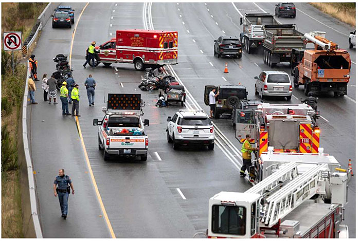
Figure 7. Emergency Transportation Operation at Incident Scene. Source: VDB Photos / Shutterstock.com.
Safety and efficiency of emergency responders are improved with interagency coordination of infrastructure systems. Infrastructure systems such as water and power may be needed as part of the response. Information on their location and availability could be time critical during a response. At the same time, location information may save lives by reducing the chance of a responder inadvertently being hurt. For example, knowing where sewer inlets and manholes are located during a flooding event is important to protect responders from these potentially dangerous conditions. Additionally, the location of powerline and power grid infrastructure (overhead or underground) is important in protecting responders from electrical dangers; knowing status is also critical. Responders need accurate information if power is on or if leaks are being detected (e.g., water or gas leaks). Making this type of coordination part of emergency response planning and training scenarios can help ensure smooth operation in the field during an actual event. For example, Washington State shares information to manage disasters and emergencies through an information management system. The system provides a platform to manage and share information from local, state, and federal agencies. It is a collaboration tool for a common operating picture for situational awareness. The system is part of the communications strategy outlined in the Washington State Comprehensive Emergency Management Plan.
Similarly, ITS allow for data to be connected from other systems and sensors to give responders needed information on weather, infrastructure, medical services, and health care systems. Interoperable communication allows for this information to be shared among the responding agencies. Insight on the progression or direction of weather events will aid in the emergency response. Input from bridge management, construction management, or maintenance management may inform or alter a response plan. An incident or emergency that involves significant injuries may benefit from knowledge of the health care system. If local emergency rooms are full or being inundated, information about emergency room capacity at neighboring hospitals will aid in getting timely medical treatment.
Technology Highlight - UAV
Unmanned Aerial Vehicles
(UAVs), frequently called drones, are increasingly being used by state and local transportation and emergency response agencies to assist with ETO and TIM. UAVs have the ability to provide a bird’s-eye perspective to give greater situational awareness of incidents and events. This perspective can also assist in accident reconstruction. UAVs can be supplied and operated by the responders (typically law enforcement), aviation departments within DOTS, or individual DOT personnel.
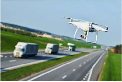
Source: Shutterstock.com
Emergency transportation operations staff need to be prepared to respond to multiple events happening concurrently. As the frequency of events increases, so does the probability that more than one event may occur at the same time. For example, a region may be carrying out a hurricane evacuation over several days leading up to the predicted land fall. During that time period, other events (e.g., major truck spill involving hazardous material on an evacuation route or a train derailment parallel to an evacuation route) may occur. The secondary event must be responded to and the primary hurricane evacuation must also continue with alternate routes to avoid the secondary incident. Emergency transportation operations and TIM responders need to have contingency plans based on possible scenarios.
Another tool to allow agencies to respond to multiple events is mutual aid; this is the reciprocal exchange of people and resources for mutual benefit. Often used in fire and law enforcement, one agency’s officers and equipment may respond to another agency’s jurisdiction. For example, in two neighboring cities, a fire engine from City A may be closer to an emergency in City B. With the proper mutual aid agreements and procedures in place, City A’s fire engine could start the initial response. The concept of mutual aid can be expanded to transportation and ITS. As emergency events/incidents impact multiple agencies and jurisdictions, there need to be plans and policies for sharing of ITS resources to support response.
Return to top ↑
Traffic Incident Management
There are many daily events that can reduce roadway capacity and restrict traffic flow, such stalled vehicles, crashes, roadway debris, roadway flooding, snow/ice, construction activity, and maintenance activity. Incidents are unplanned events that can cause partial or complete closure of a roadway.
Severity of incidents, the type of vehicles involved, the location, and physical constraints of incidents can now be anticipated based on advanced analytical and historical patterns of incident locations and point-in-time conditions.
Maricopa County, Arizona - REACT
In Maricopa County, Arizona, the arterials comprise nearly 3/4ths of the region’s lane miles and 2/3rds of all travel in the greater Phoenix region. The Regional Emergency Action Coordination Team (REACT) provides assistance to local agencies within Maricopa County for incident management that impacts arterial roadways. Participating Arizona jurisdictions are Scottsdale, Avondale, Tolleson, Glendale, Peoria, and Surprise.
The key to identifying and managing these events is having good situational awareness. The use of ITS devices to gather data improves situational awareness by collecting and reporting real-time information. Traffic sensors on the roadway system collect speed, volume, and density of traffic data. Detection of atypical traffic patterns can be an indication of an incident; IOOs may also use third-party traffic provider data consisting of probe vehicle data.
There are many technologies emerging to improve operational situational awareness, including connected and automated vehicle (CAV) video analytics, infrared camera technology, and unmanned aerial vehicles (UAVs); CAVs offer additional probe vehicles in the traffic stream. Research is ongoing about how to use speed, heading, and location data from CAVs to enhance traffic management strategies such as ETO and TIM.
Video analytics are also improving as machine vision algorithms continue to advance. Video technology is becoming more cost effective, localized data processing capability is becoming more efficient, and telecommunication is becoming more cost-effective and faster to transmit data. The video data can be used to automatically detect certain types of incidents like vehicles broken down on the roadside, stalled vehicles in traffic lanes, or crashes when certain vehicles are not moving in relationship to the other vehicles in the field of view. Video does not always work well under nighttime conditions and inclement weather. There are alternate technologies, such as infrared cameras, that are looking for the heat source on a vehicle. The heat source can be tracked by an infrared camera during daytime and nighttime conditions. To provide resilience, some redundancy in TIM technology may be needed under certain conditions to ensure that accurate, timely information can be collected during normal and event operations.
Traffic incident management response can be tailored to the severity and type of incidents expected on different functional classification of transportation system. For example, arterial and local roadway TIM practices are emerging in various locations throughout the country to complement existing TIM strategies on freeways and highways. Some local agencies have assistance for service patrol vehicles to respond to uniquely non-state highway and freeway facilities. Arterials and local streets tend to be in narrower rights-of-way. Thus, sizing DMS to fit in those rights-of-way with proper font sizes and number of lines of text for lower speed facilities allows for arterial-sized traveler information along routes with high-incident frequency or designation as an alternate route. An arterial incident scene is shown in Figure 8 with the additional complications of traffic signals, pedestrian and bicycle facilities, and narrower rights-of-way.
There are also strategies to provide greater safety and protection for the people and equipment at an incident scene or at a maintenance or construction job. Many response, construction, and maintenance vehicles are equipped with light bars; additionally, agency maintenance fleet vehicles can be equipped with on-vehicle arrow boards. Some agencies have developed specific protection vehicles with barriers creating a mobile environment that can be quickly dispatched and set up to protect workers. These vehicles can be manually operated or even automated for on-scene protection. Similarly, some agencies have pursued automated attenuator vehicles that can follow mobile operations without requiring a driver to be in the vehicle designed to protect responders/workers.
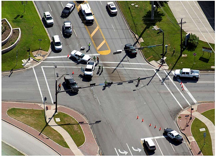
Figure 8. Incident on Arterial Roadway. Source: Texas A&M Transportation Institute.
The Federal Highway Administration supports the Every Day Counts (EDC) Program to assist state DOTs in deploying innovation for improved safety and mobility. The program has promoted several TIM initiatives over the past five years. The EDC-4 TIM initiative promoted using data to reduce roadway clearance time, incident clearance time, and secondary crashes by quantifying program effectiveness to improve TIM planning and execution. The EDC-5 TIM initiative focused on crowdsourced data to improve operations. By using crowdsourced data from social media platforms, third-party data, and purpose-developed mobile application data, TIM agencies can produce low-cost, high-quality data to improve transportation systems operations and TSMO strategies. The EDC-6 TIM initiative looked at combining technology, data, and training to create the next generation of TIM. By using technologies such as UAV and CAD (and the subsequently needed training), agencies have seen significant improvement in TIM activities.
In Maryland, the State Highway Administration (SHA) operates the Coordinated Highways Action Response Team (CHART). The Maryland SHA has used data from their TMCs to estimate the benefits of CHART operations. The total benefits from CHART operations from delay reduction, fuel consumption reduction, and emission reduction is estimated at $1.4 million.
Maryland TIM Benefits and Performance
In Maryland, the CHART operations have resulted in decreases in response time, decreases in incident clearance time, and decreases in secondary crashes. The findings from 2019 data found:
- Average incident duration was about 24 percent shorter (eight minutes shorter from the average of 33.91 minutes) with CHART response.
- The number of severe incidents blocking three or more lanes decreased five percent.
- The estimated number of secondary crashes was reduced by 365 crashes due to CHART’s contribution to shortening incident duration.
Return to top ↑
Non-Recurring, Planned Events
Crashes and incidents are unplanned, non-recurring events on the transportation system, meaning they do not occur regularly at the same time and location as peak period congestion. There are other types of nonrecurring events that are planned. The common types of planned, non-recurring events that impact transportation are construction activities, maintenance activities, and special events. These events will have different impacts on congestion depending on how much traffic flow restricts results. Whether the activities are off the roadway but within the right-of-way, on the shoulder, closing traffic lanes, or closing an entire roadway, those activities will have an impact on traffic congestion.
Figure 9 shows a major construction work zone set up during nighttime operation that closes a shoulder and lane on an Interstate highway.
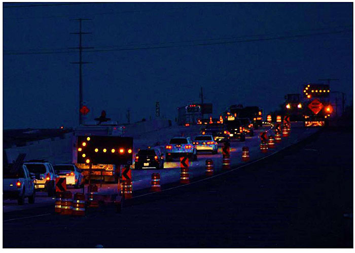
Figure 9. Work Zone with Traffic Control. Source: Texas A&M Transportation Institute.
Operational resilience is also about proactively planning for these situations. One of the key steps in preparing for these planned events is for the stakeholders to develop the desired level of performance of the transportation system during these events. Operators should establish a good baseline of the current transportation operations and performance (e.g., crash frequency, crash rates, speeds, travel times, throughput) prior to the event, if possible. Safety and mobility goals should be established for these non-recurrent events; these goals may vary by the severity of the event. For example, a major construction project that requires a road closure with a detour might set a goal of not creating more than 10-20 percent increase in travel time. Maintenance activities can be similar to construction work zones, but they often have less advance notice as they are reacting to needed repair of transportation infrastructure.
Traffic simulation tools (ranging from simple to more sophisticated simulations) can be used to test the operational strategies under various traffic demand levels to see if the plans for these events produce the desired results (e.g., Highway Capacity Manual-based tools, traffic signal optimization tools, macroscopic simulation tools, mesoscopic simulation tools, or microscopic simulation tools). Planned special events can include major events (e.g., Olympics, Super Bowl) to medium events (e.g., concerts, sporting events), to minor events (e.g., parade). The size of the event and anticipated severity of the impacts may dictate what level of planning and simulation is conducted.
Well-planned, organized, and publicized construction management, maintenance management, and special event management will maintain mobility and safety during these events. However, if operational strategies alone do not look like they will handle the performance goals, then travel demand management strategies may also be needed. For example, major events like the Olympics have discouraged local travelers from making discretionary trips during these events and even gone as far as encouraging area residents to take vacations or take time off work to lower travel demand. Other agencies have launched large-scale public outreach campaigns to warn of the potential impacts of an event. An example was in Los Angeles, California in 2011, when local agencies warned of “Carmageddon” if drivers did not stay away during the 10-mile freeway closure of the I-405. This campaign was successful in reducing travel demand during construction.
Based on the goals and the planning results, ITS infrastructure should be used to collect speed, volume, and travel time data to continuously measure the results of the operational plans for these events. Intelligent transportation system traveler information devices such as DMS can be used to provide alternate route and event timing information in support of travel diversion from the impacted facilities. Performance measures should be shared with the coordinating agencies and used to improve and fine-tune the operational strategies.
Any of these non-recurrent event situations can cause a reduction in capacity and increase the need for ETO and TIM programs to manage traffic when incidents happen during construction, maintenance, or special events. An incident or crash on a detour or alternate route around a planned event could greatly decrease the effectiveness of the operational plan. One of the key strategies is to clear incidents as quickly and safety as possible to restore the capacity on these routes. For planned events, this could include staging additional response personnel and tow truck operators at key locations in anticipation of incidents.
Representatives from all ETO and TIM agencies should be included in the planning stages for all planned events to ensure all stakeholders are aware of new plans, procedures, and strategies that will be used.
Return to top ↑
Role of Systems and Automation
The internet of things (IoT) describes the network of devices and infrastructure (i.e., “things”) that contain sensors, software, and other technologies for the purpose of connecting and exchanging data with other devices and systems over the Internet; IoT has the potential to provide more near real-time information about the condition of transportation assets. Historically, ITS uses roadway sensors to measure traffic volume, speed, and density; road weather sensors to gain temperature and precipitation readings; and flood sensors to monitor water depths. Low-cost sensors and communications allow instrumentation of additional roadway elements such as bridges, signs, guiderails, and various other roadway infrastructure. Additional sensors and wireless communication on agency fleet vehicles allow for continuous monitoring of the vehicles as mobile assets, as probes in the traffic stream, and as sensors on the roadways to collect additional data. All this instrumentation and data collection allows ITS professionals to know the continuous condition of all fixed and mobile assets on the transportation system. These data can be quality checked, stored, and made available for use in various applications.
Cloud-based solutions—either public or private cloud systems—can help move the data computing, memory, and storage needs to facilities that are removed from the threat of events. Separation of these systems in more secure locations adds to the resilience of the overall ITS.
These systems should incorporate both backup systems and disaster recovery systems and efforts should be made to assess which systems and/or database require redundancy. Ideally, the disaster recovery is stored at a separate site to further ensure protection of data and systems. More sophisticated systems will allow for real-time access to the backup and disaster recovery system to minimize downtime of the systems needed during incident and event response.
A system is only as reliable as its weakest link. This puts emphasis on needed resilient and redundant telecommunications to transmit the data. Wireline and wireless technologies for communication need to be examined in relation to the types of events in a region. Redundancy in the communication networks may be needed to ensure connectivity during incident and emergency events too. If a fiber optic communication link is lost, could a wireless communication link be established to bring basic data back to keep systems running? A wireless link in this example may be at reduced speed or bandwidth, but it may make the difference in being able to continue to operate during an event.
The intelligent transportation system has typically relied on operations staff in TMCs to monitor CCTV cameras, traffic condition displays, and alerts from advanced transportation management systems. However, as ITS expands and scales to cover more of the transportation system, it becomes more difficult for human operators to monitor the entire system. A TMC operator in front of the multitude of monitors bringing back images from the transportation system is shown in Figure 10. Thus, automation is becoming more important to conduct self-monitoring and self-reporting systems. These systems can notify TMC operations staff of what and when something needs to be done, including automatically monitoring the cybersecurity health of the systems used in operation.
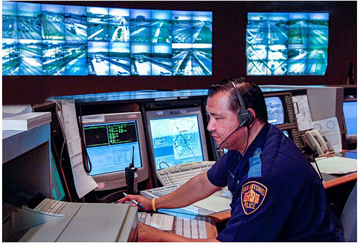
Figure 10. Transportation Management Center Personnel. Source: Texas A&M Transportation Institute.
Collaboration between ITS, ETO, and TIM personnel can be improved through TMC and public safety answer points (PSAPs) co-location, data integration, and voice integration to support response to unplanned events. Public safety answer points are the communication centers for public safety response agencies, receiving 911 calls, dispatching responders and resources, and monitoring incident communications. The TMC and PSAP function together to provide communications, data, resources, and situational awareness functions for incidents. The Transportation Safety Advancement Group (TSAG), on behalf of the U.S. DOT, developed a white paper on the integration of TMCs and PSAPs. Greater integration can be achieved through co-location, voice integration, data integration, and incident/event integration so that the two centers enhance and support incident response more effectively; both centers use communication and data systems. While TMCs generally run ATMS software to manage, command, and control ITS infrastructure, PSAPs run computer-aided dispatch (CAD) systems. Computer-aided dispatch systems are rarely integrated with TMCs to share data, making it difficult to enhance agency efficiency and response effectiveness. Geographic information systems (GIS) allow geographic data to be shared between agencies and systems by defining geographic features (e.g., jurisdictional boundaries, roads) for common use; an example is the Michigan Geographic Framework (MGF). By integrating the data between TMC and CAD systems, greater information can be achieved in both systems to aid in the dispatch and response to incidents and events. The potential benefits are faster notification of incidents, improved incident response, quicker clearance, reduced workload on responders, and enhanced situational awareness. The integration of the systems can create considerably more data, which creates the need for greater automation to monitor data and notify center personnel of alerts that need attention.
Technology Highlight - GIS
The Michigan Geographic Framework (MGF) is both a program and a product. The MGF product provides a digital base map of Michigan cities, villages, townships, counties, and minor civil divisions. The MGF allows users to obtain up-to-date accurate GIS data across the state. Much of the data in this map is provided thru the State of Michigan’s Open GIS Data Portal.
Source: Mixon/Hill, Inc.
Intelligent transportation systems can include decision support systems (DSSs), data analytics, and artificial intelligence to ingest more data and examine more operational strategies, including demand management strategies, operational strategies, and regional diversion routes. Decision support systems are a form of automation to build decision making into the operating systems. The U.S. DOT funded two Integrated Corridor Management (ICM) Deployments in Dallas, Texas and San Diego, California (selected from eight sites originally selected for developing ICM plans). Both the Dallas and San Diego sites included a DSS but implemented automation at different levels. In Dallas, the stakeholders used the DSS to bring back recommended ICM strategies to the TMC operator and required the TMC staff to manually implement new messages on DMS and new signal timing plans to implement the agreed upon strategy. In San Diego, the DSS could directly implement ICM strategies such as new signal timing plans if pre-determined operation rules were met.
Another form of automation is the use of artificial intelligence (AI) and machine learning. Machine learning uses computer algorithms to automatically learn and improve decision making through experience rather than explicitly being programmed. Various TSMO programs within IOOs have varying degrees of sophistication in how they use analytics and data to support agency decisions. For example, pavement management programs and planning processes within DOTs have a deep and extensive history in data-driven decision making. Gettman33 highlighted how Nevada and Florida DOTS are using AI for TIM. Both agencies have shown improvements in incident detection times using AI.
Another use of AI is in the planning for diversions for major events. Mukhopadhyay et.al showed how virtual reality could be used with subjects to understand the route choice during extreme events when the infrastructure is dynamically available. The researchers then trained augmented route choice models to take into consideration this learned behavior to predict behavior more accurately in the evacuation due to storms near I-10 in Louisiana.
Technology Highlight - Use of Artificial Intelligence
The Nevada and Florida DOTs have supplemented radar and loop detection of incidents with AI that processes video from CCTV cameras. The AI is trained to recognize “incidents” “likely incident,” and “non-incidents.” Both agencies have reported improvement in incident detection times of up to 12 minutes faster than traditional methods.
Return to top ↑
ITS, TSMO, ETO, TIM Personnel
The roles and responsibilities of ITS, TSMO, ETO, and TIM personnel across the county are evolving to support operational resilience. As ITS expands in size and coverage, it is more difficult for ITS operators to monitor all the data and information coming into a TMC. The advanced transportation management system (ATMS) is monitoring ITS data and using algorithms, DSSs, data predictive analytics, and even artificial intelligence to inform the TMC operator of conditions, proactive steps, and operational strategies.
Each day firefighters, emergency medical services, law enforcement, tow truck operators, construction workers, maintenance workers, and ITS personnel across the country are exposed to hazards and risks inherent in emergency responses on the nation’s highways and roadways. A core need is to keep these personnel safe, increase ETO and TIM performance, and improve operational resilience and multi-agency training.
Knowledge of emergency response and emergency operations is important to support ITS and TIM. Some state and local DOTs hire law enforcement and fire department personnel for their TIM programs. Some DOTs have found 9-1-1 call takers have the right skills and abilities to serve as TMC operators; hiring personnel with emergency response backgrounds assists in creating greater familiarity with all aspects of ETO and TIM.
Response personnel are typically equipped with radios and cell phones to allow for communication with command and dispatch. As ITS evolves to allow for low-cost, high-bandwidth communication, response personnel can also have web-based platforms and applications that allow for data to be presented to increase situational awareness from the field or remote locations.
Emergency transportation operations and TIM field staff are seeing additional responder safety initiatives to protect the individual workers on the roadway (or within the transportation right-of-way). Figure 11 shows a courtesy patrol worker operating near traffic to direct drivers away from an incident scene. New technologies are emerging to increase the safety of responders. With the low cost of sensors and wireless technologies, there is technology emerging to create connected responders that can both send data and receive alerts to add to their safety. Wearable devices that include sensors to measure environmental conditions, responder health status, and responder motion can be used to enhance responder safety. Responder-based systems are also being deployed that when activated will send drivers a notification through their navigation systems, in-vehicle displays, or mobile devices. Alerts will warn drivers in advance as they approach an emergency event near the roadway. Heads-up display technology is also being developed for responders and workers to provide assistance in executing their job responsibilities while offering a hands-free environment.
Additionally, there are technologies being developed and deployed to help provide on-scene protection and safety. On-scene, whether an incident scene or work zone area, intrusion alert systems can monitor if vehicles are encroaching on work zone areas and putting workers in danger. With the advancement of CAVs, vehicle location and heading data can be broadcast directly to responders and support vehicles on scene.
Return to top ↑
Summary and Future Considerations
State, regional, and local response agencies are increasingly becoming aware of the concepts of operational resilience and the tools to help anticipate, withstand, and recover from natural and human-made events. With the increase in events that can impact the transportation system, ITS and infrastructure need to be planned, designed, and deployed to help make these systems resilient to future events. In addition, ITS should be used to help operate and recover during these events; it should also consist of ETO and TIM programs that include planning, training, and executing response and evacuation procedures. These ETO and TIM programs should utilize ITS to assist with the detection, verification, response, recovery, and evaluation procedures to effectively handle incidents and events.
Technologies and systems are expanding and will continue to be enhanced to provide greater operational resilience for ITS, ETO, and TIM. One of the keys is greater integration of these systems across the agencies that are jointly responsible for ETO and TIM to improve response to incidents and emergency events. Additionally, emerging technologies will aid in the safety and speed of event response; some of those technologies include CAV technology, low-cost sensor technology, TMC and public safety integration of telecommunication technology, and responder personal protective equipment.
Expansion of ITS, both geographically and in scale of the infrastructure being instrumented, will generate considerably more information about an agency’s total assets. ITS will continue to see
an increase in automation that allows these systems to ingest vast amounts of data, self-monitor transportation assets, and bring actions and strategies forward to ITS staff for implementation in ETO and TIM. Where appropriate, these systems may automatically implement strategies. This will require more systems, devices, and machines to communicate with each other.
For those systems to be resilient, there must be the proper redundancy to ensure continuous and resilient operation, especially during the events these systems are deployed to help address. To improve operational resilience, ITS will need to expand redundancy in data sources, ITS, telecommunications, and even personnel. Proper use of backups, including data storage and equipment, will be needed to recover from data loss or equipment failures.
Transportation agencies will continue to face challenges from changing travel demand, natural and human-made events, available funding, and new technologies; ITS needs to be planned, designed, and deployed with an understanding that technologies will evolve. Agency policies, procedures, and core systems can be the foundation of ITS programs and continue to integrate new technology into those programs over time. Agencies with the mindset to be a leader in technology should invest in technology to demonstrate the safety, mobility, and financial benefits to the agency, transportation work force, and general public. Starting with pilot projects can determine initial benefits or potential risk which will inform future investment decisions. Those agencies not able to be at the leading edge can benefit from watching those other leading agencies and adopting best practices that emerge from their deployment.
Return to top ↑
Resources
The following resources provide more guidance on operational resilience, ETO, and TIM.
References
- Federal Highway Administration, Intelligent Transportation Systems for Traffic Incident Management, FHWA-JPO-07-001, U.S. DOT, January 2007.
- Federal Highway Administration, “Transportation Management Center Data Capture for Performance and Mobility Measures Reference Manual, Final Report,” FHWA-JPO-13-055, U.S. DOT, March 2013.
- Federal Highway Administration, “Transportation System Preparedness and Resilience to Climate Change and Extreme Weather Events,” Order 5520, U.S. DOT, December 2014.
- Federal Highway Administration, Traffic Incident Management Handbook, FHWA-HOP-10-013, U.S. DOT, January 2010.
- Federal Highway Administration, “2019 Traffic Incident Management Capability Maturity Self-Assessment National Analysis Report,” U.S. DOT, November 2019.
- Federal Highway Administration, Traffic Incident Management (TIM) Self-Assessment Guide, U.S. DOT, March 2004.
- Federal Highway Administration, Climate Change Adaption Guide for Transportation Systems Management, Operations, and Maintenance, FHWA-HOP-15-026, U.S. DOT, November 2015.
- Transportation Research Board, Transportation Systems Management and Operations Workforce Guidebook, NCHRP 20-07/Task 408, March 2019.
- Federal Highway Administration, “Simplified Guide to the Incident Command System for Transportation Professionals,” U.S. DOT, 2006.
- Federal Highway Administration, “Raising Awareness of Artificial Intelligence for Transportation System Management and Operations,” U.S. DOT, 2019.
- Federal Highway Administration, “Transportation System Resilience to Extreme Weather and Climate Change: Technical Staff Fact Sheet,” FHWA-HOP-15-025, U.S. DOT, November 2015.
- Transportation Research Board, “Leveraging Big Data to Improve Traffic Incident Management” NCHRP 904, Washington DC, 2019.
Websites
- National Operations Center of Excellence (NOCoE), www.transportationops.org
- Federal Emergency Management Agency Training, Emergency Management Institute, www.training.fema.gov/nims/
- Emergency Responder Safety Institute, https://www.respondersafety.com/
- SHRP2Solutions, Federal Highway Administration, National Tim Responder Training, https://www.fhwa.dot.gov/goshrp2/Solutions/Reliability/L12_L32A_L32B/National_Traffic_Incident_Management_Responder_Training_Program
- Federal Highway Administration, Emergency Transportation Operations for Disasters, https://ops.fhwa.dot.gov/tim/
- https://onlinepubs.trb.org/onlinepubs/conferences/2018/RISE/Presentations/P.Pisano.Capability_Maturity_Self-Assessment_Tools.FHWA.SilverRoom.09102018.pdf
- https://ops.fhwa.dot.gov/publications/publications.htm
Return to top ↑
Notes
1 Federal Emergency Management Agency, “2018-2022 Strategic Plan,” https://www.fema.gov/sites/default/files/2020-03/fema-strategic-plan_2018-2022.pdf.
2 Federal Highway Administration, “Transportation System Preparedness and Resilience to Climate Change and Extreme Weather Events,” Order 5520, U.S. DOT, December 2014.
3 National Research Council, NAS definition used by the TRB Committee on Operations Resilience Subcommittee. Disaster Resilience: A National Imperative2012
4^ Brandenburg, R., et al., “Striving for Operational Resilience,” Oliver Wyman, 2019.
5 https://blogs.gartner.com/andrew_white/2017/01/12/adding-data-to-people-process-and-technology/. Accessed November 2020.
6 Federal Highway Administration, U.S. DOT, https://ops.fhwa.dot.gov/tim/, accessed November 2020.
7 Federal Highway Administration, U.S. DOT, https://ops.fhwa.dot.gov/tim/, accessed November 2020.
8 Federal Highway Administration, Traffic Incident Management Handbook, FHWA-HOP-10-013, U.S. DOT, January 2010.
9 Bureau of Transportation Statics, https://www.bts.gov/content/transportation-accidents-mode, accessed November 2020.
10 Contestabile, John, “Concepts on Information Sharing and Interoperability,” Applied Physics Lab, Johns Hopkins University, 2011.
11 Federal Highway Administration, Intelligent Transportation Systems for Traffic Incident Management,FHWA-JPO-07-001, U.S. DOT, January 2007.
12 Federal Highway Administration, Transportation Management Center Data Capture for Performance and Mobility Measures Reference Manual, Final Report, FHWA-JPO-13-055, U.S. DOT, March 2013.
13 SHRP2 Traffic Incident Management Responder Training, https://www.fhwa.dot.gov/innovation/everydaycounts/edc-2/pdfs/edc_traffic.pdf.
14 Federal Highway Administration, User-Friendly Traffic Incident Management (TIM) Program Benefit-Cost Estimation Tool, FHWA-HRT-16-055, U.S. DOT, January 2016.
15 Transportation Research Board Special Task Force on Climate Change and Energy, Transportation Research Circular E-C152: Adapting Transportation to the Impacts of Climate Change State of the Practice 2011, June 2011.
16 United States Department of Transportation, Climate Change Adaptation Guide for Transportation Systems Management, Operations, and Maintenance, FHWA-HOP-15-026, November 2015.
17 Federal Highway Administration, Travel Monitoring, Traffic Volume Trends, September 2020 Monthly Report, U.S. DOT, https://www.fhwa.dot.gov/policyinformation/travel_monitoring/tvt.cfm, accessed December 2020.
18 Texas A&M Transportation Institute, 2019 Urban Mobility Report, Texas A&M University System, College Station, Texas, 2019.
19 Cambridge Systematics, Inc., “Traffic Congestion and Reliability: Trends and Advanced Strategies for Congestion Mitigation,” September 2005.
20> Transportation Research Board, Leveraging Big Data to Improve Traffic Incident Management NCHRP 904, Washington DC, 2019.
21 Federal Highway Administration, Programming for Operations: MPO Examples of Prioritizing and Funding Transportation System Management and Operations Strategies, U.S. DOT, September 2013.
22 https://www.assistpatrol.com/about. Accessed April 2021.
23 Transportation Research Board, Transportation Systems Management and Operations Workforce Guidebook, NCHRP 20-07/Task 408, March 2019.
24 Illinois Tollway Authority, http://archives.subscribermail.com/msg/43c347bc02b3471398e6f9ca20de27d8.htm, content no longer available.
25 Federal Highway Administration, Climate Change Adaption Guide for Transportation Systems Management, Operations, and Maintenance, FHWA-HOP-15-026, USDOT, November 2015.
26 National Security Agency, NSA’s Top Ten Cybersecurity Mitigation Strategies, https://www.nsa.gov/Portals/70/documents/what-we-do/cybersecurity/professional-resources/csi-nsas-top10-cybersecurity-mitigation-strategies.pdf. Accessed December 2020.
27 Federal Emergency Management Agency, Emergency Management Institute, www.training.fema.gov/nims/
28 Washington State, Comprehensive Emergency Management Plan, March 2019.
29 Hauser, Barbara, TMC Coordinator, Maricopa County, Presentation to the ITE Western District Annual Meeting, Phoenix, Arizona, https://www.westernite.org/annualmeetings/13_Phoenix/Presentations/Session%203B%20-%20Hauser.pdf, 2013.
30 Every Day Counts, Federal Highway Administration, https://www.fhwa.dot.gov/innovation/everydaycounts/.
31 “Performance Evaluation and Benefit Analysis for CHART in Year 2019,” State Highway Administration, Maryland DOT, University of Maryland, College Park, MD, October 2020.
32 Transportation Safety Advancement Group, TMC-PSAP Data Integration White Paper, October 2020, https://www.ite.org/technical-resources/topics/transportation-system-management-and-operations/transportation-safety-advancement-group/products/tmc-psap-data-integration-white-paper/, accessed December 2020.
33 Michigan Geographic Framework Documentation, https://www.michigan.gov/-/media/Project/Websites/dtmb/Services/GIS/CGI_frmwkdoc06.pdf?rev=94ecd44586dc42208a2ca86cf4f3be00.
34 Federal Highway Administration, “Raising Awareness of Artificial Intelligence for Transportation System Management and Operations,”, U.S. DOT, 2019.
35 Mukhopadhyay, S., Zhu, Y., and Gudishala, R., “Combining Virtual Reality and Machine Learning for Enhancing the Resiliency of Transportation Infrastructure in Extreme Events,” Tran-SET, Louisiana State University, September 2019.
Return to top ↑