ITS ePrimer
Module 5: ITS to Support Travelers
Authored by Alex Skabardonis, Professor and Research Engineer, University of California, Berkeley, Berkeley, California, USA
Table of Contents
Introduction
ITS technologies offer an array of applications and enhancements for multimodal transportation, from real time information to safety applications and driver conveniences. This module explores current and emerging applications that enhance traveler experience and safety.
Return to top ↑
Learning Objectives
- Learn the capabilities, features, and limitations of ITS technologies for multimodal transportation
- Understand deployment opportunities and constraints for ITS technologies for all travelers
- Understand how ITS personal transportation applications impact the user and the transportation system in terms of mobility and accessibility
- Understand emerging and future trends in ITS technologies for all travelers
Return to top ↑
Real Time Travel Information
Traveler information is one of the core concepts of ITS. Travelers value high-quality information in terms of expected travel times as well as reliability of travel times, easy and timely accessibility to that information, a high-quality user interface, and at low cost, preferably free. Consumer demand for traveler information is a function of the characteristics and the amount of congestion on the transportation network, availability of alternative routes, modes for individual trips, and traveler information characteristics such as information quality and user interface.
ITS applications providing traveler information can assist travelers prior to their trip or while en route. Pre-trip information includes traffic, transit and multimodal options, weather, incidents, and work zone information posted on Internet websites, television, radio, and mobile phone applications for users to make informed decisions for trip departure, route choice, and mode of travel. En route information, available via roadside or in-terminal message signs, in vehicle devices, wireless devices, and mobile phone applications, allows users to make informed decisions regarding alternate routes, mode, or travel options, as well as travel times.
Before the 1990s, traveler information dissemination was typically limited to existing media outlets such as television, radio, and newspapers; and field devices, such as variable message signs (VMS), and highway advisory radio (HAR) units. Although early attempts to communicate with travelers proved successful (e.g., the experimental route guidance system in Washington, DC in the late 1960s and the Pathfinder experiment in Los Angeles in the mid 1980s), limited off-the-shelf products or systems were available to travelers. In Europe and Japan, route guidance and information systems were also tested with real-time information displays on in-vehicle devices. Similar technologies were tested in the United States and proved effective pre-1990s; however, commercial products never reached the market. An assortment of telephone systems existed to provide regional or local travel information. Although the capabilities existed to disseminate travel information using telephone systems, wide-scale branding of a common phone number was lacking, and only a limited set of the population knew of the systems. The designation by the Federal Communications Commission (FCC) of the three-digit dialing code of 511 as the national traveler information phone number in 2000, and the financial support by the USDOT to states in launching 511 phone systems across the United States, has been successful.
The introduction of the Internet World Wide Web to the general population in the early 1990s allowed public agencies to create websites for dissemination of travel information in terms of real-time travel speeds on the network links plus images from surveillance cameras at critical transportation network locations that could be viewed by anyone at any Internet accessible location. It also allowed private sector information service providers to create local, regional, or nationwide traveler information systems. Wireless communications allow travelers to access web information from smartphones or through navigation apps.
Dissemination
Operation of these traveler information systems may be performed by either public or private agencies. Currently, travelers have a variety of sources from which they can receive traveler information, including the following:
- Publicly-operated 511 phone systems are available to anyone with access to a telephone; currently, there are publicly operated 511 phone systems in 46 states, offering coverage to 195 million Americans (70 percent of the population).
- Publicly-operated traveler information websites are available free of charge to users. Each of the 50 states offers some form of traveler information website.
- Field devices such as variable message signs (VMS) provide information to drivers on expected travel times for certain destinations and alerts on incidents, inclement weather, and other events. VMS are typically installed on freeways near major interchanges that provide opportunities for selecting alternate routes. Portable VMS signs are also used to provide information in case of major incidents, work zones, or special events. Electronic message signs (boards) at stations are used by transit agencies to relay real-time vehicle and route information to travelers.
- Private traveler information providers offer web, phone, or special devices (e.g., in-vehicle navigation systems or handheld devices) primarily in metropolitan areas; some products are now expanded to include rural areas.
- Privately operated news and media outlets disseminate traffic, weather, and event information over radio and television broadcasts with the majority of traffic and event information describing metropolitan areas.
The video in the following link illustrates how the West Michigan Traffic Operations Center (WMTOC) uses real-time traffic flow data to display real-time travel times on VMS throughout the Michigan Department of Transportation (MDOT) Grand Rapids Region and on the Mi Drive website. https://www.youtube.com/watch?v=tUNgPSx0rxk
VMS signs are also utilized to display information about crashes and lane blockages ahead. A study by the Ontario Ministry of Transportation showed that lane blockage warnings on VMS can reduce secondary crashes and improve safety [3]. Examples of emergency messages include AMBER (America’s missing: broadcast emergency response) alerts issued to notify the drivers about abductions of children, and LEO (law enforcement officer) alerts on VMS when a police officer has been injured or killed to disseminate this information to drivers in case they have any valuable information. A SILVER alert [17] is a public notification system to broadcast information about missing persons, especially senior citizens with Alzheimer’s disease, dementia, or other mental disabilities, in order to aid in locating them.
Deployment Tracking Survey data (Figure 1) [43,26,27] indicate that the Internet is the most common medium for traveler information dissemination and is used by nearly 89 percent of freeway management agencies, 40 percent of arterial agencies, and 85 percent of transit agencies. Email and text messaging also are common methods of distributing both pre-trip information (alerts to desktop, subscription services), and en route information (alerts to mobile devices). The next most widely-adopted traveler information technology includes 511 systems, which are used by approximately 60 percent of agencies. Slightly over 40 percent of agencies reported using social media and networking sites such as Twitter to distribute traveler information.
Social networking sites such as Waze—which is a route-planning mobile application for drivers—enriches the travel experience. Drivers share their experience as they travel on traffic routes. The data provided by Waze and other smartphone applications provide information for incidents and other events [1]. In case of congestion, the application recomputes alternative routes based on the shared information and informs the drivers. A potential downside of rerouting is the congestion caused to local roadways [6]. Further information on Waze and related community-driven applications is presented in Module 4 (ITS Data in Decision Making).
An important consideration in providing en route information to drivers is the possibility of causing driver distraction. Distracted drivers cause up to 30 percent of the 6 million automotive crashes in the United States. As more complex controls, displays, communications devices, and entertainment systems appear in cars, the level of driver distraction is expected to increase. Real-time information provided en route in the form of text messages or in-vehicle navigation systems may further increase driver distraction and information overload.
Ongoing research and development efforts focus on systems that integrate data from in-vehicle technologies and control the information flow to the driver through an adaptive driver-vehicle interface. The objective is to lower the frequency with which drivers multitask, reduce their exposure to risk, reduce the complexity of distracting tasks, and manage the multitasking options that drivers can make to avoid overloading them.
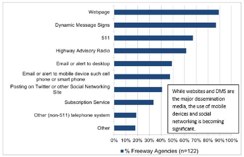
Figure 1. Methods of Traveler Information Dissemination [43].
Data Sources
Data sources for traveler information systems include fixed detectors, event information, and mobile sources:
- Fixed detectors are typically installed along each travel lane at approximately 0.5-mile intervals. These detectors provide traffic volume and speed data every 20-30 seconds. The data are sent to the transportation management centers (TMCs) where they are checked and aggregated into typically 5-minute values. They are used to produce color-coded speed maps, estimate travel times for certain origins, and destinations.
Fixed detectors are either embedded in the pavement (loop detectors and magnetometers) or mounted overhead or on the side of the road. Examples include microwave radar, video, laser, and ultrasonic detectors. Module 9, Supporting ITS Technologies, of this ITS Primer provides detailed coverage on vehicle detection.
- Incidents and other events are detected by police patrols, incident management teams, and automatic incident detection algorithms based on detector data. Incident information can also be obtained from cellular phone callers reporting events witnessed as they travel. Often closed circuit television (CCTV) cameras are the main source for incident verification by TMC staff.
- Mobile sources include probe data and compiled crowdsourcing information. Probe data from toll tags (transponders), and cellular phones. Such data can be used to estimate travel times between various points in the network. Bluetooth readers and personal and commercial in-vehicle navigation systems (e.g., delivery trucks) can be used to obtain travel times between fixed points. The widespread use of smart phones equipped with global positioning systems (GPS) has significantly increased the coverage and accuracy of data from mobile sources. An increased number of private vendors are working on data acquisition and marketing of data using mobile phones as probes.
Crowdsourced data may be generated anywhere people travel and have Internet access. Crowdsourced information is also timelier than agency-generated data due to the higher probability of travelers coming across an incident or encountering congestion than an agency detecting it via its sensors, cameras, and field patrols. Analytics provide a level of confidence that the reported incident type and location are accurate. The Waze data can be integrated with the data available TMCs to provide reliable travel time information, as shown in the Regional Integrated Transportation Information (RITIS) System website (Figure 2) [13].
Benefits
Evaluation of traveler information services [12,41] shows that these systems are well-received by those who use them. Benefits are found in the form of improved on-time reliability, better trip planning, and reduced early and late arrivals. The overall number of people who use traveler information on a daily basis represents a relatively small portion of travelers in a region; however, demand can be extremely high during periods of severe weather, emergencies, or special events. Traveler information systems during these periods have recorded extremely high usage. Studies indicate that traveler information can be very effective during periods of non-recurring congestion caused by unexpected events such as incidents. Although the estimated impacts are lower for transit traveler information compared to highway traveler information, simulation models indicate that up to up to 4 percent of travelers will shift to transit when adequate information is available [10, 45]; data reliability, however, is critical. In order to gain and maintain public trust, traveler information must be accurate. The Federal Highway Administration (FHWA) has recommended that traveler information such as travel time data be at least 80 to 90 percent accurate.
Past evaluations [41] show that the traveler information systems have positive impacts, mostly in the area of customer satisfaction (Figure 3). Travelers positively perceive the effectiveness of such systems in terms of mobility, efficiency, and customer satisfaction, even in cases where the absolute travel time savings are small. New applications for delivering traveler information through the mobile Internet and the effective integration of traveler information with network transportation management on freeways and arterial systems will increase the benefits of timely and accurate travel information.
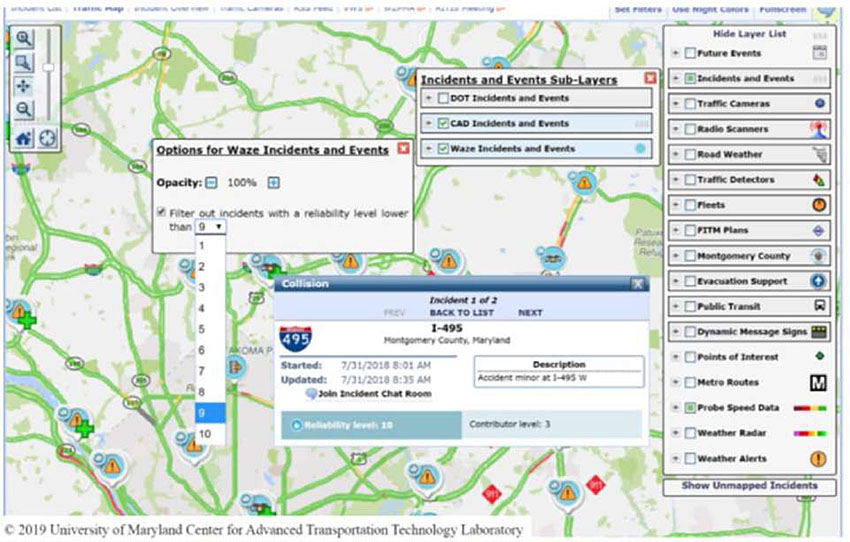
Figure 2. RITIS and Waze Data Integration [13].
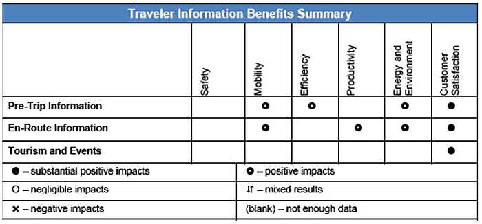
Figure 3. Benefits of Traveler Information Systems.
Transit
Transit-specific traveler information systems are operated by various public and private service providers. Transit traveler information systems range from human-operated phone systems to complex vehicle tracking systems tied to automated phone and Internet delivery systems or mobile app-based systems. The key elements of transit information systems technology and applications include information content (e.g., location of bus stops), information format (tables, maps, or text), and delivery media (print, online, VMS, and mobile devices). These systems also incorporate arrival and travel times, and in some cases other relevant information such as vehicle crowding. Table 5.1 below, adapted from a study by the USDOT Volpe National Transportation Center [14], shows a summary of transit information systems, uses, strategies, and levels of technology. Also shown are the trip stages for which each element is suitable, namely pre-trip (PT), en route (ER), at the station/stop (AS), and all (ALL).
Transit information systems are enhanced to include travel options for other travel modes. One example is with the Tri-County Metropolitan Transportation District of Oregon (Tri-Met). Tri-Met operates a real-time traveler information system for transit riders. The Tri-Met system open trip planner project (OTP) includes an online transit trip planner offering statewide transit trip planning services. Tri-Met tracks transit vehicles using automated vehicle location (AVL) and offers updated arrival and departure times on both the website and traveler information phone system. The updated Tri-Met OTP includes shared-use mobility (SUM) options, including bicycling, real-time information on transit vehicle arrivals, accessibility, pedestrian routing in consideration of sidewalks, and other interface enhancements. The findings of the updated system evaluation indicate that the updated OPT system was an advancement over the existing planner and provided advanced features over other trip planners [32].
The provision of easily accessible real-time information to travelers for both automobile and transit services is key to making travelers aware of the options that they have to travel. Prior to 2006, most transit agencies implemented their own custom trip planner systems and web interface software. With the release of Google Transit and the General Transit Feed Specification (GTFS) for transit data, and other open-source platforms such as OpenTripPlanner, there has been a major change in the level of effort and costs required to implement transit and multimodal trip planners by both large and small transit agencies. The Federal Transit Administration (FTA) sponsored the web-based Multi-Modal Trip Planning System (MMTPS) in Northeastern Illinois, which demonstrates this change. The MMTPS, implemented from 2004 to 2010, aimed at integrating driving itineraries, transit trip planners, and real-time monitoring systems to provide side-by-side comparisons of trip itineraries using transit, driving, or any combination of non-motorized modes including biking and walking. The goal was to create a comprehensive decision support tool for choosing travel options that incorporates convenience, efficiency, and cost from the traveler’s perspective. The cost of the MMTPS and its development of a custom application was just over $4 million.
Transit agencies now have the tools to provide many of the same features by converting schedule and route information to the GTFS feed and providing it to Internet service providers at a fraction of the cost of a custom system. The costs involve anywhere from 12 hours to two person months of labor and about 2 hours per change of schedules.
Table 1. Technology for Transit Information Systems [14].
A. Information Delivery Media
| Uses |
Basic |
State-Of-The-Practice |
State-Of-The-Art |
| Signage |
Signage - static fixed signage (ER, AS) |
Signage - dynamic and mobile signage (ER, AS) |
Remote Infrared Audible Signage (RIAS, AS) |
| Public Announcement |
Live voice (ER, AS) |
Recorded voice (ER, AS) |
Automated - text-to-speech (ER, AS) |
| Telephone |
Landline to Customer Service Center (PT) |
Cellular access to live and automated Customer Service Center (ALL) |
Interactive Voice Response (IVR) (ALL) |
| Human Assistance |
Human assistance (ER, AS) |
|
|
| Personal Computer |
Networked - stationary (PT) |
|
Networked - mobile (ALL) |
| Mobile Device |
|
Non-networked (ALL) |
Networked - centralized (ALL) Quick Response (QR) codes (ER, AS) GPS (ER, AS) |
| Transit Television |
|
Transit TV (ER, AS) |
|
| Kiosk |
|
Non-networked (AS) |
Networked - interactive (AS) |
B. Information Content
| Uses |
Basic |
State-Of-The-Practice |
State-Of-The-Art |
| Routes |
Routes (ALL) |
(PT) |
Real-time route info (ALL) |
| Stations / Stops |
Stations / stops (ALL) |
Station access (ALL) |
|
| Fare |
Schedules (ALL) |
Travel mode & route fare / cost options - Financial Comparisons (PT) |
Financial Comparisons (PT) |
| Service Alerts |
Elevator / escalator station access (ALL) Signage / oral instructions (AS) |
Service alerts (ALL) |
Customized service alerts (ALL) |
| Real-Time Location |
|
Self (ER, AS) |
Transit vehicles (ER, AS) |
| Destinations |
Station / stop names (ALL) |
Non-integrated Landmarks, Points of Interest (PT) |
Integrated (ALL) |
| Passenger Load |
Seasonal surveys (PT) |
Using APC for planning (PT) |
|
C. Information Format
| Uses |
Basic |
State-Of-The-Practice |
State-Of-The-Art |
| Map |
Hardcopy map (ALL) |
Personalized: Web-based (PT) |
Personalized: Mobile Device (ALL) |
| Table |
Table (ALL) |
|
Dynamic Table (ALL) |
| Text |
Text (ALL) |
|
Dynamic Text (ALL) |
| Audio |
Customer Service Center (PT) Operator / Station public address (ER, AS) |
508 Compliant website & reading software (PT) ADA-Required In-Vehicle / Station stop announcements (ER, AS) |
Station direction from Remote Infrared Audible Signage (RIAS, AS) |
| Website |
Website - static information (PT) |
Website - dynamic information (PT) |
Website - frequent updates (ALL) |
| Trip Planner |
|
Single mode - static and non real-time (PT) |
Multimodal and/or real-time (ALL) |
| Electronic Message |
|
E-mail (PT) Really Simple Syndication (RSS) (PT) SMS (ALL) |
E-mail (ALL) Really Simple Syndication (RSS) (ALL) |
Trip Stages: Pre-Trip (PT), En Route (ER), At-station/Stop (AS), All Trip Stages (ALL)
In addition to GTFS for fixed route transit, there are currently efforts underway to develop GTFS-Flex as a data standard for on-demand services that may be operated by a transit agency or Transportation Network Companies (TNCs, also known as ride-sourcing and ride-hailing). GTFS-Flex includes data standards for travelers to provide relevant information back to service providers (e.g., trip origin location and time, destination, digital wallet for fare payment).
Researchers at the University of California, Berkeley conducted a pilot test sponsored by Caltrans [25] to determine if the roadside display of real-time trip times for highway and transit modes to the same destination in the Bay Area influenced commuters’ mode choice. The pilot test consisted of three VMS deployed before exits to two major transit stations (Millbrae and Redwood City). The VMS displayed three items (Figure 4): 1) highway travel time, 2) train commute-hour express service, travel time, and 3) the next train departure time. The findings indicate that about 2 percent of motorists choose transit when travel time savings was 15 minutes or less, and 8 percent choose transit when the time savings was greater than 20 minutes.
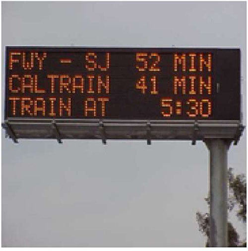
Figure 4. Display of Multimodal Travel Information on VMS [25].
Return to top ↑
Mobility on Demand (MOD)
The Mobility on Demand (MOD) concept represents the vision of USDOT for safe, reliable travel for all users. The MOD program is a multimodal program to study emerging mobility services, public transportation networks and operations, and goods delivery services. MOD is based on the principle that transportation is a commodity where modes have economic values that are distinguishable in terms of cost, journey time, wait time, number of connections, convenience, and other attributes. MOD enables consumers to access mobility, goods, and services on demand by dispatching or using shared mobility, delivery services, and public transportation solutions through an integrated and connected multi-modal network (Figure 5) [11].
Passenger modes facilitated through MOD providers include the following: carsharing, ridesharing (carpooling and vanpooling), Transportation Network Companies (TNCs, also known as ride-sourcing and ride-hailing), shared micromobility (e.g., scooter sharing and bike sharing), microtransit, shuttle services, public transportation, and other emerging transportation strategies.
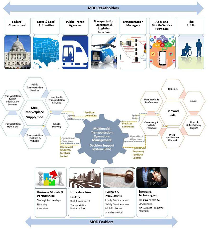
Source: USDOT, August 2017
Figure 5 Mobility on Demand Ecosystem [11].
Return to top ↑
Mobility as a Service (MaaS)
MaaS primarily focuses on passenger mobility aggregation and subscription services [36]. It is a mobility system bringing together public and transit transportation providers, either with a subscription or pay-as-you-go format. Users pay to access the system, and in return have greater access to a wide variety of transportation modes and solutions.
Transportation Network Companies
Transportation network companies are services that offer on-demand rides by connecting drivers using their personal vehicles with passengers hailing a ride, typically via a smartphone application. TNC services have grown rapidly since the launch of Uber in 2010 and Lyft in 2012 (Figure 6). Different business models of TNC service include partnerships with transit agencies for first/last mile service or service provided for a capped price within a geofenced area.
Data from five metropolitan areas show that most TNC trips in the study regions are short and concentrated in downtown core neighborhoods [35]. The heaviest TNC use is during evening hours and weekends. There is no clear relationship between the level of peak-hour TNC use and long term changes in the study regions’ public transit usage. The main reasons for replacing transit trips with TNC are travel time and wait time.
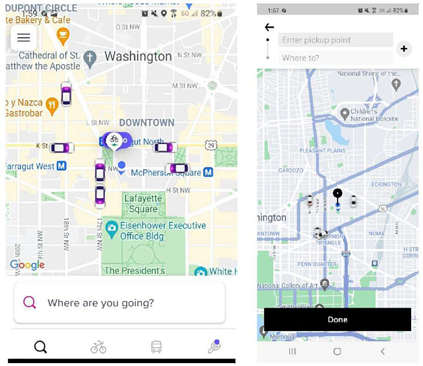
Figure 6. Smartphone Applications for TNCs.
Carsharing
Carsharing refers to a form of short-term vehicle access typically billed hourly or by the minute. Carsharing is designed for users who need occasional access to a private vehicle. Carsharing services are available to most metropolitan areas worldwide and provided by private companies (e.g., Zipcar, City CarShare). Applications for mobile devices allow users to locate, and access vehicles to reserve. Customers are also able to see the fuel or battery available for gasoline-powered vehicles or battery charge for electric cars, and they can reserve parking for their destination. In 2018, there were 1.5 million members and over 15,000 vehicles available in the United States [35].
In several locations, carsharing vehicles are used on one-way trips (pick-up a vehicle at one location and drop it off at another), that provide first-mile and last-mile access to transit stops. Other reported carsharing benefits include reductions in auto ownership, VMT, fuel consumption, and emissions. Impacts on transit ridership are mixed, with no changes in active transportation (walking and bicycles) usage.
Bike Sharing
There are more than 30 million bike sharing users in the United States [33]. Bike sharing systems increased mobility, increased flexibility, cost savings from modal shifts, low implementation and operational costs, increased health benefits, and greater environmental awareness.
Bike sharing systems are integrated into existing transportation systems to facilitate multimodal mobility. Bicycle stations are often located in public transit hubs and payment systems can be integrated. Many cities implement “complete streets” designs to improve the safety of bicycle riders designating protected bicycle lanes and transit priority at traffic signals.
Alternative Transit Services
Alternative transit services, which include paratransit, employer shuttles, and microtransit, have the potential to supplement existing bus and rail fixed routes. Microtransit services can be fixed-route with fixed-schedule or flexible-route with on-demand scheduling. These services can incorporate flexible routing, flexible scheduling, or both.
Transit agencies collaborate with TNCs to designate curb space or other specific locations for TNC pick-up/ drop-offs to minimize conflict near transit stops or stations and pursue cost savings through public-private partnerships on late-night, call-and-ride, and paratransit services. Transit agencies in midsized urban areas may want to explore first-mile and last-mile partnership opportunities with TNCs to help attract new riders and increase the utility of public transit in lower-density areas.
Return to top ↑
Parking Information
Parking information traditionally consisted of maps of available parking facilities. Currently, most cities across the United States provide pre-trip parking information over the Internet. Web pages provide maps with the location of the parking facilities and other information, such as a facility’s address, capacity, hours of operation, costs, and forms of payment accepted.
Parking lot-specific systems employ dynamic message signs to provide both hours of operation and space availability information. More sophisticated parking information systems have signs on every floor of a garage, at the start of every aisle, and sometimes in front of every individual parking space [9,39]. The basic technologies employed consist of entry/exit counters and space occupancy sensors. Inductive loops, ultrasonic sensors, and video are typical surveillance technologies. Communication is provided through fiber optic lines or radio frequency identification (RFID) on most parking facilities.
Currently, a number of private service providers (e.g., Streetline, ParkMe, Park Assist ParkingCarma, ParkMobile, SpotHero) have developed applications through the web or on mobile devices to display parking availability in real-time, make online reservations, and make electronic payments. These providers obtain real-time information through parking occupancy sensors, or in the case, such data is not available, by predicting the parking facility’s occupancy from past information.
An example of an advanced parking information and management system is SFpark implemented by the city of San Francisco, California [37]. Parking availability is displayed on the web and on smartphones through custom mobile applications (Figure 7). Parking occupancy is obtained from wireless sensors at each parking location. Pricing on both street parking and garages varies by time of day and day of the week to maximize utilization. Pricing is determined to maintain parking occupancy up to 85 percent.
The ParkDC system implemented in Washington, DC uses a unique approach to determine the occupancy and set parking pricing. It uses spatial and temporal sampling, partial sensor coverage, payment data, fixed and portable video cameras, computer vision algorithms, and other data. The blended data approach informs several real-time parking apps [23].
The availability of real-time parking at transit stations and online reservation systems permits the linking of auto and transit trips that allow travelers to change travel modes on-route [29]. Variable message signs display information to motorists on roadway traffic conditions (e.g., accidents and delays), availability of parking in park-and-ride lots, and departure time of the next train. Drivers may decide to park and ride transit if the expected travel time to their destination is faster than the estimated driving time. A pilot test (smart parking) sponsored by the California Department of Transportation (Caltrans) in collaboration with the Bay Area Rapid Transit (BART) District demonstrated the feasibility of the system [34].
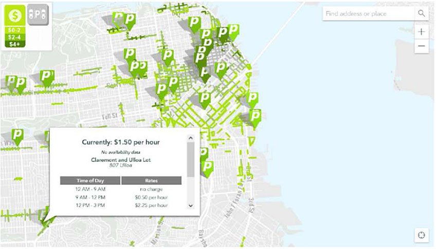
Figure 7. San Francisco Real-Time Parking Information [37].
Return to top ↑
Driver Assistance Systems
This section focuses on technologies and systems primarily designed to improve driver safety. ITS technologies for traveler comfort and convenience are described in the next section.
ITS technologies for improving driver safety include the following:
- Intersection collision warning systems (CWS) detect and warn drivers of approaching traffic and potential right-of-way violations at intersections.
- Pedestrian automatic emergency braking systems use information from forward sensors to detect a pedestrian in the vehicle’s path. The system will provide automatic braking if the driver has not acted to avoid the collision.
- Obstacle detection systems use vehicle-mounted sensors to detect obstructions (e.g., other vehicles, road debris, or animals) in a vehicle’s path or projected path and alert the driver.
- Blind-spot detection/information systems (BLIS) alert the drivers to the presence of other vehicles in their blind spot.
- Lane change warning systems alert drivers of the presence of vehicles or other obstructions in adjacent lanes when the driver prepares to change lanes.
- Rollover warning systems notify drivers when they are traveling too fast for an approaching curve, given their vehicle’s operating characteristics.
- Road departure warning systems warn drivers that their vehicle is about to leave the roadway, whether they are approaching a curve too fast, or begin to unintentionally drift off the travel lane.
- Forward collision warning (FCW) systems, also known as rear-end collision avoidance systems, warn drivers that they are in a conflict situation with a lead vehicle. These conflicts can arise when the lead vehicle is stopped, slowing, or traveling at a constant speed.
- Rear-impact warning systems warn the lead vehicle driver that they are in conflict with a following vehicle. The warning can be presented by the lead vehicle or transmitted from the following vehicle to an in-vehicle warning system in the leading vehicle.
- In-vehicle vision enhancement improves visibility for driving conditions involving reduced sight distance due to night driving, inadequate lighting, fog, drifting snow, or other inclement weather conditions.
- Drowsy driver warning systems alert the driver that he or she is fatigued, which may lead to lane departure or road departure.
- Wrong-way driving warnings alert the drivers not to enter the wrong way travel direction.
- Adaptive cruise control automatically adjusts the vehicle’s speed to keep a preset distance to the vehicle in front of it.
Most of the above-described systems have been developed or tested under the USDOT Integrated Vehicle-Based Safety System (IVBSS) initiative, which focuses on improving safety for light vehicles and heavy trucks. IVBSS ended in 2011 and the relevant research continues under the Automation ITS Research Area and the Emerging and Enabling Technologies ITS Research Area. For more information, see the Tech Overview section of NHTSA’s Driver Assistance Technologies resource page and the resource page of ITS JPO on Connected Vehicle applications.
The video in the following link shows an advanced driver assistance system developed at the California PATH, University of California Berkeley [24,28,38]. This system integrates GPS, digital map, on-board sensors, and wireless communication to perform a variety of driver assistance functions, such as in-vehicle signage, speed warning, curve over-speed warning, lane-departure warning, and wrong-way warning. The system provides access to real-time roadway information and map update via vehicle-infrastructure wireless communication, robust high-accuracy vehicle positioning through sensor fusion of GPS, DR sensors, digital map data, and multiple warning means, such as audio, visual, and speech warnings, through selected driver machine interfaces (e.g., dashboard device or Bluetooth enabled cell phone). https://www.youtube.com/watch?v=5vuKvW_5QVM
Return to top ↑
Traveler Comfort and Convenience
This section describes ITS technologies for improving the travel experience. For drivers, such technologies include navigation systems, navigation systems with prediction and adoption incentives [22], electronic payment, and parking assist. For transit riders, technologies include integrated payment technologies.
In-vehicle navigation and route guidance systems with GPS technology provide turn-by-turn directions to drivers to reach their destinations thereby reducing unnecessary distance traveled. Typically, these systems include additional information for local businesses (electronic yellow pages) and parking availability. These systems may be after market or provided by the auto manufacturers for a monthly subscription service (e.g., GM OnStar® system).
Electronic toll collection (ETC) facilitates payment at toll facilities. Drivers pay the posted tolls through a supplied transponder in the vehicle without stopping at the toll plaza. ETC Data systems operate as either an integrated multi-state system such as the E-Z Pass system, or single-state or single toll authority systems such as the California FasTrak system and Florida’s SunPass system.
ETC improves the toll lane capacities by up to five times under open road tolling (ORT) compared to manual toll collection [16]. Open-road tolling does not utilize tollbooths and drivers transverse toll plazas at highway speeds. Open-road ETC systems also can use license-plate recognition technology to bill drivers who do not have transponders. Because drivers do not have to stop, ETC can reduce fuel consumption and emissions at tollbooths by minimizing delays, queuing, and idling time. ETC transponders may also be used to pay for parking at airports and other facilities.
ORT facilities have significant safety benefits. A recent study at the Garden Expressway in New Jersey shows that crashes at locations where ORT systems were deployed are decreased by about 24 percent after the deployment of these systems [46]. Data from Florida’s Turnpike Enterprise, Orlando-Orange County Expressway Authority show that conversion to ORT reduces tolling accidents by more than 60 percent [15].
ETC technology is essential for the implementation of congestion pricing schemes that are increasingly been implemented on existing highway facilities (e.g., express lanes, and conversion of high occupancy vehicle (HOV) to high occupancy toll (HOT) lanes). Drivers must have ETC transponders to use these facilities. The ETC technology is generally different than the traditional toll collection since pricing varies by prevailing traffic conditions in order to maintain a predetermined level of service and passenger occupancy levels.
Transit fare payment systems can provide increased convenience to customers and generate significant cost savings to transit agencies by reducing the costs involved in cash-handling transactions. Transit users may use magnetic stripe cards (read-only or read-write), smart cards with varying levels of memory and computing power, credit cards, or mobile phones to pay for transportation services. Fare transaction machines can read and write to multiple types of media and fare products, and regional processing centers can consolidate financial information and streamline fare transaction management for multiple transit agencies. Many fare card systems provide additional benefits to travelers such as providing records on trips taken and fares purchased that can be used to support tax rebates or employer incentives to transit use.
As of January 2018, 34 locations around the country had deployed automated fare collection (AFC) in their transit systems [44]. Eighteen of these systems are implementing Mobility Payment Integration (MPI) to encompass new forms of personal mobility. MPI systems incorporate shared payment media across the participating transit agencies and mobility providers (e.g., bike share, TNCs, and microtransit).
Return to top ↑
Personal Rapid Transit
Personal rapid transit (PRT) systems consist of small, driverless vehicles efficiently navigating a network of interconnecting tracks. Key operational characteristics include off-line stations, on-demand operation, point-to-point travel and taxi-style comfort and convenience. PRT systems can be used as feeders into existing transit systems or as a standalone system providing direct service within city centers and at airports, attractions, campuses, parks, and hospitals [30].
The concept of PRT was originally developed in the late 1950s as an alternative public transport mode in areas where the population densities were too low to justify the construction of a conventional fixed-route system. The automated guidance allows short vehicle headways in the order of a few seconds, which increases the route capacity, allowing the vehicles to become much smaller while still carrying the same passenger load in a given time. Smaller vehicles in turn would require simpler fixed guideways and smaller stations that result in lower capital costs.
Numerous PRT systems were designed in the late 1960s and early 1970s; most of them consisted of small four to six passenger vehicles, and most evolved to larger designs over time. However, none of these systems has been implemented because of high capital costs and other factors. The only production PRT system installed is the Morgantown PRT system in Morgantown, West Virginia, and connects the three Morgantown campuses of West Virginia University and the downtown area, for a total track length of 8.65 miles and five stations. The system includes 73 vehicles, approximately 15 feet long with a capacity of 20 passengers.
A review of the operational characteristics of existing and proposed PRT technologies [8,31] indicates that vehicle capacity ranged from one to 15 people, with four being the average. Line speed ranged from 13 to 150 mpg, with an average speed of 30 mph. Only three systems claimed line speeds of 65 mph or higher, with the rest of the systems operating in a more conservative 13 to 38 mph range. Minimum headways ranged from 0.5 to 4 seconds. Short headways provide for higher throughput to accommodate high passenger demands. However, the minimum chosen headway must satisfy the requirement that the following vehicle must be able to stop without affecting an immediately upstream vehicle that comes to a sudden stop (“brick-wall” headway). The minimum headway varies with speed and system capabilities with typical values of 1.5 to 2 seconds.
ULTra (Urban Light Transit) is a PRT system developed by ULTra PRT and is operational at London’s Heathrow airport since May 2011 (Figure 8.) [18]. It runs between the airport’s Terminal 5 and its business parking lot, with 2.4 miles of track and 21 vehicles. Operational statistics indicate above 99 percent system reliability, and an average passenger wait time over the one-year period of 10 seconds. The 2getthere system in the city of Masdar in Abu Dhabi consists of two stations over a 1.1 mile of track with 10 vehicles, each carrying up to six passengers [18]. The system is operational for over 15 months with 3,000 trips per day. The PRT system in the city of Suncheon in South Korea, operational since 2013, consists of 3 miles of track and two stations and 40 vehicles connecting the downtown Suncheon to an exhibition center [18].
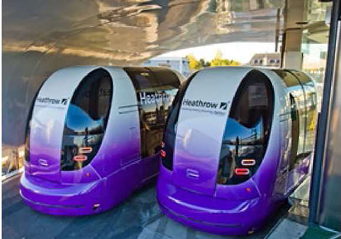
Figure 8. The ULTra PRT System.
Return to top ↑
Urban Aerial Mobility
Advanced aerial mobility or unmanned aerial vehicles (UAV) are a newly-emerging industry that aims to develop and operate new aircraft potentially capable of safe, reliable, and low-noise vertical flight [7]. These innovations and technologies change the way we move cargo and people, affecting industries across the economy.
The future seems bright for the UAV industry, helped in huge part by a thriving commercial market. The commercial UAV U.S. market is expected to grow to about $13.6B by 2025. Safe and cost-efficient passenger carrying UAVs for the public appear to be further into the future. In the context of a transportation system, UAVs can be categorized by application, as follows:
- Package delivery. In November 2020, the FAA proposed airworthiness criteria for type certification of delivery drones with an intent to initialize commercial operations. There are 10 companies that received this type of certification for their aircraft. A number of companies are developing fleet management solutions [5].
- Mapping and surveying. Use of UAVs to capture aerial data with downward-facing sensors, such as RGB or multispectral cameras, and LiDAR (light detecting and ranging) payloads. During a drone survey with an RGB camera, the ground is photographed several times from different angles, and each image is tagged with coordinates. UAVs used for this purpose must have a long battery time and be equipped with high-precision global navigation satellite systems (GNSS) and interchangeable sensors, such as LiDAR, 4K camera, thermal imaging, and multispectral imaging.
- Infrastructure inspections. UAVs are particularly useful for inspections that are dangerous for human surveyors, such as bridges, tunnels, or disaster areas. Generally, it is required that UAVs operate in a GNSS-less environment.
- Surveillance. Aerial surveillance of large areas, including road patrol, is possible with low-cost UAVs. Object detection and tracking capability drive the expansion of this application.
- Passenger transport. Also known as flying taxis, passenger UAVs are being developed by air and automobile manufacturers.
Return to top ↑
Vehicles, Internet, Communications, and the Future
The Internet of Things (IoT) describes physical objects equipped with sensors, processing software, communication ability, and other technologies that connect and exchange data with other devices and systems over the Internet or other communications networks. The IoT can assist in the integration of communications, control, and information processing and dissemination across various transportation systems. Application of the IoT extends to all components of transportation systems (e.g., vehicle, infrastructure, driver, other road users - bicyclist or pedestrian). Dynamic interaction between these components of a transportation system enables inter and intra-vehicular communication, intelligent traffic control, intelligent parking, electronic toll collection systems, logistics and fleet management, vehicle control, safety, and road assistance.
Emerging vehicle technologies include cooperative vehicle infrastructure systems, and automated driving to improve safety, mobility and to reduce excess fuel consumption and emissions. Cooperative vehicle infrastructure systems or connected vehicles (CV) consist of vehicle-to-vehicle (V2V), vehicle to infrastructure (V2I), and infrastructure to vehicle (I2V) communications [42]. Module 13 of the e-Primer discusses in detail the status and potential applications of connected vehicles.
Connected vehicle (CV) technology is important for ensuring the efficient and safe operations of roadway vehicles, and it is especially important to integrate with automated vehicle technology. CV technology allows vehicles to communicate with each other and the world around them to ensure greater safety and efficiency benefits. CV technology can enable transportation agencies to access vehicle data related to speed, location, and trajectory, which could allow for better management of traffic flow in real time.
V2I communications for safety is the wireless exchange of critical safety and operational data between vehicles and highway infrastructure, intended primarily to avoid or mitigate motor vehicle crashes but also to enable a wide range of other safety, mobility, and environmental applications. One example is the ability for existing traffic signal systems to communicate the signal phase and timing (SpaT) information to the vehicle in support of delivering active safety advisories and warnings to drivers, as illustrated in Figure 9 below. V2I communications could potentially address an additional 12 percent of crash types not addressed under V2V communications.
The availability of connected vehicle data will provide the opportunity for a wide range of dynamic, multimodal applications to manage the transportation system for optimum performance. Examples include adaptive signal control, accurate and timely traveler information, and other strategies to mitigate incident impacts and improve travel time reliability for transit and freight movements. The deployment of such strategies depends on the penetration rate of CV equipped vehicles. Three connected vehicle pilots have been deployed in Manhattan, New York City; Tampa, Florida; and Wyoming [21].
V2I connected vehicle data may also significantly reduce the environmental impacts of each trip. Informed travelers may decide to take environmentally friendly routes. The availability of vehicle data (e.g., location and speed) and the SpaT information from the signal system are used to create driver speed advisories to minimize fuel consumption and emissions. An experimental system developed by BMW as part of USDOT exploratory advanced research project provides in-vehicle real-time speed advisory based on the SpaT information [2]. The driver interface displays the recommended speed for minimum fuel and the signal settings (Figure 10).
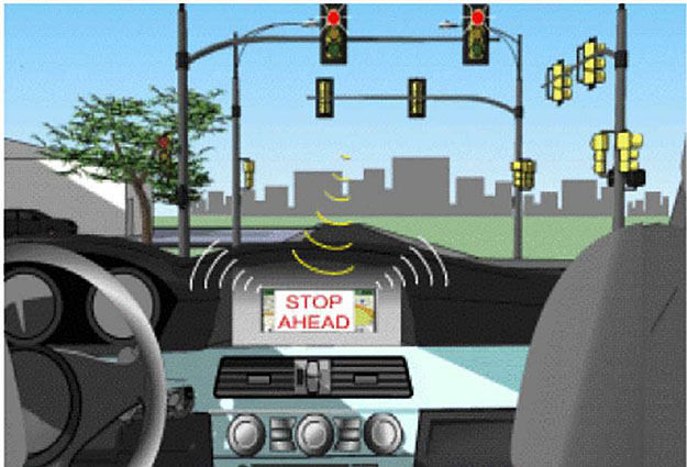
Figure 9. V2I Communication: The SPaT Message. [5]
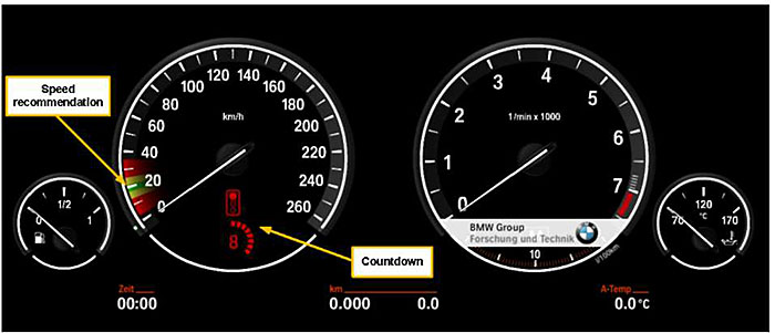
Figure 10. BMW In-Vehicle Driver Speed Advisory.
Automated Vehicles
As of 2021, 30 companies around the world are developing automated vehicles (AV) technology including most major auto manufacturers and many technology companies. The emphasis is on developing “level 4” automated vehicles, in which there is no need for human drivers to intervene.
Currently, Waymo [19] is the only automated private passenger vehicle in operation that has actually driven passengers without the constant supervision of a safety test driver. Waymo employs several sensing systems, including a multitude of LiDAR, radar, cameras, inertial, and audio units that provide an expansive understanding of the driving environment and the vehicle’s precise location at any given point in time. Waymo field testing data represent more than 6.1 million miles of automated driving in the Phoenix, Arizona metropolitan area, including operations with and without a human operator in the last 2 years. There were 47 disengagements (events requiring that driver takes manual control of the vehicle) that occurred over this time, consisting of 18 actual and 29 simulated events, none of which would be expected to result in severe or life-threatening injuries [40].
Another example of automated vehicles in use is Nuro [20], which uses vehicles about the size of a mini-car to deliver local packages. There is no space provided for an onboard driver. These custom autonomous delivery vehicles are designed to operate at low speeds in neighborhoods.
Return to top ↑
Summary
This module describes the capabilities, features, and limitations of ITS technologies for multimodal transportation that enhance safety and mobility, and reduce excess fuel consumption and emissions.
Real-time travel information assists travelers prior to their trip or while en route. Pre-trip information includes traffic, transit, and multimodal options; weather, incidents, and work zones for users to make informed decisions for trip departure; and route choice and mode of travel. En route information allows users to make informed decisions regarding alternate routes, mode or travel options, and travel times. Information is posted on Internet websites, television, radio, vehicle devices, mobile phone applications, and roadside message signs. Data sources for traveler information systems include fixed detectors, event information, video recording, and mobile sources. Mobile sources include probe data from transponders, Bluetooth readers, cellular phones equipped with global positioning systems, and personal and commercial in-vehicle navigation systems. Benefits include improved on-time reliability, better trip planning, and reduced early and late arrivals.
Mobility on demand is a framework to enable consumers to access mobility, goods, and services on demand by using public transportation facilities, shared mobility, and delivery services through an integrated and connected multi-modal network. Passenger modes facilitated through MOD providers include carsharing, ridesharing (carpooling and vanpooling), transportation network companies, shared micromobility (e.g., scooter sharing and bike sharing), microtransit, shuttle services, and public transportation. Mobility as a service connects public and private transportation providers, either with a subscription or pay-as-you-go format.
Parking information is provided by public agencies and private companies on websites or on mobile devices to display location maps of parking lots, make online reservations, and make electronic payments. Real-time information on parking availability is provided by sensors and fusion from multiple data sources. Pricing is determined on street parking and in garages by time of day to maximize utilization, typically maintaining parking occupancy up to 85 percent.
Several ITS technologies focus on driver safety. Blind-spot detection/information systems alert the drivers for the presence of other vehicles in their blind spot. Lane change warning systems alert drivers of the presence of vehicles or other obstructions in adjacent lanes. Road departure and rollover warning systems warn drivers when they are traveling too fast for an approaching curve. Forward collision warning systems warn drivers that they are in a conflict situation with a lead vehicle. In-vehicle vision enhancement improves visibility for driving conditions. Drowsy driver warning systems alert drivers that are fatigued. Intersection collision warning systems warn drivers of approaching traffic and potential right-of-way violations at intersections. Wrong-way driving alert notifies the driver not to enter the wrong way travel direction. Pedestrian emergency braking systems detect a pedestrian in the vehicle’s path.
ITS technologies to improve the travel experience include navigation systems, parking assistance, and electronic payment. Electronic Toll Collection facilitates payment at toll facilities and parking garages at airports and other facilities. Open-road tolling does not utilize tollbooths and allows drivers to traverse toll plazas at highway speeds. Automated payment systems collect fares for multiple transit systems in regional areas. Mobility payment systems encompass fare collection for participating transit agencies and mobility providers.
Advanced aerial mobility or unmanned aerial vehicle is a newly emerging industry that aims to develop and operate new aircraft potentially capable of safe, reliable, and low-noise vertical flight. The use of the UAV for delivering consumer goods is increasing, helped in part by a thriving commercial market. UAVs that carry public passengers appear to be further into the future and subject to regulatory, environment, infrastructure, and environmental constraints.
Emerging vehicle technologies focus on cooperative vehicle infrastructure systems, vehicle-to-vehicle and vehicle-to-infrastructure communications, and automated vehicles. V2V data provides the opportunity to implement speed harmonization and queue warning systems. Benefits include higher freeway capacity, lower travel times, improved travel time reliability, and reduction in the frequency and severity of crashes. V2I provides vehicle data (e.g., location and speed) and signal phase and timing (SPaT) information to implement adaptive signal control and create driver speed advisories to minimize fuel consumption and emissions. Automated vehicle technology is actively pursued by most major auto manufacturers and many technology companies. The emphasis is on developing “level 4” automated vehicles, in which there is no need for human drivers to intervene in the driving task.
Return to top ↑
References
1. Amin-Naseri M., P. Chakraborty, A. Sharma, “Evaluating the Reliability, Coverage and Added Value of Crowdsourced Traffic Incident Reports from Waze,” paper presented at the 99th Transportation Research Board Annual Meeting. Washington DC. January 2018.
2. BMW. “Advanced Traffic Signal Control.” FHWA Exploratory Advanced Research Project Final Report. July 2012.
3. Bruzon V., P. Masters. “Evaluation of the Effectiveness of the COMPASS System.” 4th World Congress on Intelligent Transport Systems. October 1997. Berlin, Germany, Paper No. 1070.
4. Cabannes et al. “The impact of GPS-enabled Shortest Path Routing on Mobility: A Game Theoretic Approach,” paper presented at the 99th Transportation Research Board Annual Meeting. Washington DC. January 2018.
5. California PATH. “Investigating the Potential Benefits of Broadcasted Signal Phase and Timing (SPaT) Data under IntelliDrive.” Final Report, IntelliDrive Pooled Fund Study. University of Virginia. May 2011.
6. California PATH. “Emerging Technologies for Transportation,” research report, prepared for the California Department of Transportation, University of California, Berkeley. 2021.
7. Cohen A.P., S. Shaheen, E.M. Farrar. “Urban Air Mobility: History, Ecosystem, Market Potential, and Challenges.” IEEE Transactions on Intelligent Transportation Systems. Volume 22 (9). September 2021.
8. Cottrell W.D. and Mikosza O. “New-Generation Personal Rapid Transit Technologies: Overview and Comparison.” Transportation Research Record Journal of the Transportation Research Board, No. 2042. Washington DC. pp. 101-108. 2008.
9. Federal Highway Administration. “Advanced Parking Management Systems: A Cross-Cutting Study.” Report FHWA-JPO-07-011. January 2007.
10. Federal Highway Administration. “Integrated Corridor Management Analysis, Modeling and Simulation (AMS) Methodology.” Report FHWA-JPO-08-034-EDL 14414. Washington DC. March 2008.
11. Federal Highway Administration. “Mobility on Demand: Operational Concept Report.,” Report FHWA-JPO-18-611. Washington DC. September 2017.
12. Federal Highway Administration. , “Intelligent Transportation Systems Benefits, Costs and Lessons Learned 2018 Update Report.” Report FHWA-JPO-18-641. Washington DC. March 2018.
13. Federal Highway Administration. “Considerations of Current and Emerging Transportation Management Center Data.” Report FHWA-HOP-18-084. Washington DC. July 2019.
14. Federal Transit Administration. “Traveler Information Systems and Wayfinding Technologies in Transit Systems.” Report FTA-MA-26-7998-2011.1. May 2011.
15. Gordin E., J. Crodsinki, C.D. Santos. “Safety Benefits from Deployment of Open Road Tolling for Main Lines Toll Plazas in Florida.” Transportation Research Record, Journal of the Transportation Research Board. January 2011.
16. Institute of Transportation Engineers. “ITS Primer Volume #8: Electronic Toll Collection and Pricing.” 2013. eprimer/documents/module8.pdf.
17. Information on SILVER Alert: https://silveralertbill.com/ (American Silver Alert Coalition). Website no longer available.
18. Information on the Masdar, ULTra, Suncheon PRT systems: https://www.2getthere.eu/ https://www.ultraglobalprt.com/ http://www.advancedtransit.org/advanced-transit/applications/suncheon/
19. Information on Waymo autonomous vehicles: https://waymo.com/
20. Information on NURO autonomous vehicles: https://www.nuro.ai/
21. ITS JPO Connected vehicle initiative: https://its.dot.gov/cv basics/index.htm
22. Metropia Smart Navigation App https://www.metropia.com
23. Kittelson Associates. “ParkDC: Penn Quarter Chinatown Parking Pricing Pilot.” Final Report. Washington DC. January 2019.
24. Misener, J. A., et al.“ Onboard Monitoring and Reporting for Commercial Motor Vehicle Safety.” Report FMCSA-RRT-07-030. Federal Motor Carrier Safety Administration. Washington DC. 2007.
25. Mortazavi, A. et al. “Evaluation of Displaying Transit Information on Changeable Message Signs.” CCIT Research Report UCB-ITS-CWP-2009-2. University of California Berkeley. September 2009.
26. National Cooperative Highway Research Program. Synthesis 399. “Real Time Traveler Information Systems.” Transportation Research Board. Washington DC. 2009.
27. National Cooperative Highway Research Program. Web Report 192. “Deployment Use and Effect of Real Time Traveler Information Systems.” Transportation Research Board, Washington DC. 2013.
28. Nowakowski, C., et al. Cooperative Adaptive Cruise Control: Testing Drivers’ Choices of Following Distances. California PATH Research Report for FHWA Exploratory Advanced Research Program Cooperative Agreement DTFH61-07-H-00038. January 2011.
29. Organization for Economic Co-operation and Development (OECD), “The Shared Used City: Managing the Curb.” Report, 2018. https://www.itf-oecd.org/sites/default/files/docs/shared-use-city-managing-curb_5.pdf.
30. Raney, S., J. Paxson, and D. Maymudes. “Design of Personal Rapid Transit Circulator for Major Activity Center: Hacienda Business Park, Pleasanton, California.” Transportation Research Record Journal of the Transportation Research Board, No. 2006, Washington DC. 2007. pp. 104-113, 2007.
31. Schneider, J.B. Overview of PRT systems and links to PRT websites. http://faculty.washington.edu/jbs/itrans/prtquick.htm.
32. Shaheen, S., E. Magsig, A, Cohen, E. Martin. “Mobility on Demand (MOD) Sandbox Demonstration Tri-Met OpenTrip Planner (OTP) Shared-Use Mobility.” Evaluation Report. FTA Report No. 0170.July 2020.
33. Shaheen, S., H. Totte, A. Stocker. “Future of Mobility Innovative Mobility White Paper.” Transportation Sustainability Research Center, University of California, Berkeley. 2018.
34. Shaheen, S., C. Rodier. “Smart Parking Management Field Test: A BART District Parking Demonstration.” Final Report UCD-ITS-RR-08-32. University of California, Davis. June 2008.
35. Shaheen, S., A. Cohen. “Innovative Mobility: Carsharing Outlook Market Overview, Analysis, and Trends.” Transportation Sustainability Research Center, University of California, Berkeley. Winter 2020.
36. Shaheen, S., A. Cohen. “Similarities and Differences Mobility on Demand (MOD) and Mobility as a Service (MaaS).” ITE Journal. June 2020. www.ite.org.
37. SFPark https://www.sfmta.com/demand-responsive-parking-pricing.
38. Tan H-S et al. “Field Demonstration and Tests of Lane Assist/Guidance and Precision Docking Technology.” California PATH Research Report UCB-ITS-PRR-2009-12. January 2009.
39. Trista Lin T., H Rivano, and F Le Mouel. “A Survey of Smart Parking Solutions.” IEEE Transactions on Intelligent Transportation Systems, Vol 18, No.12.December 2017.
40. Webb N., Smith D., et al. “Waymo’s Safety Methodologies and Safety Readiness Determinations.” October 2020. https://Waymo.com/safety/.
41. United States Department of Transportation Research and Innovative Technology Administration. , “Intelligent Transportation Systems Benefits, Costs, Deployment, and Lessons Learned Desk Reference: 2011 Update,” Final Report FHWA-JPO-11-140. September 2011.
42. United States Department of Transportation Research and Innovative Technology Administration., “AASHTO Connected Vehicle Infrastructure Deployment Analysis Final Report.” FHWA-JPO-11-090. Washington DC. June 2011.
43. United States Department of Transportation. Deployment of ITS: A Summary of the 2010 National Survey Results (Final Report). Prepared by Oak Ridge National Laboratory for the USDOT Research and Innovative Technology Administration. August 2011.
44. United States Department of Transportation Volpe National Transportation Systems Center, “Mobility Payment Integration: State of the Practice Scan,” FTA Report No 0143, October 2019.
45. Vasudevan, M., and K. Wunderlich. “Quantifying Serenity Benefits from Use of Advanced Traveler Information Services (ATIS).” prepared by Mitretek Systems for the Federal Highway Administration. October 2004.
46. Yang, H, K. Ozbay and B. Bartin. “Effects of Open Road Tolling on Safety Performance on Freeway Mainline Toll Plazas.” 91st TRB Annual Meeting. Washington DC. January 2012.
Return to top ↑