
About
The Intelligent Transportations Systems Joint Program Office (ITS JPO)
OUR VISION:
Accelerate the use of ITS to transform the way society moves.
OUR MISSION:
Lead collaborative and innovative research, development, and implementation of ITS to improve the safety and mobility of people and goods.
Planning for the Future of ITS
The ITS Joint Program Offices 2020-2025 ITS Strategic Plan
About ITS JPO
Current Research
The U.S. Department of Transportations ITS research focuses on several high-priority areas including Emerging and Enabling Technologies, Data Access and Exchanges, ITS Cybersecurity Research, Automation, ITS4US, and Accelerating ITS Deployment. The ITS Strategic Plan includes in-depth discussion of the ITS Programs strategic goals, these research areas, and four technology transfer programs.
Learn more in the 2020-2025 ITS Strategic Plan.
Research Areas
Intelligent Transportation Systems Deployment
| Connected Vehicle Pilots | ||
|
View NYCDOT pilot |
View THEA pilot |
View WYDOT pilot |
ITS Deployment
- ITS4US
- Vehicle-to-Infrastructure Resources
- Connected Vehicle Pilots
- Connected Vehicle News and Events
- Connected Vehicle Deployer Resources
- Connected Vehicle Deployment Assistance
- Connected Vehicle Applications
- Sample Deployment Concepts
- Connected Vehicle Publications
- National ITS Architecture
- Smart City Challenge
Technology Transfer

|
|
Technology Transfer


Research Archive

Mobility Services for All Americans (MSAA)
3. Linking Technology with Access and Mobility
Technology plays a key role and presents great opportunities for enhancing transportation accessibility and mobility for all Americans. This chapter considers technologies, including transit ITS, assistive technologies, and other technologies that can be used to improve the availability and accessibility of public transportation services for all persons, particularly those who are transportation disadvantaged. These technologies and services can provide the following:
- Improving the availability of information about public transportation services, including fixed route, demand-response, taxi, ridesharing, and related concerns.
- Improving the access, egress, and ease of use of both conventional fixed route transit (including bus and rail services) and over-the-road coaches.
- Improving accessible paratransit services, including demand-response transportation, taxis, and other flexibly routed services.
- Enabling a multimodal approach to provide fully accessible and coordinated transportation services.
As described earlier, the team conducted a thorough literature review to develop inventories of state-of-the-practice and state-of-the-art technologies and methods that are currently available. The review included information and references pertaining to projects – past and present – that employ advanced technologies to improve accessibility and mobility. As described in the previous section, special emphasis has been placed on technologies that enhance system accessibility and enable coordination between and among transit and human service programs/organizations and across a continuum of transportation options, including:
- Recent developments, deployments, and evaluations of technologies, especially transit ITS technologies, for transportation coordination and service quality improvement.
- State-of-the-art transit ITS technologies as well as their respective deployment maturity and potential for advancing transportation quality and operational efficiency.
This section builds on the materials presented in the previous sections to demonstrate how various technologies and human factors may be used to enhance access and mobility for persons who are transportation disadvantaged. This section is divided into five areas:
- 3.1: Description of available technologies.
- 3.2: Applicability of technologies.
- 3.3: State of readiness and level of deployment for each technology.
- 3.4: Examples of current technology deployment.
- 3.5: Issues and barriers associated with technology implementation.
3.1 Description of Available Technologies
This section describes a variety of transit ITS technologies that are currently being used to enhance public transportation services. The second part of this section also describes AT that are designed to provide individuals with additional technology tools to accommodate personal needs related to system use. Although the focus of the description of available technologies discussed in this document is aimed toward the transportation disadvantaged communities, all Americans may benefit from many of these technological applications.
3.1.1 Transit ITS
ITS applies advanced and emerging technologies in information processing, communications, control, and electronics to surface transportation needs. In combination with human factors, ITS technologies help improve transportation mobility, safety, and productivity. ITS technologies applied to transit are called transit ITS technologies (also known as Advanced Public Transportation Systems or APTS). Transit ITS technologies that are most relevant to the MSAA initiative can be grouped into the following categories:
- Fleet management and advanced operations.
- Traveler information.
- Electronic payment systems.
- Safety and security.
Transit ITS technologies that help improve the coordination of human services transportation are discussed below. Most of the technologies are modular. That is, they can be used individually or in combination. They can stand alone, but their functionality and benefits increase when they are combined with other technologies. When working together, certain technologies fill a fundamental role: they are the foundation for a larger system. The functionality and benefits of these foundational technologies "increase when they are combined with other technologies. The other technologies in the system rely on these foundational technologies for data input. This key relationship (i.e., technologies working together) is what the FTA and the FHWA hope to expand on as they work toward the ultimate goal of the MSAA initiative.
The descriptions of these technologies are drawn from a variety of industry sources, including TCRP Synthesis 37 report as well as materials developed by Mitretek and posted on the UWR web site.
Fleet Management and Advanced Operations
The main goal of these technologies is to "manage customers, funding, and human services information and transportation operations. Transit ITS technologies can include:
- Global Positioning Systems (GPS). Global Positioning System receivers located on-board vehicles collect signals from U.S. Government-operated GPS satellites, which they use to calculate the current latitude and longitude of the vehicle. A GPS receiver can operate anywhere with an open view of most of the sky and can provide location accuracy within about 15 meters 95 percent of the time (under the current U.S. Government policy of not limiting civilian applications to the degraded accuracy Selective Availability signal). Many modern GPS receivers also take advantage of the recently (2003) commissioned U.S. government operated Wide Area Augmentation Service (WAAS), which broadcasts additional signals from geosynchronous satellites to allow enhanced accuracy within about 3 meters 95 percent of the time. GPS receivers in vehicles are integral to an automatic vehicle location system.
- Automatic Vehicle Location (AVL). These devices track transit vehicle location in real-time. Transportation providers can use the location information provided by AVL to update passengers continually on vehicle locations. AVLs can be linked to electronic signs to provide accurate arrival time estimates. This historical information, which is stored, can be used to review route and schedule performance, allowing for further optimization.
- Wireless Communications. Wireless communications allows transit vehicles to communicate with a transit operations center via a wireless medium in either voice or data format. The communication can be as simple as a cell phone or radio system. In some cases, a mobile data terminal (MDT) may be used.
Mobile Data Terminals. An MDT "is an integrated transit vehicle computer and data radio communications device," and can send pre-recorded messages that the driver can send. These technologies are used to transfer information on vehicle location and passengers between the driver and operations center. AVL-equipped revenue service vehicles can use this real-time location data by integrating the GPS receiver with an on-board MDT to enable various on-board functions such as (1) detecting time point crossings to calculate current schedule and route adherence status, (2) marking various types of data collected on-board with the current location, (3) triggering a next stop announcement at a pre-determined location upstream from the stop, (4) displaying the location of the vehicle on a map for the driver, and (5) automatically updating the vehicle destination sign route and trip change locations. Figure 3-1 shows a mobile data terminal in use at the Ottumwa Transit Authority.
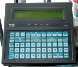
Figure 3-1. Mobile Data Terminal
Photo courtesy of TranSystems. All rights reserved.
- Geographic Information System (GIS). "GIS are special-purpose digital databases in which a common spatial coordinate system is the primary means of reference. GIS contain subsystems for: 1) data input 2) data storage, retrieval, and representation; 3) data management, transformation, and analysis; and 4) data reporting and product generation. A geographical database can store a wide variety of information related to clients, provider employees, routes, and training. GIS is more of a process rather than a thing: GIS supports data collection, analysis, and decision making and is far more than a software or hardware product. Its strength lies in its use as a planning tool: for example, agencies can use these databases to "identify relationships between clients and human services, and can help them identify trip patterns and routes.
- Navigation Systems. Additionally, MDTs can use their AVL capability to incorporate navigation support. This involves providing GIS maps on the MDT and continuously showing the current vehicle location. Paratransit vehicles also can display the location of the next pick-up or drop-off destination, which can be particularly helpful for new drivers or while traveling in unfamiliar service areas. Fixed route vehicles could display the current route (i.e., made available for less experienced drivers to reduce the risk of going off-route).
Using a navigable GIS database for the MDT map display creates the additional option of providing routing information from the current vehicle location to the next destination. A navigable on-board GIS map database would include additional data needed to suggest routings (e.g., one-way streets, turn restrictions, speed limits). As a consequence, a navigable map needs to be updated more frequently to capture ongoing changes in these traffic conditions. One issue is that no matter how often the map is updated, there is a chance of it not being entirely up to date.
- Computer-Aided Dispatch (CAD). CAD software provides a tool to help fixed route and paratransit radio dispatchers manage communications traffic with vehicles. Typical minimum functionality includes (1) listing pending "request to talk" (RTT) voice calls from drivers, (2) allowing dispatch to place voice radio calls to individual vehicles or groups of vehicles, and (3) tracking the status of responses to current operational issues triggered by voice radio calls. Modern transit CAD systems are typically coupled with AVL and mobile data capabilities. The AVL map display is often provided on a separate monitor adjacent to the CAD display. These two displays can also be made available on one monitor by toggling between the two displays. Paratransit CAD software can be an integral component of the paratransit scheduling software. For paratransit operations, CAD software coupled with on-board MDTs and mobile data communications can allow the following functionality:
- Based on real-time location data, same day trips can be scheduled in a more cost effective manner.
- Manifest updates from added or canceled trips can be sent to the vehicles.
- As the vehicle approaches a pick-up location, an interactive voice response (IVR) system can be triggered to notify the customer by telephone automatically (to increase the chance that the passenger will be ready to depart when the vehicle arrives).
- The specific times and locations at which each pick-up and drop-off were completed can be sent to dispatch and automatically logged.
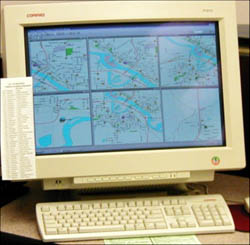
Figure 3-2. Computer-Aided Dispatch
Photo courtesy of TranSystems. All rights reserved.
- Scheduling, Routing, and Dispatching software. These tools benefit the user by increasing the efficiency of the provider's routing and scheduling processes. These tools can optimize scheduling and automate the scheduling process while accommodating many of the special assistance needs that can be encountered when serving transportation disadvantaged clients, such as advanced trip reservations, standing orders, or real-time demand-response service requests. Like GIS databases, one of the strengths of these technologies is their ability to link to other client information databases for eligibility confirmation, billing, and reporting purposes. This technology is especially useful in demand-response applications.
- Customer Management and Eligibility. These solutions are typically databases that track customer account details and eligibility information. These types of databases can act as foundational technologies by sharing information (seamlessly) with other ITS technologies, especially those related to computer-assisted or automated scheduling, billing, and reporting. These solutions are particularly useful in demand-response applications.
- Cost Sharing, Billing, and Reporting. These technologies can help agencies and providers overcome funding barriers by helping them to calculate shared costs while automating and simplifying billing and reporting functions. These technologies are examples of ITS that depend on foundational technologies for data – they are frequently linked to scheduling/routing software, AVL systems, and electronic payment systems. These solutions also are particularly useful in demand-response applications.
- Transfer Connection Protection (TCP). This system works to coordinate and ensure passenger transfers. Like cost sharing systems, it is an example of a technology which depends on other foundational technologies for data. Specifically, it consists of a computer algorithm which relies on AVL data to generate transfer locations and project arrival times of connecting vehicles. In some cases, it then uses wireless communications or MDTs to relay the connection information to the vehicle drivers.
Text messaging capability can be used to support TCP. To accommodate passenger transfers, the driver of an incoming vehicle can register which routes passengers need to connect with. If the incoming vehicle falls behind schedule, a message can be sent automatically to hold the outgoing buses with which connections are needed if this would not require holding for more than a pre-determined interval (e.g., 5 minutes). If an outgoing bus hold is released, the incoming vehicle can receive a message so that affected passengers can be informed. This is an example of a routine function that requires intensive fixed route radio dispatch involvement, which can be largely automated through the integration of MDTs with CAD/AVL and the combined use of schedule adherence monitoring with text messaging.
Traveler Information
Technologies related to traveler information provide trip and general services information. They may provide this information in a static or real-time format at any stage during the trip (pre-trip, en-route or in-vehicle) and can be personalized to fit specific customer needs. Traveler information can provide:
- General Services Information. This is usually static information pertaining to general operating functions: operating hours, service area, routes, schedules, fares, accessibility information, etc. In many cases, this information is offered on a provider's website or on a telephone information line.
- Real-Time Information. This information provides current information on transportation conditions and operations. For example, in the AVL discussion, we mentioned that vehicle location information can be provided to riders in real-time via a website, telephone system, dynamic message signs/audio enunciator, or kiosk. Besides location information, real-time systems can interact with scheduling and dispatching software or with reservation/cancellation/confirmation systems; in these cases, riders can be notified automatically when to expect their vehicle to arrive. This information can be provided through:
- Automated Trip Planning. This computer program uses a baseline transit system database to produce trip itineraries based on traveler inputs. Inputs can include: origin, destination, date of trip, desired arrival/departure times, and traveler preferences such as fastest route, minimum walking distance, and fewest transfers. The program will then give the traveler the trip itinerary, or itineraries, which conforms to their inputs. Some transit providers include this type of automated trip planner on their website; they can also provide them via telephone or fax in other cases.
- Reservation, Cancellation, and Confirmation Systems. These systems allow customers to book, confirm, or cancel trips with a transportation provider automatically via an IVR (interactive voice response) and/or via the Internet. These ITS provide another example of systems whose functionality is increased by interacting with other ITS. For example, in this case, by linking to an AVL system, the customer can be notified via telephone or e-mail of the estimated arrival time of their vehicle. In other cases, individuals can obtain their itinerary over the Internet.
- On-Board Automatic Route and Stop Announcements. These systems provide automatic annunciation of next stop, transfer location, and other route and destination information. The announcements should be both audible (over the vehicle or enunciator speaker system) and visual (electronic/LED dynamic message signs or route strip maps). These types of systems relieve the driver/operator of the responsibility to make verbal announcements. They are very helpful to individuals with visual, hearing, and cognitive impairments and also assist people who are unfamiliar with the service area.
Electronic Fare Payment and Smart Cards
Electronic Fare Payment technologies simplify trip payment and accountability. Many times, this is done through the use of a Smart Card or a magnetic stripe card. A Smart Card is a card that contains a microchip with memory. This chip can hold customer information or account balances, which can be updated when the card is read. In addition to helping some riders overcome financial or trip payment barriers, these cards can also contain client information that makes it easier for the agency to view program/trip eligibility information and track trips, thereby increasing accountability and reducing waste and fraud. The transportation provider can use the tracking function to ensure that they correctly charge the funding program for trips they have provided. Frequently, Smart Cards can be used with multiple providers and funding agencies, making it easier for the rider to use them. These cards also work well as part of a larger integrated system – for example, they can work with AVL technology to provide information on boarding locations and trip length. An example of a Smart Card in use within the Washington Metropolitan Area Transit Authority (WMATA) system is shown in Figure 3-3.
- Fareboxes. Electronic fareboxes can accept cash, magnetic stripe farecards or Smart Cards. They store a separate record for each collected fare in a transactional database. When the vehicle returns to the garage, the cash is emptied into a receiver vault for counting at a later time, and the database records are transferred to the central data system using a handheld optical data probe.
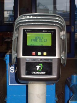
Figure 3-3. Electronic Fare Payment
Photo courtesy of TranSystems. All rights reserved.
Safety and Security/Assistive Technologies
These technologies work to ensure that safety and security is furnished to provider personnel and passengers (throughout their trip). These technologies includes onboard safety and security systems, station/stop safety and security, and AT that provide individual safety.
- Onboard safety and security systems. These systems typically consist of audio and video surveillance equipment and emergency alarms, which are all located on the vehicle. These surveillance and emergency systems are frequently integrated with AVL technology. Therefore, when an incident or emergency does occur, employees in the transit operations center can respond, and sometimes view the activity taking place on-board, in real-time. Many fixed route transit systems currently use this technology and a few demand-response systems have begun to introduce this technology.
- Station/stop location safety and security systems. These systems use the same technologies as onboard systems and are typically monitored in real-time by operations center staff. An additional element that stations can use is intercoms, which allow customers to have a direct line to the operations center should there be an emergency. The presence and operation of these systems is frequently enough to reduce criminal activity in these locations.
- Assistive Technologies. Assistive Technologies, which are described in the following section, include intelligent pedestrian signals, Talking Signs, talking bus stops, personal way finding aids, automatic restraint systems, and personal location devices. These technologies help to make it possible for persons with disabilities and others to use public transportation more independently.
3.1.2 Assistive Technologies
AT help people with disabilities access transportation and increase mobility. Some of the technologies are built into the transportation infrastructure and are for public use, some are purchased by individuals and are private, and some are a combination of public and private investments (e.g., Talking Signs® infrastructure and personal reading device). Examples of several AT are discussed below.
- Intelligent Pedestrian Signals and Other Intelligent Wayside Technologies. These technologies are built into the infrastructure and do not need an accompanying personal assistive device. They include sensory and processing technologies at the wayside to automate certain functions that are currently activated manually. Intelligent pedestrian signals automatically detect individuals wishing to cross the street and place a call to the traffic signal controller to change the traffic signal and signal timing to allow pedestrians to negotiate the street safely. Figure 3-4 illustrates this type of system in use.
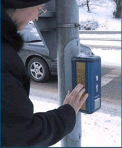
Figure 3-4. Intelligent Pedestrian Crossing
Photo courtesy of USDOT. All rights reserved.
- Audible Signs. These systems include audible signs in transit stations, at transit stops, and on transit vehicles that emit infrared signals that are then detected and read by a hand-held receiver, such as a web-enabled cell phone or PDA. Information is displayed on the handheld device, or communicated through a headset or speaker. Talking Signs® is one example. This technology permits persons with vision impairments to navigate transit centers and other permanent structures by identifying key landmarks such as entrances, exits, restroom facilities, information booths, bus bays, and train tracks. This technology is also becoming available in other public buildings.
- Personal Way Finders and Built Environment Navigation Aids. This technology provides pre-loaded pictures, maps and/or directions in a PDA for people with cognitive impairments so they can "see" their route and find their way.
- Personal Location Monitoring and Assistance. This technology application provides personal location monitoring so that individuals with Alzheimer's disease, other cognitive disabilities, or vision impairments can be tracked and provided a "life-line" to assist them during incidents or times when they stray from their expected route.
3.1.3 Other Supporting Technologies
In addition to ITS and AT technology solutions, the MSAA research has noted physical solutions based on technology that can be implemented to meet the needs of people who are transportation disadvantaged. Many of these solutions relate specifically to vehicle accessibility, environmental access, and, to some extent, reduction of information barriers. Examples of these solutions include: (1) boarding assistance and (2) signage and information.
Boarding Assistance
Except for most subways, accessing transit vehicles often requires the use of steps, ramps, or lifts. Some examples of level boarding assistance include low floor buses and minivans that reduce the height and number of steps required to enter and exit vehicles, thereby making it easier for persons with mobility aids, packages, luggage, and baby strollers to enter and exit the vehicles. The low floor vehicles also allow for the use of ramps for people who use wheelchairs or scooters or who otherwise cannot negotiate steps. In addition, some buses have a kneeling feature, which reduces the height of the first step. Lifts continue to be a significant feature on fixed route buses and demand-response vans with standard floor heights.
Rail stations are required to be accessible for all new construction and for stations that are designated as key stations under the Americans with Disabilities Act (ADA) regulations and ADA Accessibility Guidelines (ADAAG). Elevators, ramps, and/or escalators are used to make stations with multiple levels accessible for persons who cannot use stairs. Raised platforms for commuter rail, light rail and bus rapid transit (BRT) also are used to permit level boarding, sometimes requiring use of a bridge plate to span the gap between the vehicle floor and boarding platform. These raised platforms are typically accessed by a ramp and may run the entire length of the boarding platform or be located at one end and accessed via a "min-high" platform. Platform edges at accessible stations are marked by detectable warning strips, which indicate the edge of platforms and other drop-offs for persons with vision impairments. Additional attention has been paid in recent years to identifying gaps between rail cars, particularly for persons with vision impairments who may mistakenly think that the gap is a vehicle doorway.
Signage and Information
In addition to signage required by the Americans with Disabilities Act Accessibility Guidelines (ADAAG), some systems offer Braille displays, color coding on system maps, simpler maps and schedules, and maps and other amenities keyed to tactile surfaces for way finding. All of these amenities make it easier for persons with disabilities to use traditional transit services. As described in the ITS technologies section, additional options for customer service and help lines, such as telephone-based, Internet-based, cell phone-based, and Interactive Voice Response (IVR) based services, are becoming available along with the introduction of the 511 traveler information system (active in 24 locations) and the 211 health and human service information system (active in all or part of 32 States), which can be dialed from a cell phone. Some systems also are developing detailed inventories of bus stops, rail stations, and the surrounding infrastructure to provide better access to information for customers with disabilities. These inventories also can be used to establish local priorities for upgrading stops, stations, and the surrounding community infrastructure. This information also may be used to ascertain trip-by-trip eligibility for ADA complementary paratransit trips more accurately.
Footnotes
- Photo courtesy of Carol Schweiger, TranSystems Corporation.
- USDOT, Federal Highway Administration, 511 American's Traveler Information Telephone Number, February 15, 2005, https://ops.fhwa.dot.gov/511/